November 7, 2017
Unburying a Rille
Originally published May 1, 2008

image by Pete Lawrence, Selsey, England
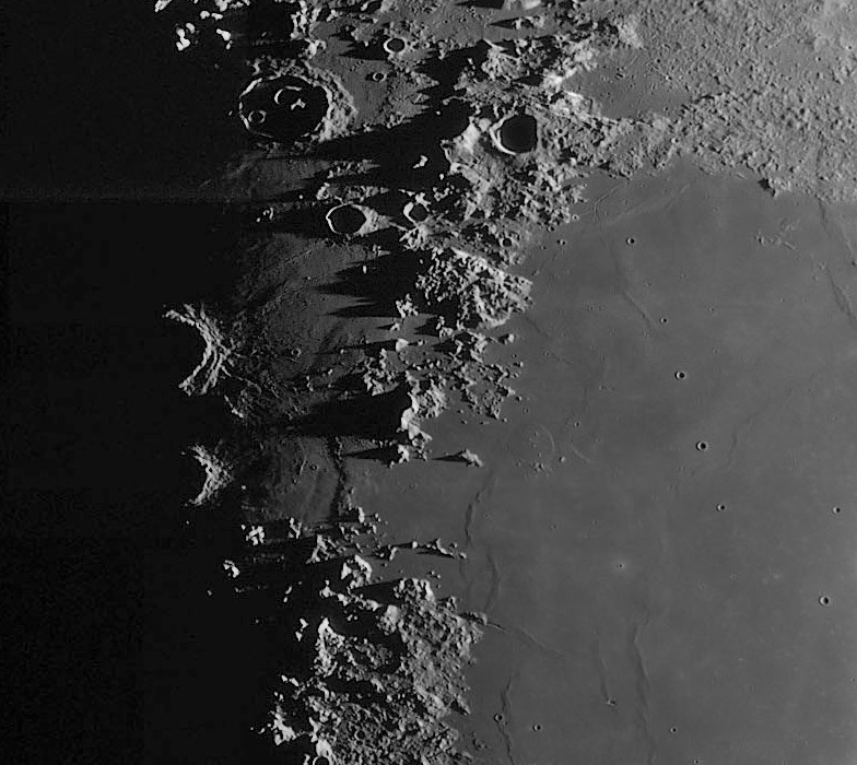
Poor Pete. The seeing wasn't very good so all he could manage was prime focus, wide-field imaging. But what an image. This is the romantic view that makes shivers run down your spine when observing visually. The jagged shadows of the Caucasus dramatically explain the mistaken 19th century belief that lunar topography was vertiginous. Little Linné is a pin-prick (with shadow) in western Serenitatis, the Valentine dome is clearly rendered, and the famous line of small craters in northwestern Serenitatis really does look unnaturally straight. But my attention is drawn to the gap between the Apennines and Caucasus where it appears that Serenitatis lavas flowed down into Imbrium. The new Kaguya topographic map (when seen at full resolution and color-balance shifted to better see contour intervals) shows that both Serenitatis and Imbrium are lower than the gap area - lava didn't flow from one mare to the other. The odd, flat-topped mare ridge in the gap is what gives the mistaken impression, and perhaps the lateral forces that caused that ridge continued to the north where a slightly less prominent ridge occurs. What I don't remember seeing before is the shallow trough terminator-ward of the gap's ridge. This is the continuation of one of the truncated flat-floored Fresnel rilles in the older Apennine Bench terrain immediately to the south. Is this the discovery image of this buried rille? (It is seen on Paolo's early image, but its true origin was not recognized.) Think what Pete might have captured with good seeing.
Chuck Wood
Technical Details
12th April 2008, 21h 46m UT. Celestron 14" + Lumenera SKYnyx 2-0M + mono webcam + Astronomik red filter.
Related Links
Rükl plate 12, 13, 22 & 23
Pete's new Moonwatching site with tilting thumbnails - don't get dizzy.
Yesterday's LPOD: Was I Wrong?
Tomorrow's LPOD: I'm Going To the Moon
COMMENTS
(1) If lava didn't flow between the two, than does that mean that the source of the lava in the gap is from the gap itself? - Aethrae, Andrew Martin SFO
(2) Chuck--I wish I had more skill in identifying the features you've described! I can't tell which pinprick is Linne and am guessing at the location of the Valentine Dome and other features. It would be helpful for beginners like me to see an annotated version of images like this. I realize, of course, that you probably don't have the time to do this, but I can still wish. :)
--Bill
P.S. Is the area in the image in the northwestern part of Serenitatus...?
(3) Andrew - yes, lava doesn't flow uphill so there must be a local source (if the Kaguya contours are correct).
Bill - Sorry that you and others have difficulty in identifications. I constantly use the S&T Field Map of the Moon as a reference, and strongly recommend it. But it doesn't stop me from getting directions wrong - its one of the failings I noticed coming on with age. Linne is the pit with a shadow and a bright nimbus in the bottom right quadrant of the image.
Stefan Lammel has tried to help me figure out how to display a mouse-over annotated image but I couldn't get it to work. And you are right, I don't have much time available to increase the effort on LPOD, but I would do it sometimes. I don't like to annotate directly on the image.
--Chuck
COMMENTS?
Register, Log in, and join in the comments.


