November 30, 2013
A Table of Contents

image by Mike Salway, Australia
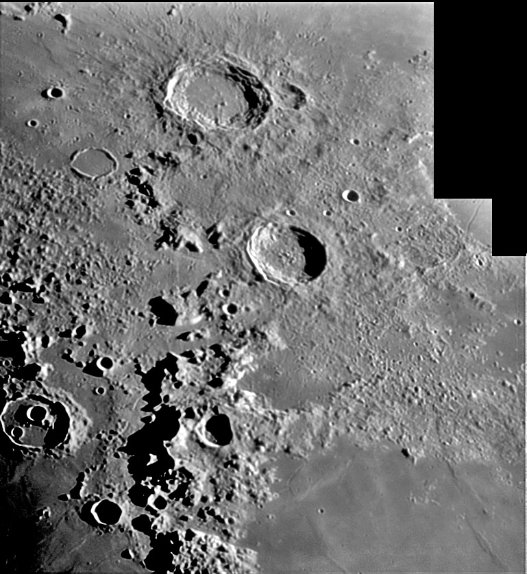
Each image tells many stories. Rather than telling just one, here is the Table of Contents for this view. It is a variagated scene with smooth mare, jagged mountains, rubbly debris and scads of craters, mostly fresh. At bottom right is the northwest corner of Serentitatis, including a broad swell cut by the branching Calippus Rille. Running north-south are the Caucasus Mountains with jet black shadows (can shadows ever be saturated?) - why are there isolated blocks like the 30 km one between Eudoxus and Cassini? East of the sharp face of the Caucasus is a mountainous terrain that decreases in roughness over 300-400 km to the east; this is Imbrium ejecta. Immediately west of the Caucasus front is subdued topography crossed by rilles and littered with hills and small craters - this is older terrain than Mare Imbrium that had a more complex history. Eudoxus (67 km diameter) and younger Aristoteles (87 km) are odd because they should - as large complex craters - have massive central peaks; why don’t they? And how could Mitchell, the 30 km crater whose west rim was pulverized by Aristoteles, have survived that close encounter without more damage? Egede (37 km) found another way to accelerate its aging process. When Frigoris lavas welled up and flowed across the low zone north of the Imbrium Basin rim they couldn’t get into Egede (because the wall is unbroken) so they had to rise up faults under the crater to flood its floor. You will have to read the book yourself to get the rest of the story.
Chuck Wood
This is a classic LPOD from September 7, 2006
Technical Details
31st August 2006. 10″ dob on EQ platform + 2x barlow with DMK21AF04 + green filter + 18-pt MAP processing in Registax 3, AstraImage and Photoshop
Related Links
21st Century Atlas chart 10.
Mike's website
Yesterday's LPOD: New Crater Formed?
Tomorrow's LPOD: Updated Contents
COMMENTS?
Register, Log in, and join in the comments.


