May 30, 2008
Ah-Ha!

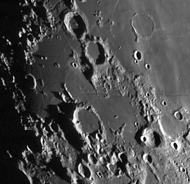
image by K.C. Pau, Hong Kong
I have long wondered why the Ramsden Rilles existed. What were the forces that produced them? KC's signature low illumination view suggests an answer. Ramsden is the crater nearly completely in shadow at the far left of the image. The Ramsden Rilles are a series of interlocking ones that don't seem related to the Humorum or Nubium impact basins. If you look closely at the rille area around Ramsden you will notice that the mare material there is slightly rougher textured and appears to be higher than nearby parts of Palus Epidemiarum. I bet that this area has been very slightly uplifted, causing the surface to fracture. The Ramsden Rilles have an unusual pattern - they intersect and seem to radiate from a point just south of the crater, which is probably the center of uplift. This fracture pattern is familiar to bakers - bread crust sometimes looks this way when the crust cools and interior gases are still hot and expand. Volcanologists talk of bread crust bombs which are ejected pieces of lava whose hot interiors fracture the cooled outer edges. I don't find evidence from the Kaguya topo map that this area is elevated, but the resolution of the map is inadequate to be certain.
Chuck Wood
Technical Details
May 15, 2008. 250mm f/6 Newtonian + DMK31AF03 camera + 2.5X barlow; processing with CS2. Lat.: 22º 15' N, Long.:114º 10' E; elevation is 0 meter.
KC is visiting Iceland now and probably won't see his LPOD - someone needs to let him know when he returns to Hong Kong.
Related Links
Rükl plate 63
Yesterday's LPOD: Lunar Furniture
Tomorrow's LPOD: Oppie
COMMENTS
(1) By the way...
It's that question again...
Why is the group of hillocks between Campanus and Kies (top of KC's photo) called Golubiz cluster on Rand Mc Nally's moonmap?
Who (or what) is (or was) Golubiz ???
P.S.:
This is one of the most stubborn mysteries in lunar nomenclature.
--Danny C.
COMMENTS?
Register, Log in, and join in the comments.


