December 2, 2018
Part 1 of a Global Topography
Originally published September 18, 2009

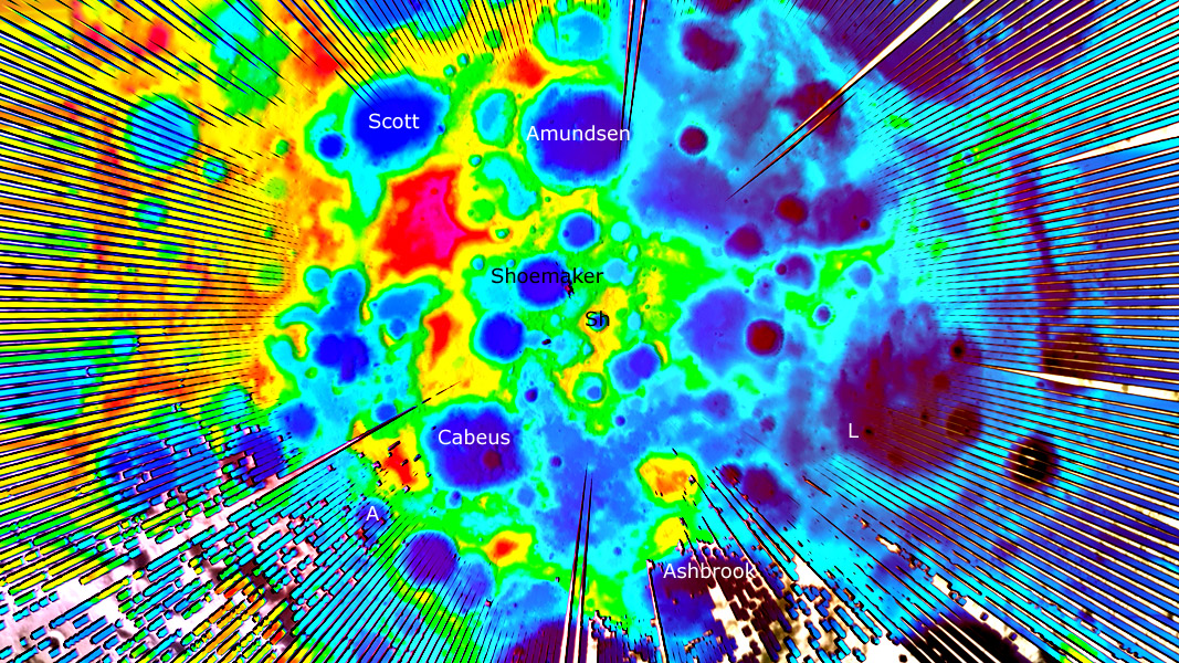
image by NASA/Goddard Space Flight Center Scientific Visualization Studio; nomenclature added and colors enhanced by CAW; left is nearside.
Today NASA held a press conference to give results from early studies of the lunar south polar area by the Lunar Reconnaissance Orbiter. Some of the most fascinating initial data comes from LOLA - Lunar Orbiter Laser Altimeter. This is essentially the same instrument that orbited Mars so the team has great experience in processing and visualizing results, and since every orbit passes over the poles there is already a dense network of observations. This overview of the south pole shows the now familiar trio of Haworth, Shoemaker and Faustini (between Cabeus and Amundsen). To the right is Shackelton (Sh) the small steep-sided crater that is nominally America's goal for polar exploration. LOLA has made a high resolution cross section of Shackleton's floor, documenting the 50 m topography of hills previously imaged by Kaguya. Further left is a broad, purple-floored (deep) depression that isn't as obvious in normal images - the small crater Laveran (L) is within it. This depression is ringed for about 180° by hills and then an annular depression - could this be an unrecognized impact basin?
Chuck Wood
Technical Details
Incomplete mapping leaves gaps between altimeter tracks - there are no gaps near the south pole and they become pervasive further out from the pole.
Links
As usual, Emily Lakdawalla provides an in-depth review of this new data.
Yesterday's LPOD: Return of the Sky
Tomorrow's LPOD: LPOD News
COMMENTS?
Register, Log in, and join in the comments.


