October 7, 2023
Ina (But No Gadda Da Vida)
Originally published September 22, 2013

images produced by Brian Day using NASA’s Lunar Mapping and Modeling Portal
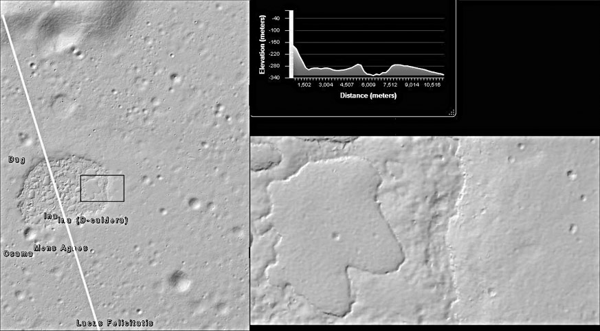
Ina has fascinated me ever since Pete Schultz introduced me to it several years ago. The possibility of a young feature indicating recent geologic lunar activity was fascinating. Subsequent high-resolution studies using LRO have increased the area’s mystery. The Terrain Viewer in NASA’s Lunar Mapping and Modeling Portal (LMMP) enabled generating this intriguing oblique view of the area using LRO NAC image and DEM data. The hills north of Ina are seen to the left. Using LMMP’s Terrain Viewer, I have often walked and flown down these slopes, crossed the flat floor of Lacus Felicitatis and wandered into the weirdly-sculpted terrain of Ina. More often, I’ve just stood on the heights and imagined this as a vantage for viewing whatever forces gave rise to Ina. In the image below, the line of LMMP’s path tool traces the line of the elevation plot at upper right, revealing Ina as a caldera-like depression surrounded by an apparent shallow dome. The black rectangle shows the area enlarged at lower right. This illustrates the contrast between the higher, smooth regions and the lower, rough terrain. It also shows the similar number of craters on the higher terrain within Ina and the surrounding floor of Felicitatis versus the relative scarcity of craters in the low regions of Ina.
Brian Day
Note from CAW: Brian leads Education and Public Outreach programs for the LADEE Mission.

Related Links
21st Century Atlas chart 11.
Another note from CAW: Not about the Moon but too cool not to share.
Yesterday's LPOD: A New Theory, Part 2
Tomorrow's LPOD: ?
COMMENTS?
Register, Log in, and join in the comments.


