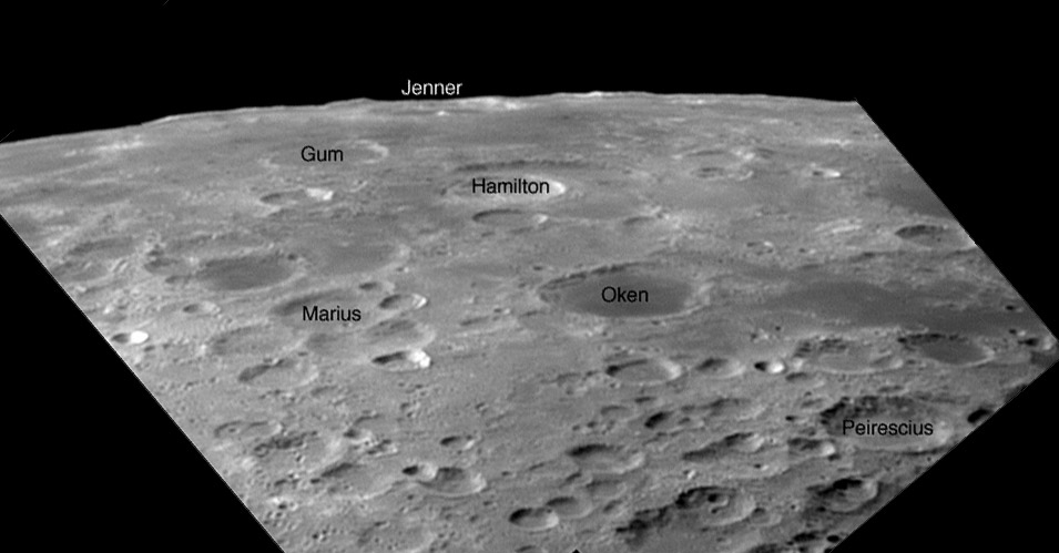
image by Achille Giordano, Naples, Italy
Other than dark-floored Oken I have always had trouble identifing features on the extreme southeast limb when observing. Two reasons are that excellent librations such as this are rare, and maps - even Rükl’s wonderful Atlas of the Moon - are difficult to decipher close to the limb. Sure, The Clementine Atlas of the Moon shows this area with clarity, but that overhead perspective is not what I need at the telescope. One solution would be to construct schematic charts such as Whitaker’s classic one of the south polar region. Another solution would be to create a collection of annotated limb images, such as this one by Achille that I have added a few names to. This approach was actually carried to completion by Alexander Vandenbohede in 2005. His free online book, Observing the Lunar Libration Zones is a splendid example of an amateur creating a valuable resource for all to share. And improvements in imaging are coming so fast that higher resolution images - such as today’s LPOD - could be used to assemble an improved limb atlas. The LTVT software would make it easy to correctly identify named and lettered craters.
Technical Details:
22 April, 2007, 19:47UT. ETX 125 Mak f/15 + 2X Barlow Apo +DMK 21AF04 As, mosaic of 2 images with 201 frames each; Registax 4. Note that the limb passes through the farside of Gum, and that the bright central peak of Jenner is at about 96°E! The mountain ridges beyond Jenner may be at Lamb and beyond - 100° and further east!
Related Links:
Rükl chart 69
Herring’s limb drawings
Yesterday's LPOD: A New Myth
Tomorrow's LPOD: Parallax by Day
COMMENTS?
Register, Log in, and join in the comments.


