March 28, 2015
LTO
Originally published March 27, 2004
Image Credit: Lunar & Planetary Institute Map Collection |
|
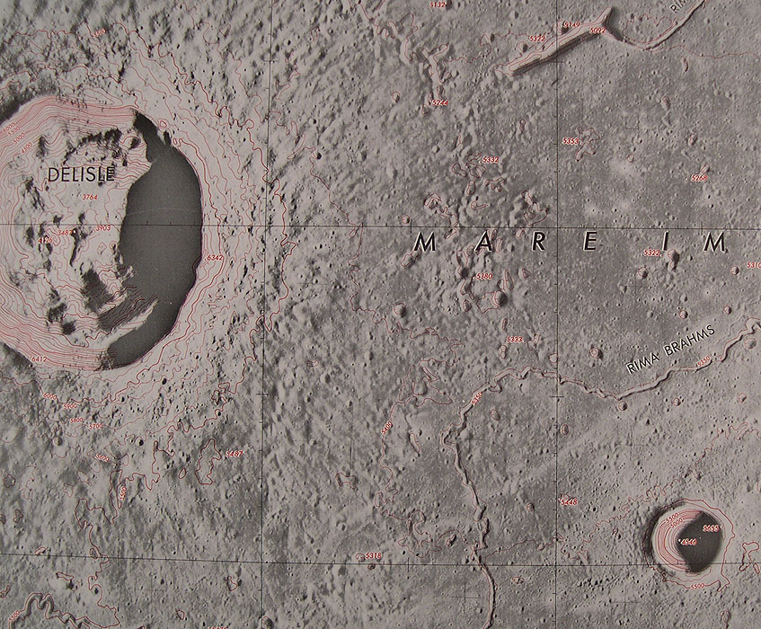
LTO Lunar Topographic Orthophotomosaic. That mouthful explains the widespread use of the abbreviation LTO for the best topo images ever made for the Moon. Derived from stereo images taken from Apollo orbiting command modules, more than 250 LTOs were produced covering much of the landscape under the flight paths of Apollo 15, 16 and 17. This particular image shows a portion of LTO 39B2 of western Mare Imbrium. The 25 km wide crater Delisle is on the left and Diophantus B is on the right. This map has a scale of 1:250,000 and a contour interval of 100 m. Diophantus B has a diameter of 6.1 km, and by reading the spot heights on its rim (5665 m) and floor (4546 m), its depth of 1,119 m is accurately obtained. Thus, this fresh little simple crater has a depth to diameter (d/D) ratio of about 1/5 - the crater's depth is 1/5th its width. This is typical of small fresh craters; larger ones such as Tycho have a d/D value of about 1/18, and a basin such as Orientale is roughly 1/100. There are arguments about how deep a crater/basin is when first excavated - the transient cavity - but modification of this initial hole shallows the final crater. Modification is by wall slumps and terraces, floor rebound, and maybe for basins, isostatic adjustment. We need LTOs for the entire Moon - and they need to be available online. Related Links: Yesterday's LPOD: Six Little Volcanoes Tomorrow's LPOD: A Quadrant of Elger |
|
Author & Editor: |
COMMENTS?
Register, Log in, and join in the comments.


