June 25, 2008
A New Rille?

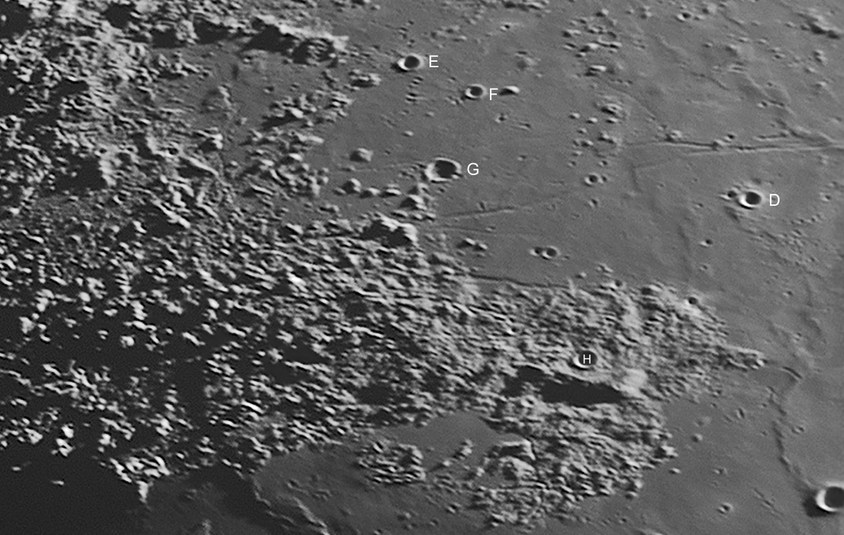
image by Stefan Lammel
Another LPOD, another discovery. At least a discovery using Earth images. More later, the overview first. The western end of Lacus Somniorum is rich with linear rilles that are very delicate and difficult to image. These are all generally considered parts of the Daniell Rilles, probably because the rille at top right points back to the crater Daniell. On a previous image by Wes Higgins a new member of this diffuse family was recognized and it is well seen here. This is the very faint rille north of the crater Plana G. This rille appears to extend into the Imbrium ejecta rubble to the south that I call the map. I have not found a telescopic image of the rille, and I bet that the 1972 map plots the rille only because it was seen on the Orbiter image. Is this the discovery telescopic image for this rille?
Chuck Wood
Technical Details
11-Apr-08 19:58UT. 10in f4.8 Newtonian, Infinity 2-1M, 4x PowerMate, green filter, 500/1100, MAP: 64x64, Registax, PSE 5, Focus Magic.
Related Links
Rükl plate 14
KC's image
Yesterday's LPOD: Unknown Volcanic Center
Tomorrow's LPOD: Outrageous Idea
COMMENTS
1. A side-by-side comparison of how the photographic resolution of the small region containing the "new" rille has improved from the Consolidated Lunar Atlas through Stefan's latest image can be found on the LTVT Wiki LPOD Notes page. Opening the indentically-sized images presented there in multiple browser windows or tabs makes it possible to blink between any of these and the Geologic Map -- somewhat simulating the LTVT experience. As with other small lunar features, in hindsight there is probably no sharply defined moment at which this rille shifted from barely noticeable to obvious in the best Earth-based photos. -  JimMosher
2.What I really noticed in this photo and the "Lost Peninsula" photo is difference in perspective. In the above it seems the angle of view is from a lower perspective while the other image seems to be from looking more straight downward. Can the angle of polar tilt account for that much difference in viewing angle or is it in combination with other factors like position along the ecliptic? (high in the sky or low in the sky) Don Loftus - Gainesville, Florida
3. Don - The "Lost Peninsula" (22°E/37°N) is about 42° from the Moon's center, as viewed from Earth; which means that, on average, we view it inclined at that angle. The tilt of the Moon's pole towards or away from us can subtract or add another 10° or so to that -- so we do see it sometimes more inclined than others, but never from an overhead perspective. What counts is what point we see as being at the Moon's center, and that has very little to do with whether the Moon is high or low in the sky. With its maximum tilt (~52°), the "Lost Peninsula" is compressed by foreshortening to about 0.73 of the width it would have at the minimum tilt (~32°).
I think your impression that the earlier LPOD view looks more overhead than the present one is largely a psychological effect due to the different lighting and orientation. Also, the present LPOD shows only a portion of the area visible in the "Lost Peninsula" view, and the part it shows is the one with the strongest tilt.
The exact geometry of the two views could be compared more exactly if the date and time of the "Lost Peninsula" photo were known, but unfortunately, it's not. However, if you have access to a photo processing software you can try downloading today's LPOD photo and then reducing it to 79% of its present size. After rotating it clockwise by 36° you'll notice that its view of this area is really quite similar (but with a different lighting) to the one in the "Lost Peninsula" photo. -  JimMosher
COMMENTS?
Register, Log in, and join in the comments.


