July 22, 2015
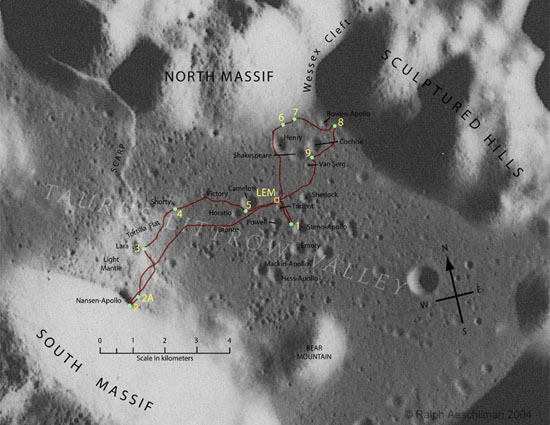
Taurus-Littrow Route Map
Originally published July 21, 2004
Image Credit: Ralph Aeschliman |
|
Taurus-Littrow Route Map With the use of a rover, astronauts on the last three Apollo missions could travel so far that a route map was need before the mission and afterwards to get a geographical (or selenographical for purists) understanding of their explorations. Apollo 17, humanity's last lunar visit, was the most daring - the Lunar Module Challenger came in low over the Taurus Mountains for a pin-point landing on a small flat plain surrounded by mountains, and the astronauts drove the rover a record 36 km. The two main science goals were to sample ancient rocks, hopefully older than the Imbrium impact, and the dark volcanic deposits that might be young. The long trips to North (12 km) and South (20 km) Massifs allowed sampling of rocks that proved to be greater than 4.2 billion years old, but the hoped for young volcanism - the dark mantle material including orange glass at Shorty Crater: Station 4) - was also ancient: 3.64 billion years. Apollo 17 provided evidence for explosive volcanism, but not youthful volcanism on the Moon. Technical Details: Related Links: Yesterday's LPOD: The Beginning of the End of the Future Tomorrow's LPOD: Huge Fractures |
Author & Editor: |
COMMENTS?
Register, Log in, and join in the comments.


