image by Ivan Gonçalves, Nîmes, France
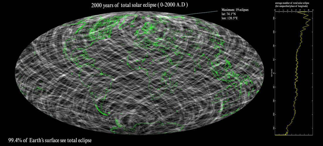
This is a fascinating image that I don’t completely understand. Ivan has calculated which areas of the Earth’s surface were shadowed during total solar eclipses from 0 to 2000 AD. This map shows the outline of the continents in green and the background in black. Except there is almost no black, for each place where a solar eclispe was visible is lighter hued. Where eclipse paths cross, the hue is brighter. The stripes crossing the Earth map out recurring eclipse tracks. Nearly every portion of the Earth’s surface (99.4%) has wittnessed one or more eclipses. But some areas - especially in the northern polar regions - see more eclipses, the maximum being 19 eclipses from 74.1°N, 120.5°E in northern Siberia. The graph on the right shows the number of eclipse tracks visible in latitude bands circling the Earth. Near the South Pole only 2-3 eclipses have been visible over the last 2000 years, but at about 80°N the average is 8. Ivan suggests that the northern concentration of eclipses is because total solar eclipses of the northern hemisphere generally take place in summer. During the northern hemisphere summer the sun is further from the Earth, thus its apparent diameter has a tendency to be smaller than the apparent diameter of the moon, resulting in more total eclipses.
Related Links:
Eclipse map 2001-2025
Yesterday's LPOD: More New Features?
Tomorrow's LPOD: A 42 Year Old Letter
COMMENTS?
Register, Log in, and join in the comments.


