February 27, 2022
A Tilting Tale
Originally published April 13, 2012

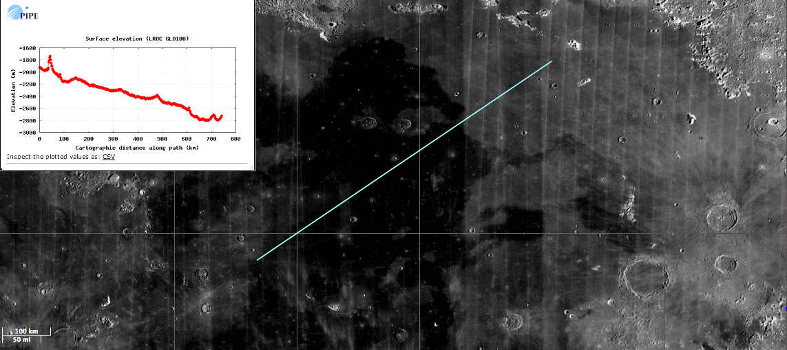
image by Maurice Collins and Chuck Wood
Maurice has been exploring the recent additions to the Lunar Reconnaissance Orbiter Camera team's ACT--REACT Quick Map interactive website. The Quick Map has become a favorite tool because it provides easy access to the LRO WAC mosaic and the addition of a topography profile tool, based on the LOLA altimeter allows instant mapping of lunar ups and downs. At the same time the altimetry was added so were images from the Moon Mineralogy Mapper at the 1489 nanometer wavelength. This is in the near infra-red or reflective infra-red part of the spectrum which clearly distinguishes the young lava flows in Imbrium. Maurice made a 1489 nm image of Imbrium and then constructed a topographic profile across it, starting in the west near the lava's vents. I repeated Maurice's work, combining the profile with the map to get a single image. The dark flows are generally younger than the gray ones, based on superposition relationships - darks are typically on top of lights in Imbrium. The topo trace confirms that the dark lavas flowed downhill. Based on a number of profiles the surface of Imbrium tilts relentless downward to the east by about 800-1000 m, and also tilts downward by about the same amount to the north. In fact, the northern end of Sinus Iridum is deeper yet, accounting for the observation that some of the young lavas flowed toward Imbrium's center and then turned northward toward Iridum. It is unexpected that the lowest spot of the Imbrium Basin is not near the center of the basin. Was it formed on terrain that already sloped to the NE?
Chuck Wood
Yesterday's LPOD: Best View in the Solar System
Tomorrow's LPOD: What Caused the Melting?
COMMENTS?
Register, Log in, and join in the comments.


