December 21, 2023
Down, Up, And Down the Alpine Valley
Originally published December 4, 2013

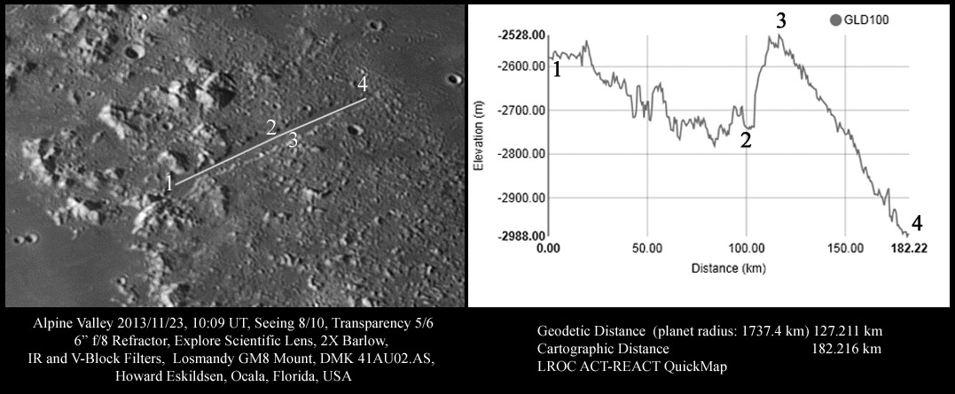
image by Howard Eskildsen, Ocala, Florida
The Alpine Valley appears quite flat as it courses through the lunar Alpes, and considering that it only drops about 400 meters over a course of the 127 km (geodetic distance) marked on this image, it drops on average about 3 meters per kilometer over that distance. However, as can be seen on the chart, a little over midway from left to right on the image, there is an abrupt increase in elevation of the valley floor of about 200 meters. From point 1 to 2 the elevation drops about 160 meters over about 65 km (geodetic distance) for a downward slope of about 2.5 meters per kilometer, slightly shallower than the average slope. From 3 to 4 the elevation drops about 460 meters over 42 km for a drop of about 11 meters per kilometer. There is a rise in elevation of about 210 meters between those two segments over a course of about 20 km (geodetic distance) for a rise in elevation of about 11 meters per kilometer, but the steepest part of the rise ascends 200 meters over about 7 km for a rise of 29 meters per km. Since the valley floor appears to consist of basalt that was once molten, it might be assumed that at one time the Alpine Valley floor was essentially flat and that the notable changes in elevation occurred after the lavas had solidified. I wonder why.
This is not the only valley that has curious changes in elevation that must have occurred after the molten basalt solidified. Schröter's Valley, through which lava flowed from the Aristarchus Plateau into Procellarum, has a 200 meter rise in elevation over its final 60 km course towards the stormy sea. Since molten basalt once flowed out of the valley, the rise must have occurred after the flows were finished. Though the two valleys had different origins, and the reasons for their elevation changes may be different, it is curious to note that significant surface changes are likely to have occurred long after the lavas cooled.
Howard Eskildsen
Note by CAW: This is a nice piece of work. LRO-QuickMap shows that a mare ridge cuts across the Alpine Valley floor where the 200 m rise in elevation occurs. But as Howard's altimetry traverse shows, the ridge doesn't just make a bump, but the entire floor east of the ridge has a different slope. Perhaps the ridge marks a fault that tilted the eastern portion of the Valley. Support for this idea comes from running other traverses paralleling the Valley across the rubbly Imbrium ejecta. A traverse just north of the Valley shows the same uplift and decline, but none is visible immediately on the south side of the Valley (but further south a similar rise and tail is seen). The Apennines and the Alps are cut by a variety of major faults so it isn't completely surprising that there may be one here. But it would be totally unknown without the LRO topo that allowed Howard to discover it. Also, the ridge has been seen before but until today the magnitude of the associated rise and the discontinuous slope to the east were unappreciated. Finally, although I know that basin ejecta is high near the rim and tapers off radially away, sometimes it looks like lava could have flowed into Imbrium. But the topo shows what makes sense, that lava flowed from Imbrium down the Valley. And as Howard said, sometime later when it was all solid it was broken and tilted. Strange.
Related Links
21st Century Atlas chart 10.
Yesterday's LPOD: Digitally Painted Mistress of the Night
Tomorrow's LPOD: An Epidemic of Wonders
COMMENTS?
Register, Log in, and join in the comments.


