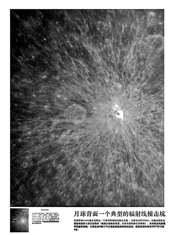
Chang’e image by China National Space Administration
The China National Space Administration is quietly releasing a few lunar images as Chang’e begins its year or more of mapping the Moon. This image, an example of creating a topo image map, and a detailed illustration of how the first released image was mosaicked together (perhaps in response to the ignorant flap about it being a fake) are at a CNSA site that does not have an English page. Click on the [12.09] entry of the index table at upper right to see the illustration of compositing the first image. Today’s image is of a small but brilliant unnamed ray crater on the farside - not the dark side as in a Chinese English language news site. The ray crater is at about 100°W, 3.4°N, just to the east (right) of the 23 km wide crater Lenz C. The magnificent ray crater has a diameter of about 9 km and its rays are easily seen 150 km distant. With enhancements, dark bands can be seen on the interior slopes of the crater, and the off-center dark patch is probably impact melt (but why would it coat the steep wall slope?). This is the sort of landmark that should have a name; I hope that someday the IAU will honor it, perhaps with the name of a Chinese astronomer such as Zhang Sui, who in the early 700s reputedly discovered the proper motion of stars. It would be wonderful if someone who is fluent in Chinese could translate the captions of this and future Chang’e press releases!
Related Links:
Clementine Atlas sheet 72
Yesterday's LPOD: No Beer Here
Tomorrow's LPOD: Blinded by Blandness
COMMENTS?
Register, Log in, and join in the comments.


