August 18, 2010
Two Looks, Same Data

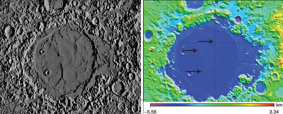
right image from LOLA Image of the Week, June 2, 2010, and left by Maurice Collins
Occasionally the Lunar Orbiter Laser Altimeter (LOLA) team releases a topographic image of an area of interest. In this case (right), it was the Crisium Basin, with the colors indicating carefully measured elevations (although the altitude scale is nearly impossible to use). An alternative visualization of the same data is provided by Maurice's creation of a synthetic image (left) using LTVT software. Because the effective illumination angle of the left image is very low (1°), the subtle mare ridges on the floor of Mare Crisium are very easy to see. In fact, although the areas indicated on the right by arrows are said to be "lava flow features" they are simply mare ridges, made of basaltic material, but presumably formed by tectonics. It has been suggested by Pete Schultz and Rob Wichmann that Crisium formed by an oblique impact, with the projectile coming from the west. That reasonable suggestion is based partly on the lack of a mountainous rim to the east and the extension of mare lavas that way. But the altimetry data show that the inner ridge ring does not share that elongation to the east, in fact it is somewhat flatter than the more strongly curved western side.
Chuck Wood//
Technical Details
I tried overlaying these two views but their scales varied across the image so that rubber-sheet adjustments were required - more than I could do in Photoshop!
Related Links
Rükl plate 26
Yesterday's LPOD: The Eye vs the DTM
Tomorrow's LPOD: A Beacon in a Corridor of Murkiness
COMMENTS?
Register, Log in, and join in the comments.


