April 1, 2019
Orientale Windfall
Originally published January 21, 2010

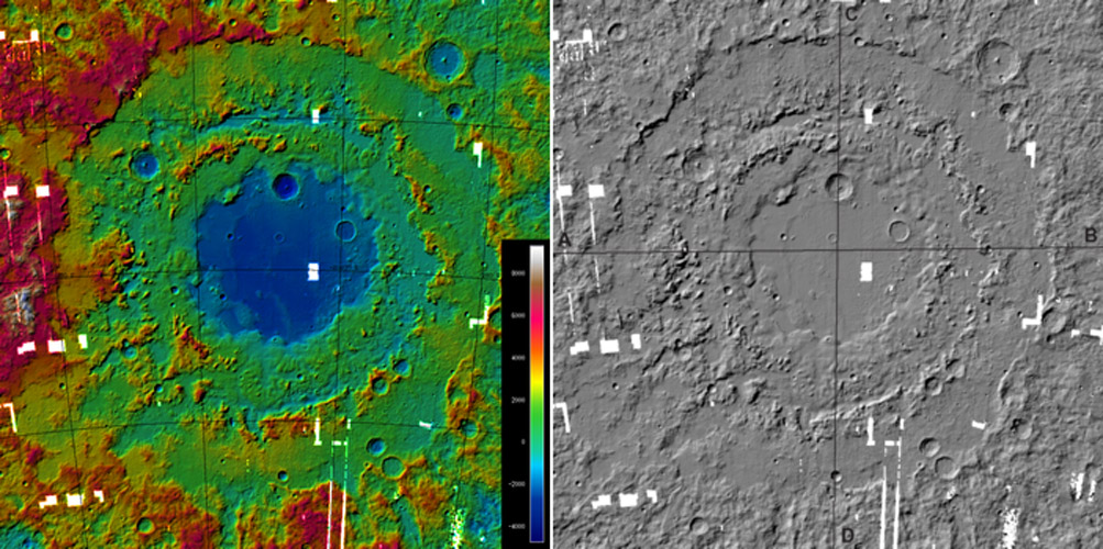
topographic images from LRO, ASU and DLR; white spots are missing data
More complex products begin to emerge from the Lunar Reconnaissance Orbiter team. This wonderful topo map of the Orientale Basin, and a shaded relief version of it, were created by determining elevations from stereo produced by overlap of the frames from the Wide Angle Camera (WAC) on LRO. Similar stereo mapping of the entire Moon is well underway and we can expect see a global map constructed from 10,000 WAC images. This will be a totally independent topo map from the one being made from the laser altimeter data. The dominant feature of the colored map above - beyond the three concentric rings of the Cordillera, Outer Rook and Inner Rook mountains - is the difference in elevation from the farside (red) to the nearside (green). There is more than 2 km difference is heights of the Cordillera from west to east because of this regional trend. Lunar Orbiter never clearly depicted the western side of Orientale, and now we can see the breakup of symmetry there. The sharp scarp of the Cordillera disappears in the lower left quadrant and the rim is distorted outward, perhaps due to pre-existing large craters. Cross sections shown on the LRO website demonstrate that the mare floor is 8-9 km below the Cordillera rim. The preservation of this deep hole since its formation about 3.8 billion years old is proof that the lunar crust has been too strong to deform. On Earth, a similar basin depth would long ago been isostatically reduced to almost nothing.
Chuck Wood
Related Links
Rükl plate VII
Yesterday's LPOD: The Moon From Brazil
Tomorrow's LPOD: Caressing Rays
COMMENTS?
Register, Log in, and join in the comments.


