Difference between revisions of "June 14, 2007"

From LPOD
Jump to: navigation, search
(Created page with "__NOTOC__ =Something for Everyone= <div class="post" id="post-1182"> <div class="storycontent"> <p>File:Arago-ritter-sabine20070423SM-ENH_lazz.jpg|arago-ritter-sabi...")
 
 
(6 intermediate revisions by the same user not shown)
Line 1: Line 1:
 
__NOTOC__
 
__NOTOC__
 
=Something for Everyone=
 
=Something for Everyone=
 +
<!-- Start of content -->
 +
<div class="post" id="post-1182">
  
+
<div class="storycontent">
<div class="post" id="post-1182">
+
<p>[[File:Arago-ritter-sabine20070423SM-ENH_lazz.jpg|arago-ritter-sabine20070423SM-ENH_lazz.jpg]]<br />
 
<div class="storycontent">
 
<p>[[File:Arago-ritter-sabine20070423SM-ENH_lazz.jpg|arago-ritter-sabine20070423SM-ENH_lazz.jpg]]<br />
 
 
<em>image by [mailto:paolo@lazzarotti-optics.com  Paolo R. Lazzarotti], Massa, Italy.</em></p>
 
<em>image by [mailto:paolo@lazzarotti-optics.com  Paolo R. Lazzarotti], Massa, Italy.</em></p>
 
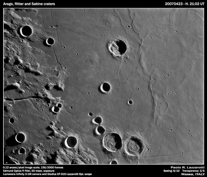
<p>The southwestern shore of Mare Tranquillitatis is one of the most diversely fascinating places on the Moon. And Paolo&#8217;s recent image gives new insights into the history of the area. The highlights are Arago with it central mountain that seems to reach the crater rim, the Arago domes (above and to the crater&#8217;s left), the concentric mare rings of Lamont, the untwins of Sabine and Ritter, the concentric rilles that mark where subsidence of the mare fractured its edges, and the short striations on the rough terrain to the west that were caused by the flow of Imbrium ejecta. I see some other things as well. To the west of Manners is a subtly rough roundish patch with the texture and hue of the Arago domes, but with a slightly larger diameter. Is this another large, but low relief, dome? Also notice the two Hypatia rilles in the lower right corner near the Apollo 11 landing site. Paolo&#8217;s image hints that the northern rille extends considerably further east than generally mapped. The diverenge in angle and morphology suggest that the two rilles may have formed in response to different forces. The southern rille is concentric to the basin edge implying that like most rilles here, it is a subsidence rille. The northern rille perhaps is not. Another intriguing rille is at the eastern end of the Ariadaeus Rille at the center left. A short fork of the rille bends south and is roughly concentric with the Tranquillitatis basin edge - was it also formed by the subsidence of the mare lavas? This is agreat image - keep looking to find other questions and maybe some answers!</p>
 
<p>The southwestern shore of Mare Tranquillitatis is one of the most diversely fascinating places on the Moon. And Paolo&#8217;s recent image gives new insights into the history of the area. The highlights are Arago with it central mountain that seems to reach the crater rim, the Arago domes (above and to the crater&#8217;s left), the concentric mare rings of Lamont, the untwins of Sabine and Ritter, the concentric rilles that mark where subsidence of the mare fractured its edges, and the short striations on the rough terrain to the west that were caused by the flow of Imbrium ejecta. I see some other things as well. To the west of Manners is a subtly rough roundish patch with the texture and hue of the Arago domes, but with a slightly larger diameter. Is this another large, but low relief, dome? Also notice the two Hypatia rilles in the lower right corner near the Apollo 11 landing site. Paolo&#8217;s image hints that the northern rille extends considerably further east than generally mapped. The diverenge in angle and morphology suggest that the two rilles may have formed in response to different forces. The southern rille is concentric to the basin edge implying that like most rilles here, it is a subsidence rille. The northern rille perhaps is not. Another intriguing rille is at the eastern end of the Ariadaeus Rille at the center left. A short fork of the rille bends south and is roughly concentric with the Tranquillitatis basin edge - was it also formed by the subsidence of the mare lavas? This is agreat image - keep looking to find other questions and maybe some answers!</p>
Line 16: Line 15:
 
[http://www.lazzarotti-hires.com/ Paolo’s website]<br />
 
[http://www.lazzarotti-hires.com/ Paolo’s website]<br />
 
[http://www.lazzarotti-optics.com/main.html The amazing telescope that creates these images]</p>
 
[http://www.lazzarotti-optics.com/main.html The amazing telescope that creates these images]</p>
<div align="center">Don’t forget to add yourself - as [http://www.frappr.com/?a=viewphoto&#038;id=3301085&#038;pid=5698142" Paolo] has done - to the growing list of lunatics at [http://www.lpod.org/?m=20070509 Frappr LPOD]!</p>
+
<p><b>Yesterday's LPOD:</b> [[June 13, 2007|Scooting Past]] </p>
<p><i>You can support LPOD when you buy ANY book from Amazon thru [[LPOD]]</i>
+
<p><b>Tomorrow's LPOD:</b> [[June 15, 2007|Get Out Your Red-Blue Glasses Again]] </p>
 
</div>
 
</div>
</div>
+
<p> </p>
+
<p> </p>
 
+
<p> </p>
----
+
<!-- End of content -->
===COMMENTS?===
+
{{wiki/ArticleFooter}}
Click on this icon [[image:PostIcon.jpg]] at the upper right to post a comment.
 

Latest revision as of 19:58, 8 February 2015

Something for Everyone

arago-ritter-sabine20070423SM-ENH_lazz.jpg
image by Paolo R. Lazzarotti, Massa, Italy.

The southwestern shore of Mare Tranquillitatis is one of the most diversely fascinating places on the Moon. And Paolo’s recent image gives new insights into the history of the area. The highlights are Arago with it central mountain that seems to reach the crater rim, the Arago domes (above and to the crater’s left), the concentric mare rings of Lamont, the untwins of Sabine and Ritter, the concentric rilles that mark where subsidence of the mare fractured its edges, and the short striations on the rough terrain to the west that were caused by the flow of Imbrium ejecta. I see some other things as well. To the west of Manners is a subtly rough roundish patch with the texture and hue of the Arago domes, but with a slightly larger diameter. Is this another large, but low relief, dome? Also notice the two Hypatia rilles in the lower right corner near the Apollo 11 landing site. Paolo’s image hints that the northern rille extends considerably further east than generally mapped. The diverenge in angle and morphology suggest that the two rilles may have formed in response to different forces. The southern rille is concentric to the basin edge implying that like most rilles here, it is a subsidence rille. The northern rille perhaps is not. Another intriguing rille is at the eastern end of the Ariadaeus Rille at the center left. A short fork of the rille bends south and is roughly concentric with the Tranquillitatis basin edge - was it also formed by the subsidence of the mare lavas? This is agreat image - keep looking to find other questions and maybe some answers!

Chuck Wood

Technical Details:
23 April 2007, 21:02 UT. Gladius CF-315 Lazzarotti telescope (f/25), Lumenera Infinity 2-1M camera, Edmund Optics R filter, 150 frames stack out of 2000. CAW applied Tony Gondola’s contrast mask technique to Paolo’s image. The original - and larger - image is here.

Related Links:
Rükl plate 35
Paolo’s website
The amazing telescope that creates these images

Yesterday's LPOD: Scooting Past

Tomorrow's LPOD: Get Out Your Red-Blue Glasses Again


COMMENTS?

Register, Log in, and join in the comments.