Difference between revisions of "January 13, 2011"
(Created page with "__NOTOC__ =Blue And Red Maria, not States= <!-- ws:start:WikiTextHeadingRule:0:<h1> --> <!-- ws:start:WikiTextLocalImageRule:6:<img src="/file/view/LPOD-Jan1...") |
|||
| (9 intermediate revisions by the same user not shown) | |||
| Line 1: | Line 1: | ||
__NOTOC__ | __NOTOC__ | ||
=Blue And Red Maria, not States= | =Blue And Red Maria, not States= | ||
| − | + | <!-- Start of content --> | |
| − | + | <!-- ws:start:WikiTextHeadingRule:0:<h1> --> | |
| − | + | <!-- ws:start:WikiTextLocalImageRule:6:<img src="/file/view/LPOD-Jan13-11.jpg/192892756/LPOD-Jan13-11.jpg" alt="" title="" /> -->[[File:LPOD-Jan13-11.jpg|LPOD-Jan13-11.jpg]]<!-- ws:end:WikiTextLocalImageRule:6 --><br /> | |
image by [mailto:tomlinda@bigpond.net.au Tom Harradine], Australia <br /> | image by [mailto:tomlinda@bigpond.net.au Tom Harradine], Australia <br /> | ||
<br /> | <br /> | ||
| − | Tom is teaching us [ | + | Tom is teaching us [[January_4,_2011|new ways]] to see the Moon. Here he has fused one of his saturated color full Moon |
| + | images with a terrain map from the recent LOLA 64 DEM data from the Lunar Reconnaissance Orbiter. | ||
| + | Once again Jim Mosher's invaluable [http://ltvt.wikispaces.com/LTVT Lunar Terminator Visualization Tool] program was used to create | ||
| + | this unearthly perspective view. The Sun shines with a 1° incidence angle over every point, and the | ||
| + | view is from an angle not possible from Earth. The vantage point is from over the Taurus Mountains, with | ||
| + | the Sea of Serenity (ochre, to the right) and the blue Sea on Tranquility to the left. Tom pointed it out, and | ||
| + | I never knew it - see how the shadows demonstrate that Serenitatis is lower than Tranquillity, with an | ||
| + | otherwise unnoticed scarp at their juncture. It is interesting to see that the bluest area of Tranquillity is to | ||
| + | the west, which [http://www2.lpod.org/wiki/August_17,_2009 other] topo data show is lower than the center and east parts of the mare - it is not at all | ||
| + | certain that there is an underlying basin there. [http://www2.lpod.org/wiki/April_27,_2010 As before], it looks like the location of the Cauchy fault | ||
| + | and rille may result from being on a local linear rise, with each break in the crust occurring where the | ||
| + | surface slopes downward. | ||
<br /> | <br /> | ||
| + | <br /> | ||
| + | <em>[mailto:tychocrater@yahoo.com Chuck Wood]</em><br /> | ||
| + | <br /> | ||
| + | <p><b>Yesterday's LPOD:</b> [[January 12, 2011|The Moon is Dead]] </p> | ||
| + | <p><b>Tomorrow's LPOD:</b> [[January 15, 2011|Menage a Trois]] </p> | ||
<hr /> | <hr /> | ||
| − | + | {{wiki/ArticleFooter}} | |
| − | |||
| − | |||
| − | |||
Latest revision as of 08:27, 28 October 2018
Blue And Red Maria, not States

image by Tom Harradine, Australia
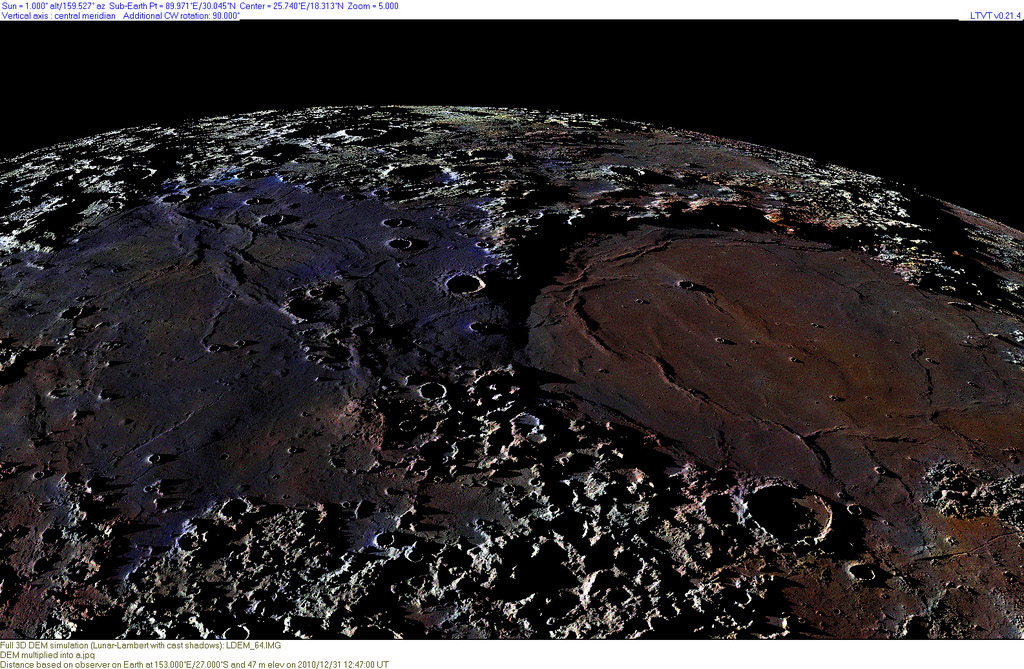
Tom is teaching us new ways to see the Moon. Here he has fused one of his saturated color full Moon
images with a terrain map from the recent LOLA 64 DEM data from the Lunar Reconnaissance Orbiter.
Once again Jim Mosher's invaluable Lunar Terminator Visualization Tool program was used to create
this unearthly perspective view. The Sun shines with a 1° incidence angle over every point, and the
view is from an angle not possible from Earth. The vantage point is from over the Taurus Mountains, with
the Sea of Serenity (ochre, to the right) and the blue Sea on Tranquility to the left. Tom pointed it out, and
I never knew it - see how the shadows demonstrate that Serenitatis is lower than Tranquillity, with an
otherwise unnoticed scarp at their juncture. It is interesting to see that the bluest area of Tranquillity is to
the west, which other topo data show is lower than the center and east parts of the mare - it is not at all
certain that there is an underlying basin there. As before, it looks like the location of the Cauchy fault
and rille may result from being on a local linear rise, with each break in the crust occurring where the
surface slopes downward.
Chuck Wood
Yesterday's LPOD: The Moon is Dead
Tomorrow's LPOD: Menage a Trois
COMMENTS?
Register, Log in, and join in the comments.


