July 11, 2008
No More Crater

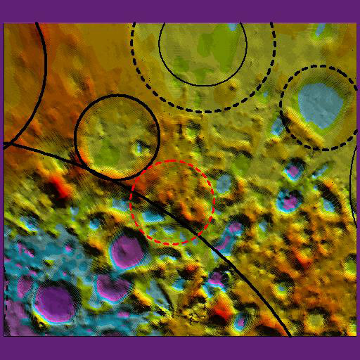
topographic map image by Chris Bodine
I am Christopher Bodine, a high school student and intern at NASA Goddard Space Flight Center. The possible crater mentioned in the July 9 LOPD was brought to my attention by Noah Petro (NASA Goddard), and since I have access to the GRIDVIEW analysis program and the relevant Clementine topographic data, I decided to look for the mystery crater. On this topographic map view the red is the possible crater, the solid black circles are basins visible in visual images, and dashed black lines are basins only visible in topographic maps. The big black arc through the possible crater is the probable rim of the South Pole-Aikten Basin (SPA). The topographic data does not indicate that there is a crater here; the curved feature appears to be formed largely from the rims of several craters, including Bailly, le Gentil, Drygalski, and smaller craters in that area. Also, some of the curve is in SPA, whose rim passes right through the crater. It is unlikely that such a feature would survive if SPA overlaid it (not to mention that it is unlikely that anything would have survived if it’s older than SPA).
Chris Bodine
Technical Details
This is an exported image from GRIDVIEW (developed by Jim Roark, NASA Goddard Space Flight Center) showing a topographic moon model derived primarily from Clementine data. Basins and craters are represented by black circles
Related Links
Rükl plate 72
(Happy iPhone day!)
Yesterday's LPOD: Rilles And Hills
Tomorrow's LPOD: Another View


