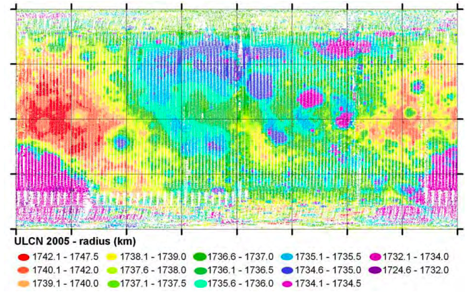
image from Brent Archinal & USGS colleagues
Lunar topographic maps have been made by accurately measuring travel times of pings of energy sent from orbiting spacecraft, but an older method developed for Earth measures has produced the map here. Since at least the 1890s accurate measurements of the positions of lunar landmarks at various times when there were different librations allowed estimates of the deviation of each point from an assumed spherical shape. Early on such measures (a control point network) deduced the existence of a bulge towards Earth, and by 1963 Ralph Baldwin’s measurements of 696 points led to a broadly accurate map showing that the maria were substantially lower than the highlands and that not all maria were at the same level. The map above is based upon 272,931 points! This vast collection of points (largely based on automatic measurements on Clementine images) was analysed by Brent Archinal and colleagues at the US Geological Survey, and is called the Unified Lunar Control Network 2005. On average, there is a point about every 6.8 km along the surface, and the accuracy of the horizontal and vertical locations is reported as several hundred meters. Compared to the Clementine LIDAR altimetry map (AM) the general topography is very similar, but there are important differences. The total range of elevation on the AM is 16 km, but strangely it is 23 km for the control network map (CNM). The CNM also depicts the depressions associated with basins as broader than on the AM. For example, Procellarum, Imbrium, Frigoris and Serenitatis merge into a broad lowland area on CNM. In looking in detail at the two maps it may be that some of the differences are due to color schemes - on CNM the color palette was chosen so that low highlands around basins are commonly yellow, but in AM they, like the maria, are all shades of blue. It occurs to me that with high resolution full Moon images and precision measurements using image processing software it would be possible for an amateur to create a control network topo map too!
Technical Details:
This map comes from the two-page abstracts for the upcoming 38th Lunar and Planetary Science Conference which were placed online Friday afternoon. These mini-papers are the largest and most up-to-date reports on lunar and planetary science that are published during the year. Have fun exploring them - maybe you’ll even stumble on my four about Titan.
Related Links:
R.B. Baldwin (1963) The Measure of the Moon, chapter 11.
Yesterday's LPOD: The Edge of a Bull's Eye
Tomorrow's LPOD: A Horrible Map
COMMENTS?
Register, Log in, and join in the comments.


