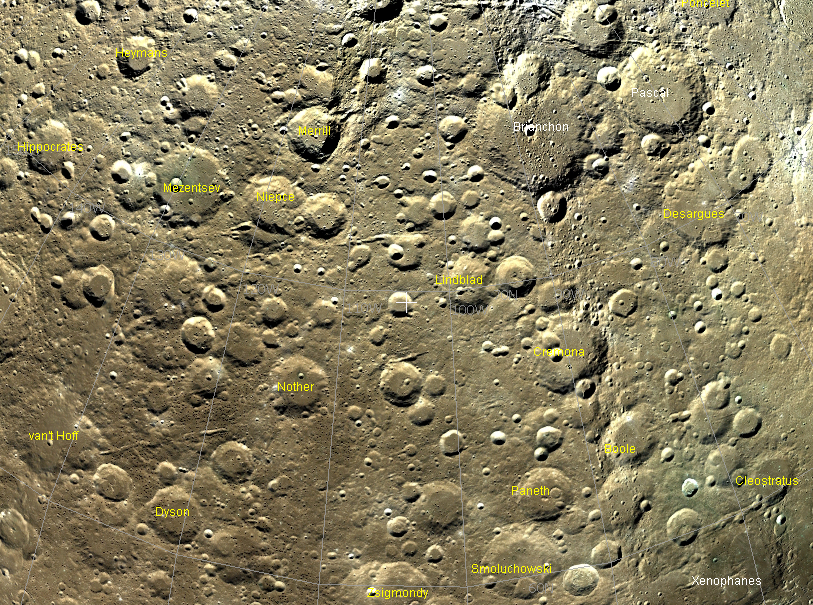
image from NASA WorldWind Moon, courtesy Dr. Beaumie Kim
NASA developed the WorldWind project to make Earth remote sensing data readily available to everyone. WorldWind demonstrated that visualization and interaction with massive amounts of data could be fun, inspiring and even addicting. In October 2005, WorldWind added the Moon so that you can now sail over Clementine images and digital terrain maps, effortlessly spinning the Moon like a beachball and zooming in and out for the perfect view of your area of interest. WorldWind’s Moon (WWM) also displays grid lines and names of craters. I had previously ignored the power of WWM because it is only available for PCs, not Macs (although the new Macs can be degraded to run Windows at high speed). But after playing with WWM today I strongly recommend it to all lunar students. Although the same Clementine image mosaic is available at Map-A-Planet and on the excellent Virtual Lunar Atlas, the ease of use of WWM makes it a delight for rambling over the lunar surface. WWM is especially valuable for exploring the farside where the ability to easily roam and zoom (along with the coordinate grid) help immensely in finding your way. This sample image of an area straddling the north-northwest limb illustrates another feature of WWM - the ability to view any area from overhead (as well as obliquely). This image highlights a series of linear features that appear to radiate from a source out of the image to the right. I never realized before seeing this WWM depiction that there was such a prominent array of features - secondary crater chains? - in this polar area. Too bad I don’t have access to WWM at home - I’d just twirl the Moon around and see what the source is! Maybe you can solve the mystery!
Technical Details:
Centered at 104°W, 70°N. WWM uses the Clementine color albedo mosaic which includes many black strips where one of the necessary color bands is missing. On a future version it would be valuable to fill these gaps with B x W images, which are usually available. Finally, WWM is an amazing tool - it would be wonderful to have some lesson plans that use it to teach lunar geology for astronomy lab courses.
Related Links:
Rükl chart: Libration Zone I
Yesterday's LPOD: A Lunar Nebula
Tomorrow's LPOD: Unrolling the Edge
COMMENTS?
Register, Log in, and join in the comments.


