|
|
| (4 intermediate revisions by the same user not shown) |
| Line 1: |
Line 1: |
| | __NOTOC__ | | __NOTOC__ |
| | =A New Fault?= | | =A New Fault?= |
| | + | <!-- Start of content --> |
| | <div class="post" id="post-1462"> | | <div class="post" id="post-1462"> |
| | | | |
| Line 6: |
Line 7: |
| | <p>[[File:Littrow-Fault-LPOD.jpg|Littrow-Fault-LPOD.jpg]]<br /> | | <p>[[File:Littrow-Fault-LPOD.jpg|Littrow-Fault-LPOD.jpg]]<br /> |
| | <em>image by [mailto:s_fire@online.ua Павел Пресняков (Pavel Presnyakov)], Kiev Ukraine</em></p> | | <em>image by [mailto:s_fire@online.ua Павел Пресняков (Pavel Presnyakov)], Kiev Ukraine</em></p> |
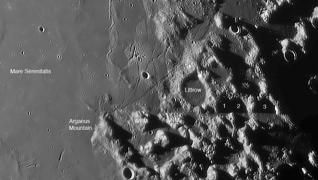
| − | <p>The eastern shore of Mare Serenitatis is familiar territory with Posidonius, le Monnier and the Taurus-Littrow Apollo 17 landing area. That makes it all the more surprising that there is an absolutely conspicuous feature in Pavel’s image that I’ve never noticed before. Do you see the horizontal line that extends across the north end of the Argaeus Mountain to the south side of Littrow? The truncated ends of the West Family Mountain (WFM) and the North Massif (NM) strongly suggest the line is a boundary, as do the ends of the coincidental shadows of the unlettered half craters 1, 2 and 3. A high Sun [[TL050922.jpg|view]] shows that the southern halves of these craters are missing, as if they had been sheared off. A lower Sun [[September_21,_2004|image]] confirms that the linear trend is not an artifact. So what is it? The Argaeus Mountain and the massifs that surround the Apollo 17 site jut out westward further than the adjacent hilly terrain north or south of it. It is tempting to say that this area slid westward into its present position, with the Littrow Fault (new informal name) as the sliding boundary. But there is no equivalent boundary on the south side. The missing southern walls of the ruined craters 1, 2 and 3, and the truncated northern edges of WFM and NM suggest that material was faulted - if it didn’t move sideways did it drop down? Possibly, but again, no real supporting evidence. Often lunar faults are radial to large impact basins, but this one isn’t. Finally, faults are often deep conduits for magma. Perhaps the Littrow Fault was a deep passageway for the gas-rich magmas that emplaced the dark pyroclastic deposits in the Apollo 17 area. These are all speculations, but what seems to be real is the linear feature itself.</p> | + | <p>The eastern shore of Mare Serenitatis is familiar territory with Posidonius, le Monnier and the Taurus-Littrow Apollo 17 landing area. That makes it all the more surprising that there is an absolutely conspicuous feature in Pavel’s image that I’ve never noticed before. Do you see the horizontal line that extends across the north end of the Argaeus Mountain to the south side of Littrow? The truncated ends of the West Family Mountain (WFM) and the North Massif (NM) strongly suggest the line is a boundary, as do the ends of the coincidental shadows of the unlettered half craters 1, 2 and 3. A high Sun [http://www.hq.nasa.gov/alsj/a17/TL050922.jpg view] shows that the southern halves of these craters are missing, as if they had been sheared off. A lower Sun [[September_21,_2004|image]] confirms that the linear trend is not an artifact. So what is it? The Argaeus Mountain and the massifs that surround the Apollo 17 site jut out westward further than the adjacent hilly terrain north or south of it. It is tempting to say that this area slid westward into its present position, with the Littrow Fault (new informal name) as the sliding boundary. But there is no equivalent boundary on the south side. The missing southern walls of the ruined craters 1, 2 and 3, and the truncated northern edges of WFM and NM suggest that material was faulted - if it didn’t move sideways did it drop down? Possibly, but again, no real supporting evidence. Often lunar faults are radial to large impact basins, but this one isn’t. Finally, faults are often deep conduits for magma. Perhaps the Littrow Fault was a deep passageway for the gas-rich magmas that emplaced the dark pyroclastic deposits in the Apollo 17 area. These are all speculations, but what seems to be real is the linear feature itself.</p> |
| | <p>[mailto:tychocrater@yahoo.com Chuck Wood]</p> | | <p>[mailto:tychocrater@yahoo.com Chuck Wood]</p> |
| | <p><strong>Technical Details:</strong><br /> | | <p><strong>Technical Details:</strong><br /> |
| Line 13: |
Line 14: |
| | Rükl plates 24 & 25<br /> | | Rükl plates 24 & 25<br /> |
| | [http://www.astroclub.kiev.ua/gallery/search.php?search_user=S.Fire Pavel’s website]</p> | | [http://www.astroclub.kiev.ua/gallery/search.php?search_user=S.Fire Pavel’s website]</p> |
| − | <div align="center"><em>LPOD earns a commission when you buy ANY book from Amazon thru </em><em>[[LPOD]]<br /> | + | <p><b>Yesterday's LPOD:</b> [[October 21, 2007|A Wonderful Corner]] </p> |
| − | </em></div> | + | <p><b>Tomorrow's LPOD:</b> [[October 23, 2007|Colorful Topo]] </p> |
| | </div> | | </div> |
| − | ----
| + | <p> </p> |
| − | ===COMMENTS?===
| + | <p> </p> |
| − | Register, and click on the <b>Discussion</b> tab at the top of the page.
| + | <p> </p> |
| | + | <!-- End of content --> |
| | + | {{wiki/ArticleFooter}} |


