Difference between revisions of "April 28, 2013"
| Line 11: | Line 11: | ||
<em>[mailto:tychocrater@yahoo.com Chuck Wood]</em><br /> | <em>[mailto:tychocrater@yahoo.com Chuck Wood]</em><br /> | ||
<strong>Related Links</strong><br /> | <strong>Related Links</strong><br /> | ||
| − | <em>[ | + | <em>[[21st Century Atlas of the Moon|21st Century Atlas]]</em> chart 11.<br /> |
</td> | </td> | ||
</tr> | </tr> | ||
Latest revision as of 07:23, 28 October 2018
Still Confused After All These Years
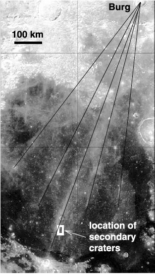
 annotated Clementine image from Bart and Melosh, 2007 |
I continue to be confused by the Bessel Ray. The one thing that is fairly certain is that Bessel is not the source crater for this ray that crosses the middle of Mare Serenitatis. Tycho seems like a possible source because the ray, if extrapolated southward, comes close to Tycho. But Tycho has no other rays anywhere near as long. The other occasionally mentioned source is Menelaus which cuts the Haemus Mountains on the south shore of Serenitatis. But Menelaus was formed by an oblique impact and its rays go towards the southeast. Another posible paternity is indicated by an apparent continuation of the ray past the east sides of Lacus Mortis and Frigoris to the young crater Thales. Thales is far enough north that the full distribution of its rays can not be seen, but there does seem to be an odd slim triangle of rays that spreads between the Bessel ray and a possible thin ray that passes through Franklin. That ray, if it is real, is not as long as the Thales to Bessel distance. Remote sensing studies indicated that 40% of the blocky Bessel ray is highlands material. But that could be ejecta from highlands under Tycho, Menelaus or Thales. Today I learned of another proposed source that I have overlooked for six years. In 2007 Gwen Bart and Jay Melosh published a paper in which they accepted that the Bessel ray and four others in Serenitatis radiate from Bürg, the 39 km complex crater in Lacus Mortis. Their five ray lines passing through bright areas do converge on Bürg but I am uncertain if Bürg is a ray crater. And I am not certain that the bright areas are rays, although this image supports that interpretation. For Bürg to be consistent with the remote sensing evidence Bürg would have to excavate highlands rocks, which may or may not exist under Lacus Mortis' lavas. So you can see why I am still confused. Chuck Wood |
Yesterday's LPOD: Leaving No Dome Unturned
Tomorrow's LPOD: Half a Crater
COMMENTS?
Register, Log in, and join in the comments.


