Difference between revisions of "July 14, 2012"
| (One intermediate revision by the same user not shown) | |||
| Line 7: | Line 7: | ||
<br /> | <br /> | ||
Maps are essential to finding your way around a museum, a city or even a moon. There are more maps of our Moon | Maps are essential to finding your way around a museum, a city or even a moon. There are more maps of our Moon | ||
| − | than of all the others combined, probably. [ | + | than of all the others combined, probably. [https://the-moon.us/wiki/Lunar_Maps Maps] come in all sizes and styles and none is perfect. So make your own |
for your particular needs. That is what Howard has done with one of his full Moon views of the north polar region. Such | for your particular needs. That is what Howard has done with one of his full Moon views of the north polar region. Such | ||
high Sun lighting is the only time all of the near polar region can be seen at once, but the illumination makes it difficult | high Sun lighting is the only time all of the near polar region can be seen at once, but the illumination makes it difficult | ||
| Line 17: | Line 17: | ||
<br /> | <br /> | ||
<strong>Related Links</strong><br /> | <strong>Related Links</strong><br /> | ||
| − | Rükl plate [ | + | Rükl plate [https://the-moon.us/wiki/R%C3%BCkl_3 3] and others.<br /> |
<br /> | <br /> | ||
<p><b>Yesterday's LPOD:</b> [[July 13, 2012|Sliced]] </p> | <p><b>Yesterday's LPOD:</b> [[July 13, 2012|Sliced]] </p> | ||
Latest revision as of 17:48, 13 October 2018
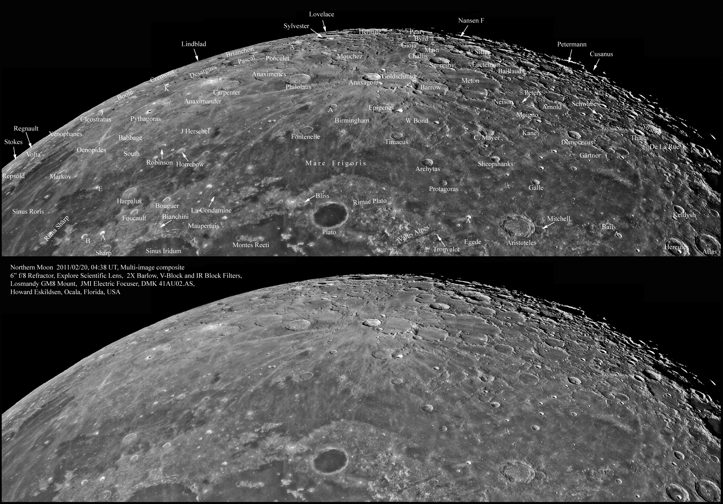
Northern Exposure

image by Howard Eskildsen
Maps are essential to finding your way around a museum, a city or even a moon. There are more maps of our Moon
than of all the others combined, probably. Maps come in all sizes and styles and none is perfect. So make your own
for your particular needs. That is what Howard has done with one of his full Moon views of the north polar region. Such
high Sun lighting is the only time all of the near polar region can be seen at once, but the illumination makes it difficult
to appreciate the morphology of all the craters - one of the tradeoffs that maps require. But if you want to identify the
features when the Sun is high, or if you just want a neat poster, this map is for you.
Chuck Wood
Related Links
Rükl plate 3 and others.
Yesterday's LPOD: Sliced
Tomorrow's LPOD: A Brighter Eye for Taurus
COMMENTS?
Register, Log in, and join in the comments.


