Difference between revisions of "August 9, 2012"
| (3 intermediate revisions by the same user not shown) | |||
| Line 1: | Line 1: | ||
__NOTOC__ | __NOTOC__ | ||
=More Flows= | =More Flows= | ||
| + | <!-- Start of content --> | ||
<!-- ws:start:WikiTextHeadingRule:0:<h1> --> | <!-- ws:start:WikiTextHeadingRule:0:<h1> --> | ||
<!-- ws:start:WikiTextLocalImageRule:14:<img src="/file/view/LPOD-Aug9-12.jpg/356957626/LPOD-Aug9-12.jpg" alt="" title="" /> -->[[File:LPOD-Aug9-12.jpg|LPOD-Aug9-12.jpg]]<!-- ws:end:WikiTextLocalImageRule:14 --><br /> | <!-- ws:start:WikiTextLocalImageRule:14:<img src="/file/view/LPOD-Aug9-12.jpg/356957626/LPOD-Aug9-12.jpg" alt="" title="" /> -->[[File:LPOD-Aug9-12.jpg|LPOD-Aug9-12.jpg]]<!-- ws:end:WikiTextLocalImageRule:14 --><br /> | ||
| Line 8: | Line 9: | ||
<td><!-- ws:start:WikiTextLocalImageRule:15:<img src="/file/view/LPOD-Aug9b-12.jpg/356959024/LPOD-Aug9b-12.jpg" alt="" title="" /> -->[[File:LPOD-Aug9b-12.jpg|LPOD-Aug9b-12.jpg]]<!-- ws:end:WikiTextLocalImageRule:15 --><br /> | <td><!-- ws:start:WikiTextLocalImageRule:15:<img src="/file/view/LPOD-Aug9b-12.jpg/356959024/LPOD-Aug9b-12.jpg" alt="" title="" /> -->[[File:LPOD-Aug9b-12.jpg|LPOD-Aug9b-12.jpg]]<!-- ws:end:WikiTextLocalImageRule:15 --><br /> | ||
</td> | </td> | ||
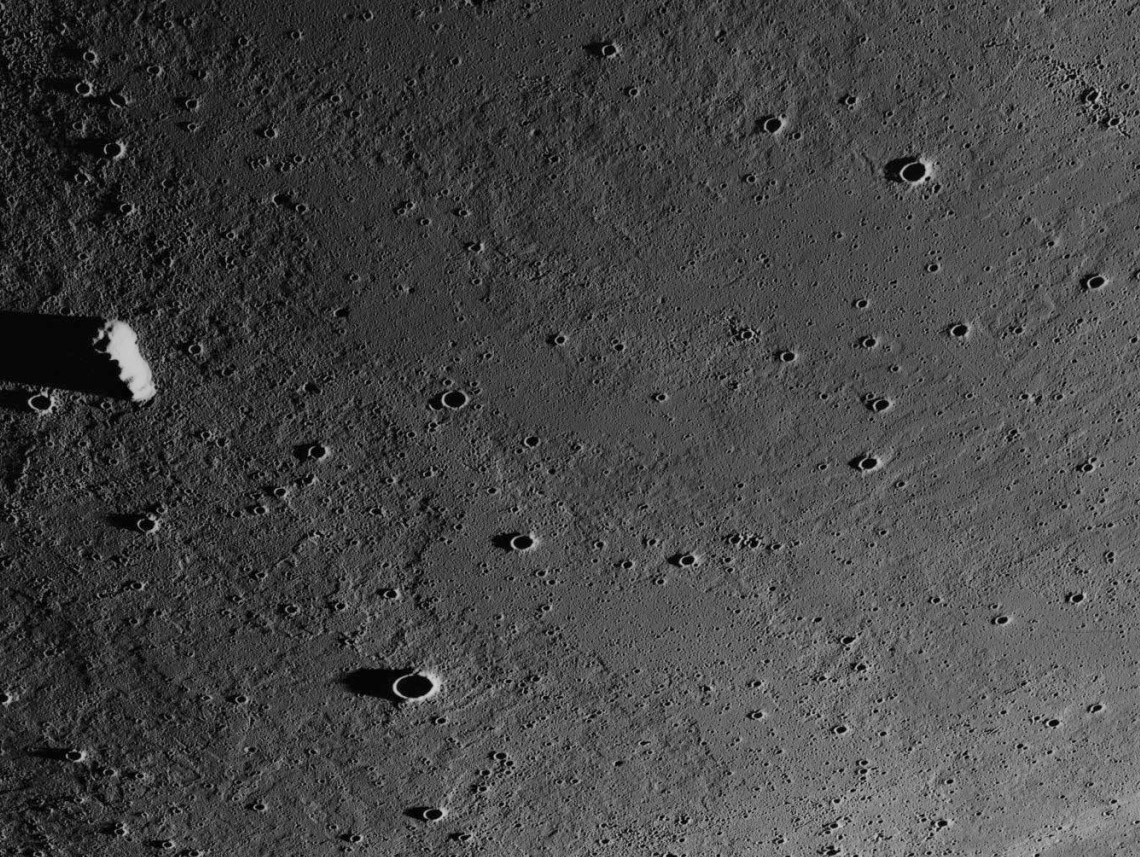
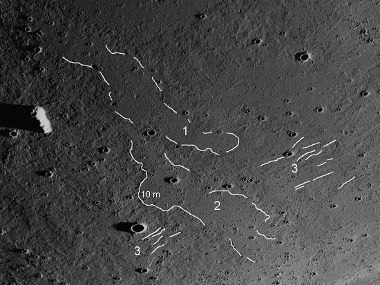
| − | <td>Very few lava flow fronts are known on the Moon; the most [ | + | <td>Very few lava flow fronts are known on the Moon; the most [[April_26,_2005|famous]] are those that flowed towards the center of Imbrium from near Mt. La Hire. But this 41 year old Apollo 15 Metric Camera image suggests that many other flows would be detected if we had high resolution, nearly grazing illumination for all maria. This area is about 85 km NE of Seleucus at 23.0°N, 64.5°W, and the scale is indicated by the 7 km long unnamed hill at center left. Different lava flows are indicated by elevated edges - as where a flow height of 10 m is marked, where fewer subsequent impact craters indicate a younger surface (as at 1), and where the surface has a different texture than nearby areas - at 1 and 2. An unknown number of flows are probably here but only the youngest - 1 and 2 - are easy to pick out. Interestingly, flow 2 crosses at nearly right angles a number of older, narrower flows - 3. QuickMap altimetry measurements show that the narrow flows slope downward from left to right about 40 m in 20 km. There is no consistent slope in the direction of flows 1 and 2. As is often the case when looking at closeup views of lava flows on Earth or the Moon I remember the conclusion of a volcanologist who studied a multi-year eruption at Mauna Ulu in Hawaii. He said that no one could correctly deduce the exact sequence of events unless they watched it, for emplacement of a lava flow field was unbelievably complex with many small differences in topography redirecting flows. |
<br /> | <br /> | ||
<em>[mailto:tychocrater@yahoo.com Chuck Wood]</em><br /> | <em>[mailto:tychocrater@yahoo.com Chuck Wood]</em><br /> | ||
<br /> | <br /> | ||
<strong>Related Links</strong><br /> | <strong>Related Links</strong><br /> | ||
| − | Rükl plate [ | + | Rükl plate [https://the-moon.us/wiki/R%C3%BCkl_17 17]<br /> |
</td> | </td> | ||
</tr> | </tr> | ||
| Line 21: | Line 22: | ||
<p><b>Tomorrow's LPOD:</b> [[August 10, 2012|Brown Flows, Dark Ash]] </p> | <p><b>Tomorrow's LPOD:</b> [[August 10, 2012|Brown Flows, Dark Ash]] </p> | ||
<hr /> | <hr /> | ||
| + | {{wiki/ArticleFooter}} | ||
Latest revision as of 17:44, 13 October 2018
More Flows

Apollo 15-M-2621 image from ASU Apollo Image Archive
 |
Very few lava flow fronts are known on the Moon; the most famous are those that flowed towards the center of Imbrium from near Mt. La Hire. But this 41 year old Apollo 15 Metric Camera image suggests that many other flows would be detected if we had high resolution, nearly grazing illumination for all maria. This area is about 85 km NE of Seleucus at 23.0°N, 64.5°W, and the scale is indicated by the 7 km long unnamed hill at center left. Different lava flows are indicated by elevated edges - as where a flow height of 10 m is marked, where fewer subsequent impact craters indicate a younger surface (as at 1), and where the surface has a different texture than nearby areas - at 1 and 2. An unknown number of flows are probably here but only the youngest - 1 and 2 - are easy to pick out. Interestingly, flow 2 crosses at nearly right angles a number of older, narrower flows - 3. QuickMap altimetry measurements show that the narrow flows slope downward from left to right about 40 m in 20 km. There is no consistent slope in the direction of flows 1 and 2. As is often the case when looking at closeup views of lava flows on Earth or the Moon I remember the conclusion of a volcanologist who studied a multi-year eruption at Mauna Ulu in Hawaii. He said that no one could correctly deduce the exact sequence of events unless they watched it, for emplacement of a lava flow field was unbelievably complex with many small differences in topography redirecting flows.
|
Yesterday's LPOD: What You Can Do From Earth
Tomorrow's LPOD: Brown Flows, Dark Ash
COMMENTS?
Register, Log in, and join in the comments.


