Difference between revisions of "September 25, 2014"
(Created page with "__NOTOC__ =Switching the High Side= <!-- ws:start:WikiTextHeadingRule:0:<h1> --> <!-- ws:start:WikiTextLocalImageRule:14:<img src="/file/view/LPOD-Sep25-14.j...") |
|||
| Line 2: | Line 2: | ||
=Switching the High Side= | =Switching the High Side= | ||
| − | + | <!-- ws:start:WikiTextHeadingRule:0:<h1> --> | |
| − | + | <!-- ws:start:WikiTextLocalImageRule:14:<img src="/file/view/LPOD-Sep25-14.jpg/523713596/LPOD-Sep25-14.jpg" alt="" title="" /> -->[[File:LPOD-Sep25-14.jpg|LPOD-Sep25-14.jpg]]<!-- ws:end:WikiTextLocalImageRule:14 --><br /> | |
<em>image by [mailto:raffaele.barzacchi@gmail.com Raffaele Barzacchi], Cogorno, Genoa, Italy</em><br /> | <em>image by [mailto:raffaele.barzacchi@gmail.com Raffaele Barzacchi], Cogorno, Genoa, Italy</em><br /> | ||
| − | |||
<table class="wiki_table"> | <table class="wiki_table"> | ||
| − | + | <tr> | |
| − | + | <td><!-- ws:start:WikiTextLocalImageRule:15:<img src="/file/view/LPOD-Sep25-14b.jpg/523713722/LPOD-Sep25-14b.jpg" alt="" title="" /> -->[[File:LPOD-Sep25-14b.jpg|LPOD-Sep25-14b.jpg]]<!-- ws:end:WikiTextLocalImageRule:15 --><br /> | |
</td> | </td> | ||
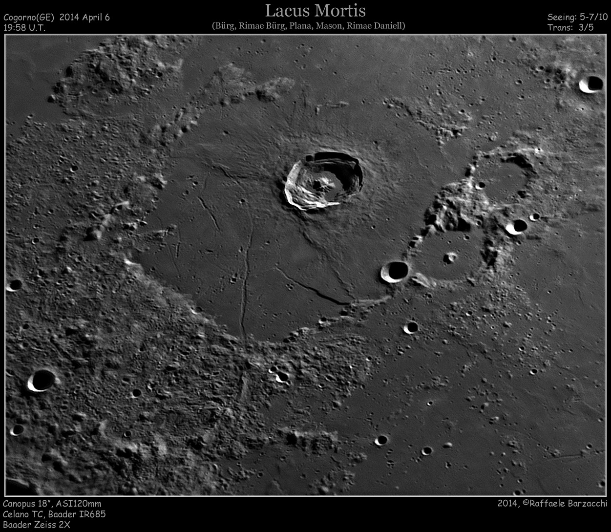
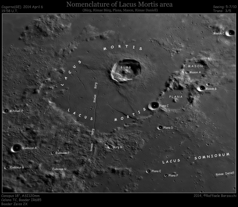
| − | + | <td>Lacus Mortis is a plain of lava that fills a crater with no name. And the most conspicuous floor feature is also unnamed, although often called the Bürg Fault, just as the nearby rille is the Bürg Rille. The LRO QuickMap altimetry tool shows that the right side of the fault rises about 350 m above the left side. Further down the feature, including beyond the sharp right angle turn, the high side switches to the left side, which rises about 60 m above the opposite side. Now look at the Bürg Rille in the area between the S in Lacus and the R in Rimae - near the top the right side is 60 m or so higher than the left, but down near where the S in Lacus is both sides of the rille are about the same height. In other words, the block of land between the fault and the rille is tilted up, with the side nearest Bürg being higher than the part closer to the Lacus Mortis crater rim. Now figuring out exactly why this happens will take more work, but LRO altimetry lets us map surface variations that otherwise we wouldn't be aware of. One other subtle feature in this area. Notice the light spot of the Lacus floor near the top end of the fault? On QuickMap that is [http://bit.ly/1pdQqUc seen] to be a patch of lava with fewer impact craters and a smoother surface than the other parts of the lacus. It is an awfully big deposit to be impact melt, and there is little evidence of much elsewhere, so it may be a younger lava flow that erupted from the thrust fault associated with the mare ridge that bounds it. <br /> | |
<br /> | <br /> | ||
<em>[mailto:tychocrater@yahoo.com Chuck Wood]</em><br /> | <em>[mailto:tychocrater@yahoo.com Chuck Wood]</em><br /> | ||
| Line 17: | Line 16: | ||
<em>[http://lpod.wikispaces.com/21st+Century+Atlas+of+the+Moon 21st Century Atlas]</em> chart 10.<br /> | <em>[http://lpod.wikispaces.com/21st+Century+Atlas+of+the+Moon 21st Century Atlas]</em> chart 10.<br /> | ||
</td> | </td> | ||
| − | + | </tr> | |
</table> | </table> | ||
| − | |||
<br /> | <br /> | ||
<hr /> | <hr /> | ||
| − | |||
| − | |||
| − | |||
| − | |||
| − | |||
Revision as of 01:08, 3 January 2015
Switching the High Side

image by Raffaele Barzacchi, Cogorno, Genoa, Italy
 |
Lacus Mortis is a plain of lava that fills a crater with no name. And the most conspicuous floor feature is also unnamed, although often called the Bürg Fault, just as the nearby rille is the Bürg Rille. The LRO QuickMap altimetry tool shows that the right side of the fault rises about 350 m above the left side. Further down the feature, including beyond the sharp right angle turn, the high side switches to the left side, which rises about 60 m above the opposite side. Now look at the Bürg Rille in the area between the S in Lacus and the R in Rimae - near the top the right side is 60 m or so higher than the left, but down near where the S in Lacus is both sides of the rille are about the same height. In other words, the block of land between the fault and the rille is tilted up, with the side nearest Bürg being higher than the part closer to the Lacus Mortis crater rim. Now figuring out exactly why this happens will take more work, but LRO altimetry lets us map surface variations that otherwise we wouldn't be aware of. One other subtle feature in this area. Notice the light spot of the Lacus floor near the top end of the fault? On QuickMap that is seen to be a patch of lava with fewer impact craters and a smoother surface than the other parts of the lacus. It is an awfully big deposit to be impact melt, and there is little evidence of much elsewhere, so it may be a younger lava flow that erupted from the thrust fault associated with the mare ridge that bounds it.
|


