Difference between revisions of "September 24, 2014"
| (5 intermediate revisions by the same user not shown) | |||
| Line 1: | Line 1: | ||
__NOTOC__ | __NOTOC__ | ||
=Black Splash= | =Black Splash= | ||
| + | <!-- Start of content --> | ||
<!-- ws:start:WikiTextHeadingRule:0:<h1> --> | <!-- ws:start:WikiTextHeadingRule:0:<h1> --> | ||
<!-- ws:start:WikiTextLocalImageRule:6:<img src="/file/view/LPOD-Sep24-14.jpg/523543560/LPOD-Sep24-14.jpg" alt="" title="" /> -->[[File:LPOD-Sep24-14.jpg|LPOD-Sep24-14.jpg]]<!-- ws:end:WikiTextLocalImageRule:6 --><br /> | <!-- ws:start:WikiTextLocalImageRule:6:<img src="/file/view/LPOD-Sep24-14.jpg/523543560/LPOD-Sep24-14.jpg" alt="" title="" /> -->[[File:LPOD-Sep24-14.jpg|LPOD-Sep24-14.jpg]]<!-- ws:end:WikiTextLocalImageRule:6 --><br /> | ||
| − | <em>image from [http://target.lroc.asu.edu/q3/# | + | <em>image from [http://target.lroc.asu.edu/q3/# LRO ACT-REACT QuickMap]</em><br /> |
<br /> | <br /> | ||
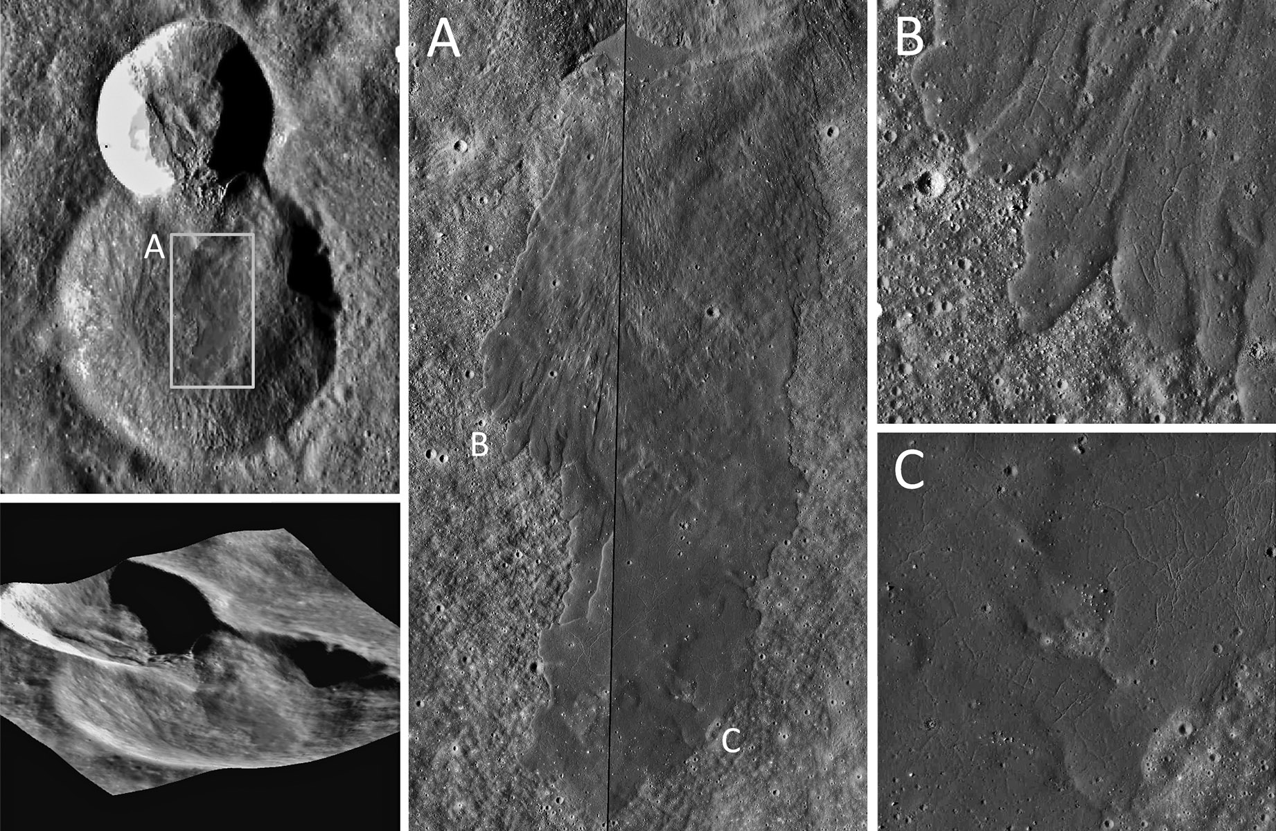
Korolev X is a well-worn, 26 km diameter crater on the lunar farside. Sometime after its formation a nearby impact dug a fresh 13 km diameter crater, breaching Korolev X’s northern wall and sending a tongue of debris tumbling onto its flat floor. Cascading down this debris is a 13 by 5 km sheet of dark and smooth impact melt, still showing the shrinkage cracks that formed as it cooled. The melt didn’t advance as a single flood, but rather on many glacier-like fronts, each several hundred meters across (B). As the melt spread onto Korolev X’s floor overlapping fronts wrapped around high points leaving kipuka-like islands of older more heavily-cratered terrain (C). Location: Latitude 0.56, Longitude -159.44<br /> | Korolev X is a well-worn, 26 km diameter crater on the lunar farside. Sometime after its formation a nearby impact dug a fresh 13 km diameter crater, breaching Korolev X’s northern wall and sending a tongue of debris tumbling onto its flat floor. Cascading down this debris is a 13 by 5 km sheet of dark and smooth impact melt, still showing the shrinkage cracks that formed as it cooled. The melt didn’t advance as a single flood, but rather on many glacier-like fronts, each several hundred meters across (B). As the melt spread onto Korolev X’s floor overlapping fronts wrapped around high points leaving kipuka-like islands of older more heavily-cratered terrain (C). Location: Latitude 0.56, Longitude -159.44<br /> | ||
<br /> | <br /> | ||
| − | [mailto:rsackett@memphis.edu | + | [mailto:rsackett@memphis.edu Ross Sackett], Memphis Astronomical Society<br /> |
<br /> | <br /> | ||
<strong>Technical Details</strong><br /> | <strong>Technical Details</strong><br /> | ||
| Line 13: | Line 14: | ||
<br /> | <br /> | ||
<strong>Related Links</strong><br /> | <strong>Related Links</strong><br /> | ||
| − | <em>[ | + | <em>[[21st Century Atlas of the Moon|21st Century Atlas]]</em> chart F2.<br /> |
<br /> | <br /> | ||
| + | <p><b>Yesterday's LPOD:</b> [[September 23, 2014|Pink and Grey Lavas]] </p> | ||
| + | <p><b>Tomorrow's LPOD:</b> [[September 25, 2014|Switching the High Side]] </p> | ||
<hr /> | <hr /> | ||
| + | {{wiki/ArticleFooter}} | ||
Latest revision as of 08:37, 28 October 2018
Black Splash

image from LRO ACT-REACT QuickMap
Korolev X is a well-worn, 26 km diameter crater on the lunar farside. Sometime after its formation a nearby impact dug a fresh 13 km diameter crater, breaching Korolev X’s northern wall and sending a tongue of debris tumbling onto its flat floor. Cascading down this debris is a 13 by 5 km sheet of dark and smooth impact melt, still showing the shrinkage cracks that formed as it cooled. The melt didn’t advance as a single flood, but rather on many glacier-like fronts, each several hundred meters across (B). As the melt spread onto Korolev X’s floor overlapping fronts wrapped around high points leaving kipuka-like islands of older more heavily-cratered terrain (C). Location: Latitude 0.56, Longitude -159.44
Ross Sackett, Memphis Astronomical Society
Technical Details
Images from Lunar Reconnaissance Orbiter wide-angle and narrow-angle cameras. 3D visualization using the PIPE 3D Live tool. Images processed in Photoshop to improve contrast.
Related Links
21st Century Atlas chart F2.
Yesterday's LPOD: Pink and Grey Lavas
Tomorrow's LPOD: Switching the High Side
COMMENTS?
Register, Log in, and join in the comments.


