|
|
| (5 intermediate revisions by the same user not shown) |
| Line 1: |
Line 1: |
| | __NOTOC__ | | __NOTOC__ |
| | =Bullialdus’ Bridge= | | =Bullialdus’ Bridge= |
| | + | <!-- Start of content --> |
| | <div class="post" id="post-571"> | | <div class="post" id="post-571"> |
| | | | |
| Line 6: |
Line 7: |
| | <p>[[File:Bullialdus_valleyLPOD.jpg|bullialdus_valleyLPOD.jpg]]<br /> | | <p>[[File:Bullialdus_valleyLPOD.jpg|bullialdus_valleyLPOD.jpg]]<br /> |
| | <em>drawing by [mailto:harry128@ozemail.com.au Harry Roberts]</em></p> | | <em>drawing by [mailto:harry128@ozemail.com.au Harry Roberts]</em></p> |
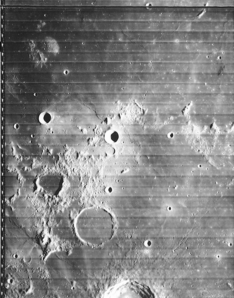
| − | <p>Maria are not flat, they drape underlying features, smoothing them out, making detection and interpretation difficult. That is why its fun looking near the terminator when it is near a mare surface. Harry became fascinated with features on, under? above? Mare Nubium west of Bullialdus. He notes a causeway (on Earth an elevated passageway) and wondered what caused it. Rükl noted the causeway in his <em>Atlas of the Moon</em> and a number of observers have commented on it, but what is it? The first thing to note is that the causeway seems to span a broad linear depression that strangely has a designation: Bullialdus W. Lunar Orbiter IV [[iv_125_h2.jpg|shows]] that this trough is bounded on both sides by low mare ridges which define the linear area, but there could be no actual depression. A <em>Consolidated Lunar Atlas</em> [http://www.lpod.org/coppermine/displayimage.php?pid=463&fullsize=1 image] suggests that the south (bottom) side of the trough is actually a broad, flattish mare ridge. By now you may have forgotten about the causeway, which is good, because I have no idea what it is.</p> | + | <p>Maria are not flat, they drape underlying features, smoothing them out, making detection and interpretation difficult. That is why its fun looking near the terminator when it is near a mare surface. Harry became fascinated with features on, under? above? Mare Nubium west of Bullialdus. He notes a causeway (on Earth an elevated passageway) and wondered what caused it. Rükl noted the causeway in his <em>Atlas of the Moon</em> and a number of observers have commented on it, but what is it? The first thing to note is that the causeway seems to span a broad linear depression that strangely has a designation: Bullialdus W. Lunar Orbiter IV [http://www.lpi.usra.edu/resources/lunar_orbiter/images/img/iv_125_h2.jpg shows] that this trough is bounded on both sides by low mare ridges which define the linear area, but there could be no actual depression. A <em>Consolidated Lunar Atlas</em> [http://www.lpod.org/coppermine/displayimage.php?pid=463&fullsize=1 image] suggests that the south (bottom) side of the trough is actually a broad, flattish mare ridge. By now you may have forgotten about the causeway, which is good, because I have no idea what it is.</p> |
| | <p>[mailto:tychocrater@yahoo.com Chuck Wood]</p> | | <p>[mailto:tychocrater@yahoo.com Chuck Wood]</p> |
| | <p><strong>Technical Details:</strong><br /> | | <p><strong>Technical Details:</strong><br /> |
| − | 16 July 2005. C8 at 160X. See the [http://www.lpod.org/?m=20060201 Feb 1] LPOD for a description of Harry’s artistic techniques.<br /> | + | 16 July 2005. C8 at 160X. See the [[February_1,_2006|Feb 1]] LPOD for a description of Harry’s artistic techniques.<br /> |
| | <strong>Related Links:</strong><br /> | | <strong>Related Links:</strong><br /> |
| | Rükl chart 53<br /> | | Rükl chart 53<br /> |
| | <em>Consolidated Lunar Atlas </em>[http://www.lpod.org/coppermine/displayimage.php?album=4&pos=20 view]</p> | | <em>Consolidated Lunar Atlas </em>[http://www.lpod.org/coppermine/displayimage.php?album=4&pos=20 view]</p> |
| − | <p align="center"><em>Now you can support LPOD when you buy ANY book from Amazon thru [http://www.lpod.org/?page_id=102 LPOD!]</em></p> | + | <p><b>Yesterday's LPOD:</b> [[September 22, 2006|Hell Plain]] </p> |
| | + | <p><b>Tomorrow's LPOD:</b> [[September 24, 2006|Ramadan]] </p> |
| | + | <!-- Removed reference to store page 2 --> |
| | </div> | | </div> |
| − | ---- | + | <!-- End of content --> |
| − | ===COMMENTS?===
| + | {{wiki/ArticleFooter}} |
| − | Register, and click on the <b>Discussion</b> tab at the top of the page.
| |


