Difference between revisions of "September 20, 2013"
| Line 3: | Line 3: | ||
<!-- ws:start:WikiTextHeadingRule:0:<h1> --> | <!-- ws:start:WikiTextHeadingRule:0:<h1> --> | ||
<!-- ws:start:WikiTextLocalImageRule:6:<img src="/file/view/LPOD-Sept20-13.jpg/452602694/LPOD-Sept20-13.jpg" alt="" title="" /> -->[[File:LPOD-Sept20-13.jpg|LPOD-Sept20-13.jpg]]<!-- ws:end:WikiTextLocalImageRule:6 --><br /> | <!-- ws:start:WikiTextLocalImageRule:6:<img src="/file/view/LPOD-Sept20-13.jpg/452602694/LPOD-Sept20-13.jpg" alt="" title="" /> -->[[File:LPOD-Sept20-13.jpg|LPOD-Sept20-13.jpg]]<!-- ws:end:WikiTextLocalImageRule:6 --><br /> | ||
| − | <em>image by [mailto:howardeskildsen@msn.com | + | <em>image by [mailto:howardeskildsen@msn.com Howard Eskildsen], Ocala, Florida</em><br /> |
<br /> | <br /> | ||
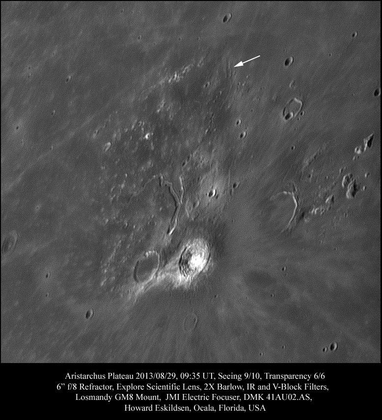
Notice the distinct trapezoidal-shaped area near the center of the image with Aristarchus at the lower right corner? It appears pummeled, pocked, and burnished, but never overflowed by lava like the surrounding terrain. The Schröter Valley, which courses through the lower center of the plateau and then angles away to the left, marks the final course of lava that once flowed from the "Cobra’s Head" source. But did it always flow that way? I doubt it. Look at the scarp to the right of the midcourse of the valley. Might that have been part of the lateral wall of the flow sometime in the past, and might the main channel once have poured over to the upper right side of the plateau? If so, imagine the changes in elevation that would eventually turn the massive flow in another direction, and ponder why those elevation changes may have occurred. Perhaps asymmetrical collapse of the plateau as molten material flowed out from below? Finally notice the short parallel markings north of Aristarchus at the northeast corner of the plateau (see arrow). This is almost certainly a flow channel remnant (check it out on the LROC Act-React QuickMap). Might the Cobra’s Head region have been the original source that carved this channel 170 km away, or was there another flow source, now buried from view?<br /> | Notice the distinct trapezoidal-shaped area near the center of the image with Aristarchus at the lower right corner? It appears pummeled, pocked, and burnished, but never overflowed by lava like the surrounding terrain. The Schröter Valley, which courses through the lower center of the plateau and then angles away to the left, marks the final course of lava that once flowed from the "Cobra’s Head" source. But did it always flow that way? I doubt it. Look at the scarp to the right of the midcourse of the valley. Might that have been part of the lateral wall of the flow sometime in the past, and might the main channel once have poured over to the upper right side of the plateau? If so, imagine the changes in elevation that would eventually turn the massive flow in another direction, and ponder why those elevation changes may have occurred. Perhaps asymmetrical collapse of the plateau as molten material flowed out from below? Finally notice the short parallel markings north of Aristarchus at the northeast corner of the plateau (see arrow). This is almost certainly a flow channel remnant (check it out on the LROC Act-React QuickMap). Might the Cobra’s Head region have been the original source that carved this channel 170 km away, or was there another flow source, now buried from view?<br /> | ||
<br /> | <br /> | ||
| − | <em>[mailto:howardeskildsen@msn.com | + | <em>[mailto:howardeskildsen@msn.com Howard Eskildsen]</em><br /> |
<br /> | <br /> | ||
<strong>Related Links</strong><br /> | <strong>Related Links</strong><br /> | ||
Revision as of 18:09, 11 January 2015
A New Theory

image by Howard Eskildsen, Ocala, Florida
Notice the distinct trapezoidal-shaped area near the center of the image with Aristarchus at the lower right corner? It appears pummeled, pocked, and burnished, but never overflowed by lava like the surrounding terrain. The Schröter Valley, which courses through the lower center of the plateau and then angles away to the left, marks the final course of lava that once flowed from the "Cobra’s Head" source. But did it always flow that way? I doubt it. Look at the scarp to the right of the midcourse of the valley. Might that have been part of the lateral wall of the flow sometime in the past, and might the main channel once have poured over to the upper right side of the plateau? If so, imagine the changes in elevation that would eventually turn the massive flow in another direction, and ponder why those elevation changes may have occurred. Perhaps asymmetrical collapse of the plateau as molten material flowed out from below? Finally notice the short parallel markings north of Aristarchus at the northeast corner of the plateau (see arrow). This is almost certainly a flow channel remnant (check it out on the LROC Act-React QuickMap). Might the Cobra’s Head region have been the original source that carved this channel 170 km away, or was there another flow source, now buried from view?
Howard Eskildsen
Related Links
21st Century Atlas chart 28.


