Difference between revisions of "October 30, 2012"
| Line 33: | Line 33: | ||
<br /> | <br /> | ||
<hr /> | <hr /> | ||
| + | <!-- Removed reference to store page --> | ||
| + | </div> | ||
| + | ---- | ||
| + | ===COMMENTS?=== | ||
| + | Register, and click on the <b>Discussion</b> tab at the top of the page. | ||
| + | <hr> | ||
| + | You can support LPOD when you buy any book from Amazon thru [[Support_ LPOD|LPOD]]! | ||
| + | <span style="font-size:88%"> | ||
| + | <center> | ||
| + | Contributions to http://www2.lpod.org/ are licensed under a Creative Commons Attribution No-Derivative-Works Non-Commercial 3.0 License. [http://www.creativecommons.org/licenses/by-nc-nd/3.0 http://www.wikispaces.com/i/creativecommons/by-nc-nd_3.0_80x15.png]<br> | ||
| + | </center> | ||
| + | </span> | ||
Revision as of 20:15, 31 January 2015
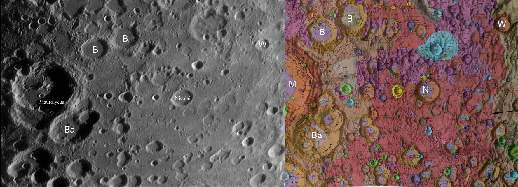
Pitted Plains

image by Howard Eskildsen and US Geological Survey map from LPI's Lunar Map Collection. B and B = Buch and Büsching, Ba = Barocius,
M = Maurolycus, N = Nicoli, W = Wöhler.
In the late 1950s Gene Shoemaker, Bob Hackmann and other scientists at the US Geological Survey applied familiar mapping principals to
determine the sequence of events on the Moon. The unusual aspects of their work was that no geologists had been on the lunar surace to
examine closely the relationships between rock units, look for fossils and other clues that guide terrestril mapping. Shoemaker recognized
that many landforms could be seen to be covered by ejecta from impact craters and basins or else sat on top of the ejecta. His classic ex-
ample was the Copernicus area where that craters rays crossed Mare Imbrium and even Eratosthenes, both of which must be older. The Sur-
vey ultimately mapped the entire Moon and for each area they characterized the morphology of the surface and provided an interpretation
of its origin. Back in the 60s it was assumed that volcanism occured both as mare lava flows and as widespread pyroclastic or ash flows.
Many relatively smooth materials that weren't dark like maria - such as the flat floors of highland craters and the spaces between such craters
- were interpreted as volcanic ash. Howard has matched one of his images with a 1972 vintage Survey geologic map of the Moon's southern
highlands west of Janssen. The pinkish area indicated with the black arrow on the right was called "pitted plains" because of its relatively
smooth surface pitted with small craterlets. These plains were interpreted as volcanic lavas or pyroclastics. Today we still don't know what
the smooth matierals are but spectral data show no evidence for volcanic materials like the maria or lighter volcanic matierals such as the
Gruithuisen domes. The general interpretation is that such light-hued smoothish plains are fluidized ejecta from the formation of the Imbrium
and other basins. Who knows, they might be. This region has also been speculated to be within an ancient impact basin called Mutus-Vlacq.
I like it that Howard has used his images to document an unusual area identified from the most comprehesive geologic mapping ever done
for the Moon.
Chuck Wood
Technical Details
Oct 22, 2012, 00:21 UT. 6" f/8 refractor, Explore Scientific lens + 2X Barlow + IR + V-block filters + DMK41AU02.AS + Losmandy GM8 mount
+ JMI electric focuser.
Related Links
Rükl plate 67
COMMENTS?
Register, and click on the Discussion tab at the top of the page.
You can support LPOD when you buy any book from Amazon thru LPOD!
Contributions to http://www2.lpod.org/ are licensed under a Creative Commons Attribution No-Derivative-Works Non-Commercial 3.0 License. 


