Difference between revisions of "October 29, 2004"
| Line 12: | Line 12: | ||
</table> | </table> | ||
<table width="80%" border="0" align="center" cellpadding="8"> | <table width="80%" border="0" align="center" cellpadding="8"> | ||
| − | <tr><td><div align="center" class="main_sm">Image Credit: [mailto:Alexander.Vandenbohede@UGent.be Alexander Vandenbohede]</p> | + | <tr><td><div align="center" class="main_sm"><p>Image Credit: [mailto:Alexander.Vandenbohede@UGent.be Alexander Vandenbohede]</p> |
</div></td> | </div></td> | ||
</tr> | </tr> | ||
| Line 21: | Line 21: | ||
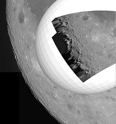
<p align="left">Inspired by J-P [[June_21,_2004| Metsavainio's]] use of Photoshop software to digitally rectify images of the lunar limb, Alexander Vandenbohede of Belgium applied the technique to one of his images of the Orientale basin. The composite image above shows Alexander's original telescopic image and the inset image shows the same image after rectification. The golf ball is the digital sphere that the image was mapped onto. The result beautifully reveals the concentric rings of the Orientale basin. This is the same view that led to the discovery in the early 1960s by Bill Hartmann that Orientale was a multi-ring impact basin. The outer ring is the Cordillera Mountains and the two inner ones are the Inner and Outer Rook Mountains - see the Lunar Orbiter [[March_18,_2004|view]] of the entire structure for a clarification. In 1963, Hartmann and colleagues at the Lunar & Planetary Lab in Tucson created a <i>Rectified Lunar Atlas</i> - now amateurs can do the same!</p> | <p align="left">Inspired by J-P [[June_21,_2004| Metsavainio's]] use of Photoshop software to digitally rectify images of the lunar limb, Alexander Vandenbohede of Belgium applied the technique to one of his images of the Orientale basin. The composite image above shows Alexander's original telescopic image and the inset image shows the same image after rectification. The golf ball is the digital sphere that the image was mapped onto. The result beautifully reveals the concentric rings of the Orientale basin. This is the same view that led to the discovery in the early 1960s by Bill Hartmann that Orientale was a multi-ring impact basin. The outer ring is the Cordillera Mountains and the two inner ones are the Inner and Outer Rook Mountains - see the Lunar Orbiter [[March_18,_2004|view]] of the entire structure for a clarification. In 1963, Hartmann and colleagues at the Lunar & Planetary Lab in Tucson created a <i>Rectified Lunar Atlas</i> - now amateurs can do the same!</p> | ||
<blockquote> | <blockquote> | ||
| − | <p align="right">— [mailto:tychocrater@yahoo.com Chuck Wood]</blockquote> | + | <p align="right">— [mailto:tychocrater@yahoo.com Chuck Wood]</p></blockquote> |
<p align="left"><b>Technical Details:</b><br> | <p align="left"><b>Technical Details:</b><br> | ||
April 4, 2004 at 2200 UT with a 20 cm F6 Dobson.</p> | April 4, 2004 at 2200 UT with a 20 cm F6 Dobson.</p> | ||
| Line 27: | Line 27: | ||
[http://observingthesky.org/index.php?p=90 Hartmann's Discovery of Orientale Rings] | [http://observingthesky.org/index.php?p=90 Hartmann's Discovery of Orientale Rings] | ||
<br>[http://observingthesky.org/index.php?p=90Astronom Rectified Lunar Atlas] | <br>[http://observingthesky.org/index.php?p=90Astronom Rectified Lunar Atlas] | ||
| + | </p> | ||
<p align="left"><b>Tomorrow's LPOD: </b> Another Basin on Another Limb</p> | <p align="left"><b>Tomorrow's LPOD: </b> Another Basin on Another Limb</p> | ||
</tr> | </tr> | ||
Revision as of 20:51, 17 January 2015
Unscrunching Orientale
Image Credit: Alexander Vandenbohede |
|
Unscrunching Orientale Inspired by J-P Metsavainio's use of Photoshop software to digitally rectify images of the lunar limb, Alexander Vandenbohede of Belgium applied the technique to one of his images of the Orientale basin. The composite image above shows Alexander's original telescopic image and the inset image shows the same image after rectification. The golf ball is the digital sphere that the image was mapped onto. The result beautifully reveals the concentric rings of the Orientale basin. This is the same view that led to the discovery in the early 1960s by Bill Hartmann that Orientale was a multi-ring impact basin. The outer ring is the Cordillera Mountains and the two inner ones are the Inner and Outer Rook Mountains - see the Lunar Orbiter view of the entire structure for a clarification. In 1963, Hartmann and colleagues at the Lunar & Planetary Lab in Tucson created a Rectified Lunar Atlas - now amateurs can do the same! Technical Details: Related Links: Tomorrow's LPOD: Another Basin on Another Limb |
|
Author & Editor: Technical Consultant: Contact Translator: A service of: |
COMMENTS?
Register, and click on the Discussion tab at the top of the page.


