Difference between revisions of "November 16, 2009"
| (2 intermediate revisions by the same user not shown) | |||
| Line 1: | Line 1: | ||
__NOTOC__ | __NOTOC__ | ||
=Long Radials= | =Long Radials= | ||
| + | <!-- Start of content --> | ||
<!-- ws:start:WikiTextHeadingRule:1:<h1> --> | <!-- ws:start:WikiTextHeadingRule:1:<h1> --> | ||
<!-- ws:start:WikiTextLocalImageRule:16:<img src="/file/view/LPOD-Nov16-09.jpg/102834785/LPOD-Nov16-09.jpg" alt="" title="" /> -->[[File:LPOD-Nov16-09.jpg|LPOD-Nov16-09.jpg]]<!-- ws:end:WikiTextLocalImageRule:16 --><br /> | <!-- ws:start:WikiTextLocalImageRule:16:<img src="/file/view/LPOD-Nov16-09.jpg/102834785/LPOD-Nov16-09.jpg" alt="" title="" /> -->[[File:LPOD-Nov16-09.jpg|LPOD-Nov16-09.jpg]]<!-- ws:end:WikiTextLocalImageRule:16 --><br /> | ||
<em>image by [mailto:mauricejscollins@hotmail.com Maurice Collins]</em><br /> | <em>image by [mailto:mauricejscollins@hotmail.com Maurice Collins]</em><br /> | ||
<br /> | <br /> | ||
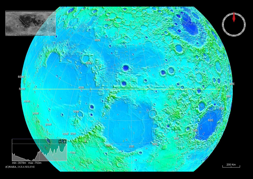
| − | Maurice has been using the new visualization [ | + | Maurice has been using the new visualization [[November_12,_2009|tool]] to explore Kaguya topography to look at features radial to the Imbrium Basin. First he centered the view on Imbrium to get a basin overview and then he rotated the globe so that the yellow line marking the topography trace lined up with various radial features. In this view the yellow line traces the huge offset between the Caucasus and the Alpes just north of Cassini. The topography reveals an extension of that radial direction to the right as an otherwise unnoticeable linear mountain edge that runs from near Leméch to east, southeast of Eudoxus. After a gap, the topographic linear feature continues as a line of hills between Bürg and Grove. Until seeing Maurice's oriented image with the yellow line I never noticed that the line of the Caucusus-Alpes offset continues about 700 km roughly eastwards. If you look at the Alpine Valley you'll see similar topographic hints that it extends radially away from Imbrium for another 200 or so kilometers. This high resolution topo data set - and the even better one to come soon from LRO - will reveal all sorts of unsuspected features of the Moon. For example, notice the steady decrease in elevation across the Imbrium Basin - the left third of the topo cross-section at bottom left - amazing!<br /> |
<br /> | <br /> | ||
<em>[mailto:tychocrater@yahoo.com Chuck Wood]</em><br /> | <em>[mailto:tychocrater@yahoo.com Chuck Wood]</em><br /> | ||
<br /> | <br /> | ||
| + | <p><b>Yesterday's LPOD:</b> [[November 15, 2009|Hills, Troughs And a Collapse]] </p> | ||
| + | <p><b>Tomorrow's LPOD:</b> [[November 17, 2009|Destination Moon]] </p> | ||
<hr /> | <hr /> | ||
| − | < | + | <table class="wiki_table"> |
| − | < | + | <tr> |
| − | ---- | + | <td> <!-- RemoveRevolverMaps --> |
| − | + | <!-- RemoveRevolverMaps --> | |
| − | + | </td> | |
| + | <!-- End of content --> | ||
| + | {{wiki/ArticleFooter}} | ||
Latest revision as of 20:47, 8 February 2015
Long Radials

image by Maurice Collins
Maurice has been using the new visualization tool to explore Kaguya topography to look at features radial to the Imbrium Basin. First he centered the view on Imbrium to get a basin overview and then he rotated the globe so that the yellow line marking the topography trace lined up with various radial features. In this view the yellow line traces the huge offset between the Caucasus and the Alpes just north of Cassini. The topography reveals an extension of that radial direction to the right as an otherwise unnoticeable linear mountain edge that runs from near Leméch to east, southeast of Eudoxus. After a gap, the topographic linear feature continues as a line of hills between Bürg and Grove. Until seeing Maurice's oriented image with the yellow line I never noticed that the line of the Caucusus-Alpes offset continues about 700 km roughly eastwards. If you look at the Alpine Valley you'll see similar topographic hints that it extends radially away from Imbrium for another 200 or so kilometers. This high resolution topo data set - and the even better one to come soon from LRO - will reveal all sorts of unsuspected features of the Moon. For example, notice the steady decrease in elevation across the Imbrium Basin - the left third of the topo cross-section at bottom left - amazing!
Chuck Wood
Yesterday's LPOD: Hills, Troughs And a Collapse
Tomorrow's LPOD: Destination Moon
COMMENTS?
Register, Log in, and join in the comments.


