Difference between revisions of "May 5, 2012"
| Line 24: | Line 24: | ||
<br /> | <br /> | ||
<hr /> | <hr /> | ||
| + | <!-- Removed reference to store page --> | ||
| + | </div> | ||
| + | ---- | ||
| + | ===COMMENTS?=== | ||
| + | Register, and click on the <b>Discussion</b> tab at the top of the page. | ||
| + | <hr> | ||
| + | You can support LPOD when you buy any book from Amazon thru [[Support_ LPOD|LPOD]]! | ||
| + | <span style="font-size:88%"> | ||
| + | <center> | ||
| + | Contributions to http://www2.lpod.org/ are licensed under a Creative Commons Attribution No-Derivative-Works Non-Commercial 3.0 License. [http://www.creativecommons.org/licenses/by-nc-nd/3.0 http://www.wikispaces.com/i/creativecommons/by-nc-nd_3.0_80x15.png]<br> | ||
| + | </center> | ||
| + | </span> | ||
Revision as of 20:07, 31 January 2015
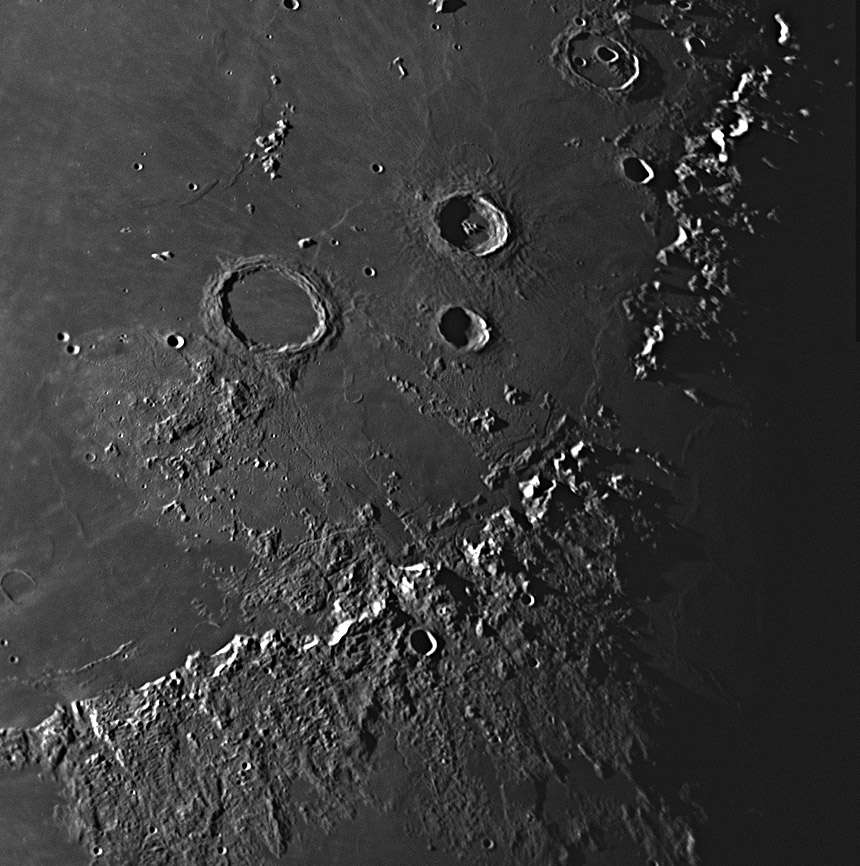
Two Modest Proposals

image by [mailto: Dave Storey], Isle of Man
 |
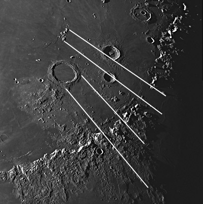
Here is an outrageous suggestion, in fact, two of them. The piece of the Imbrium Basin floor that Archimedes formed on slid about 150 km to the west where we find it today. It has been there a long time, because the surrounding mare lavas erupted about 3.5 billion years. The displacement of that piece of crust helps explain the existence of Palus Putredinis, the oblong of lava that fills the path that Archimedes is posited to have travelled. The smaller image includes white lines that mark the shear zones, still preserved, that bounded the movement. Additionally, the Hadley Rille lava channel has its origin at a vent near the southern boundary, a fault that may have facilitated rise of magma to the surface, and its well-defined length extends to the northern boundary. The rilles that parallel the Apeninne Front and cuts through the old Apennine Bench Formation are interupted by the younger lavas of Palus Putredinis. A topo trace across the Palus using the LRO QuickMap Path tool demonstrates that is is about 300 m lower than the zones to northeast and southwest. Since this wild-eye idea seems to be explain some observations lets make a wilder claim. The Spitzbergen Mountains are a piece of the Apennine Front that similarly slide in a giant sliver of basin floor about 300 km to the west-northwest. The displacement of these mountains explains the gap in the mountain rim of the basin where Imbrium and Serenitatis lavas merge. I have previous speculated that these Straits of Fresnel formed by subsidence, and now am suggesting that the movement may have been lateral. If Spitsbergen had such a translational origin, how about Piton, Pico, the Teneriffe Mountains and the Straight Range? Bill Hartmann and I argued 4o years ago that these mountains are the tops of impact basin inner rings such as seen in other less deeptly flooded basins, and they may be. But if basins had large scale sliding of material towards their centers - as smaller craters do with terraces and slumps - these pieces of Imbrium rim and floor may have slid coherently inward until they were stopped by the basin inner ring ridges. That could explain why the mountains are often displaced from the mare ridges that more completely mark inner rims. |
Technical Details
08/31/2010 03.33 - 04.05h UT. 16" SCT + Image Source Camera DBK41AG02.AS
Related Links
Rükl plate 22
COMMENTS?
Register, and click on the Discussion tab at the top of the page.
You can support LPOD when you buy any book from Amazon thru LPOD!
Contributions to http://www2.lpod.org/ are licensed under a Creative Commons Attribution No-Derivative-Works Non-Commercial 3.0 License. 


