Difference between revisions of "May 4, 2013"
| Line 2: | Line 2: | ||
=Topographic Revelations= | =Topographic Revelations= | ||
| − | + | <!-- ws:start:WikiTextHeadingRule:0:<h1> --> | |
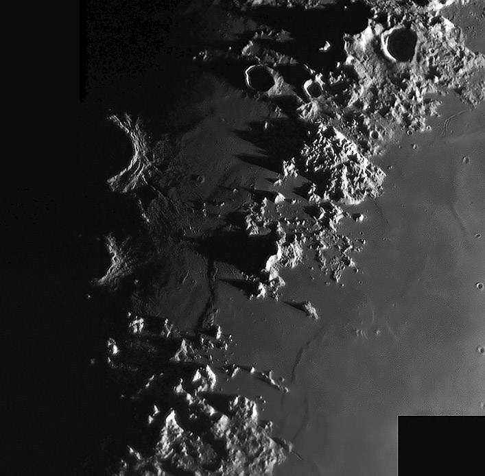
| − | + | <!-- ws:start:WikiTextLocalImageRule:14:<img src="/file/view/LPOD-MAY4-13.jpg/428740806/LPOD-MAY4-13.jpg" alt="" title="" /> -->[[File:LPOD-MAY4-13.jpg|LPOD-MAY4-13.jpg]]<!-- ws:end:WikiTextLocalImageRule:14 --><br /> | |
<em>image by [mailto:maximoeselmasguapo@hotmail.com Jose Cabello], Málaga, Spain</em><br /> | <em>image by [mailto:maximoeselmasguapo@hotmail.com Jose Cabello], Málaga, Spain</em><br /> | ||
| − | |||
<table class="wiki_table"> | <table class="wiki_table"> | ||
| − | + | <tr> | |
| − | + | <td><!-- ws:start:WikiTextLocalImageRule:15:<img src="/file/view/LPOD-MAY4-13B.jpg/428743522/LPOD-MAY4-13B.jpg" alt="" title="" /> -->[[File:LPOD-MAY4-13B.jpg|LPOD-MAY4-13B.jpg]]<!-- ws:end:WikiTextLocalImageRule:15 --><br /> | |
</td> | </td> | ||
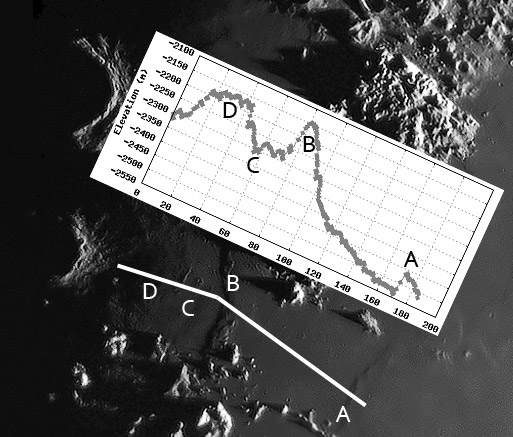
| − | + | <td>Jose's terminator view of the [http://lpod.wikispaces.com/January+29,+2010 Straits of Fresnel] - my informal name for the lava passage between Mare Serenitatis on the right and the edge of Mare Imbrium on the left - depicts the subtle ridges creasing the lavas. In looking at the Straits I had always interpreted the scene as lava that been cooled in place while flowing from east to west. The reason for thinking that the flow was in that direction is that the two mare ridges - A and B on the image with a LRO QuickMap topography trace - have their gentle slopes on the east and steep ones to the west. I had it completely backwards - the slope is from high in the west to low in the east. In fact, to the east of A the surface continues to tilt downward towards the center of Serenitatis. The cross section of ridge A (named Gast Ridge) illustrates that it fairly abruptly (but not like the Straight Wall) drops down about 75 m. This implies that the ridge is a low angle thrust fault. As the solidified pile of Serenitatis lava subsided it fractured parallel to the shore and the eastern piece of the maria slide sideways up over the western lavas. Moving toward ridge B the elevation increases about 400 m before dropping 150 m on the west side of B; on the image that drop is indicated by the shadows. The B ridge may be a continuation of the Apennine Front, the abrupt fault scarp where the Apennines rise above Imbrium lavas to the west. A very shallow trough at C seems to be the lava-covered continuation of the Fresnel Rille. Interestingly, between C and the rim of Autolycus is 130 m high plateau. This might be a buried continuation of the two mountains between D and the bottom left corner of the image. Another of my interpretations is that the missing rim marked by the Straits of Fresnel subsided and the area was covered by later lavas. That is still consistent with what we observe. <br /> | |
<br /> | <br /> | ||
<em>[mailto:tychocrater@yahoo.com Chuck Wood]</em><br /> | <em>[mailto:tychocrater@yahoo.com Chuck Wood]</em><br /> | ||
| Line 17: | Line 16: | ||
04/017/2013. C11 and dmk21au618.<br /> | 04/017/2013. C11 and dmk21au618.<br /> | ||
</td> | </td> | ||
| − | + | </tr> | |
</table> | </table> | ||
| − | |||
<br /> | <br /> | ||
<strong>Related Links</strong><br /> | <strong>Related Links</strong><br /> | ||
| Line 26: | Line 24: | ||
<br /> | <br /> | ||
<hr /> | <hr /> | ||
| − | |||
| − | |||
| − | |||
| − | |||
| − | |||
Revision as of 00:46, 3 January 2015
Topographic Revelations

image by Jose Cabello, Málaga, Spain
 |
Jose's terminator view of the Straits of Fresnel - my informal name for the lava passage between Mare Serenitatis on the right and the edge of Mare Imbrium on the left - depicts the subtle ridges creasing the lavas. In looking at the Straits I had always interpreted the scene as lava that been cooled in place while flowing from east to west. The reason for thinking that the flow was in that direction is that the two mare ridges - A and B on the image with a LRO QuickMap topography trace - have their gentle slopes on the east and steep ones to the west. I had it completely backwards - the slope is from high in the west to low in the east. In fact, to the east of A the surface continues to tilt downward towards the center of Serenitatis. The cross section of ridge A (named Gast Ridge) illustrates that it fairly abruptly (but not like the Straight Wall) drops down about 75 m. This implies that the ridge is a low angle thrust fault. As the solidified pile of Serenitatis lava subsided it fractured parallel to the shore and the eastern piece of the maria slide sideways up over the western lavas. Moving toward ridge B the elevation increases about 400 m before dropping 150 m on the west side of B; on the image that drop is indicated by the shadows. The B ridge may be a continuation of the Apennine Front, the abrupt fault scarp where the Apennines rise above Imbrium lavas to the west. A very shallow trough at C seems to be the lava-covered continuation of the Fresnel Rille. Interestingly, between C and the rim of Autolycus is 130 m high plateau. This might be a buried continuation of the two mountains between D and the bottom left corner of the image. Another of my interpretations is that the missing rim marked by the Straits of Fresnel subsided and the area was covered by later lavas. That is still consistent with what we observe.
|
Related Links
Rükl plate 12 & 23
21st Century Atlas chart 11 & B5.


