Difference between revisions of "May 2, 2010"
| (7 intermediate revisions by the same user not shown) | |||
| Line 1: | Line 1: | ||
__NOTOC__ | __NOTOC__ | ||
=Concatenation= | =Concatenation= | ||
| − | + | <!-- Start of content --> | |
<!-- ws:start:WikiTextHeadingRule:1:<h1> --> | <!-- ws:start:WikiTextHeadingRule:1:<h1> --> | ||
<!-- ws:start:WikiTextLocalImageRule:16:<img src="/file/view/LPOD-May2-10.jpg/138657397/LPOD-May2-10.jpg" alt="" title="" style="width: 1100px;" /> -->[[File:LPOD-May2-10.jpg|LPOD-May2-10.jpg]]<!-- ws:end:WikiTextLocalImageRule:16 --><br /> | <!-- ws:start:WikiTextLocalImageRule:16:<img src="/file/view/LPOD-May2-10.jpg/138657397/LPOD-May2-10.jpg" alt="" title="" style="width: 1100px;" /> -->[[File:LPOD-May2-10.jpg|LPOD-May2-10.jpg]]<!-- ws:end:WikiTextLocalImageRule:16 --><br /> | ||
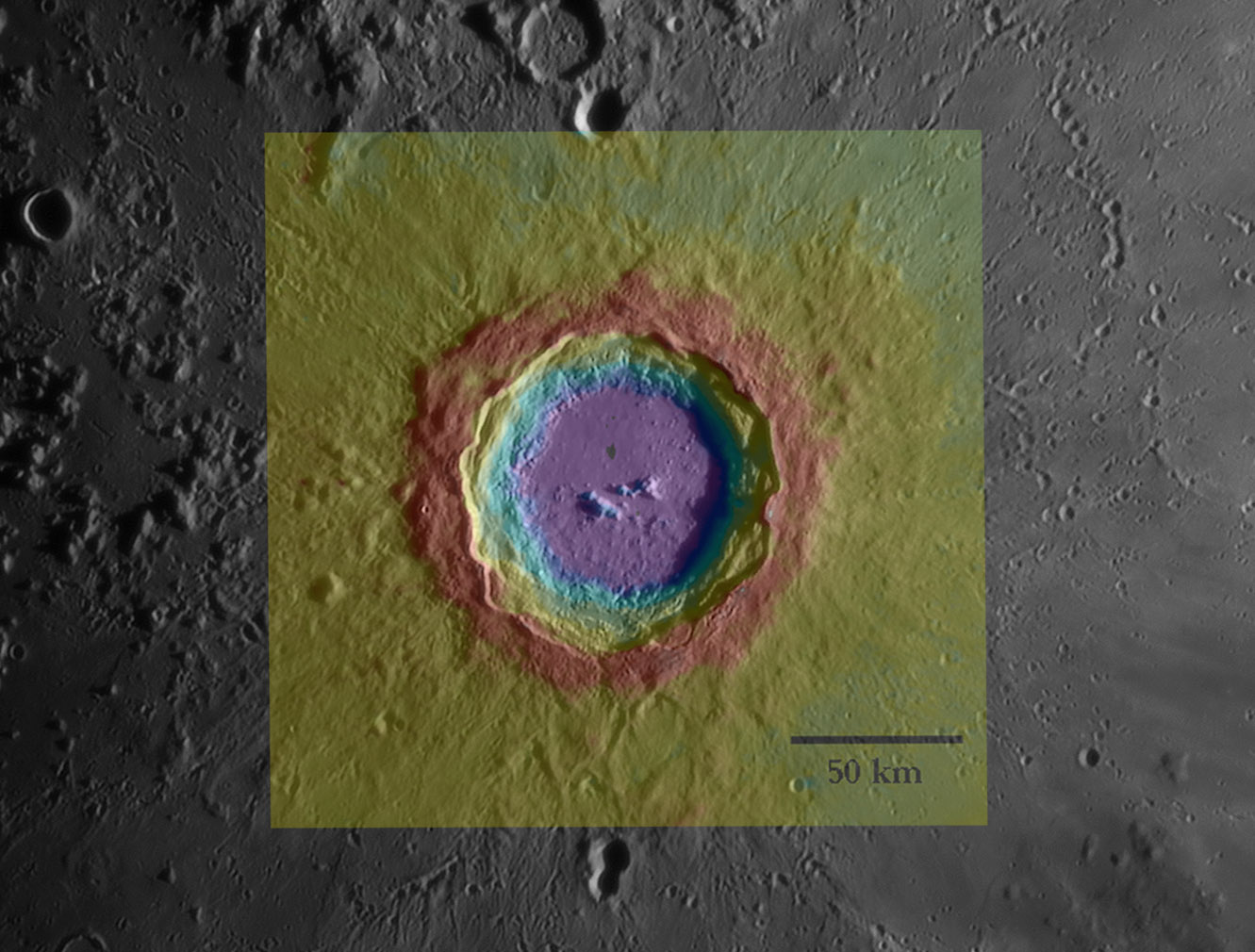
| − | <em>color image by [http://lunar.gsfc.nasa.gov/lola/ | + | <em>color image by [http://lunar.gsfc.nasa.gov/lola/ NASA, LRO LOLA] and BxW one by [mailto:slamm@blueyonder.co.uk Stefan Lammel]</em><br /> |
<br /> | <br /> | ||
Stefan's image arrived about the same time as the new topo rendition of Copernicus from the Lunar Orbiter Laser Altimeter so I combined them. I used Photoshop to enlarge and rotate the colored image to achieve an approximate fit. It looks quite good in that the boundary of the red color perfectly overlays some of the convoluted edges of the crater rim on Stefan's image. The color scale ranges from about 500 m (red) above the average lunar elevation to 2 km below it (purple). The exact values can not be read from the LOLA website chart but it appears that the crater depth is about 2.5 km. This seriously disagrees with shadow measurements that yield a rim to floor depth of 3.8 km. Why?<br /> | Stefan's image arrived about the same time as the new topo rendition of Copernicus from the Lunar Orbiter Laser Altimeter so I combined them. I used Photoshop to enlarge and rotate the colored image to achieve an approximate fit. It looks quite good in that the boundary of the red color perfectly overlays some of the convoluted edges of the crater rim on Stefan's image. The color scale ranges from about 500 m (red) above the average lunar elevation to 2 km below it (purple). The exact values can not be read from the LOLA website chart but it appears that the crater depth is about 2.5 km. This seriously disagrees with shadow measurements that yield a rim to floor depth of 3.8 km. Why?<br /> | ||
<br /> | <br /> | ||
| − | <em> | + | <em>[mailto:tychocrater@yahoo.com Chuck Wood]</em><br /> |
<br /> | <br /> | ||
<strong>Related Links</strong><br /> | <strong>Related Links</strong><br /> | ||
| − | Rükl plate | + | Rükl plate [https://the-moon.us/wiki/R%C3%BCkl_31 31]<br /> |
| − | Stefan's original [http://www.pbase.com/slammel/image/124026038/original <br /> | + | Stefan's original [http://www.pbase.com/slammel/image/124026038/original image]<br /> |
<br /> | <br /> | ||
| + | <p><b>Yesterday's LPOD:</b> [[May 1, 2010|May Day Dome]] </p> | ||
| + | <p><b>Tomorrow's LPOD:</b> [[May 3, 2010|Wilkins And the Bridge]] </p> | ||
<hr /> | <hr /> | ||
| − | < | + | <table class="wiki_table"> |
| − | </ | + | <tr> |
| − | + | <td> <!-- RemoveRevolverMaps --> | |
| − | ---- | + | <!-- RemoveRevolverMaps --> |
| − | + | </td> | |
| − | + | <!-- End of content --> | |
| + | {{wiki/ArticleFooter}} | ||
Latest revision as of 18:53, 13 October 2018
Concatenation

color image by NASA, LRO LOLA and BxW one by Stefan Lammel
Stefan's image arrived about the same time as the new topo rendition of Copernicus from the Lunar Orbiter Laser Altimeter so I combined them. I used Photoshop to enlarge and rotate the colored image to achieve an approximate fit. It looks quite good in that the boundary of the red color perfectly overlays some of the convoluted edges of the crater rim on Stefan's image. The color scale ranges from about 500 m (red) above the average lunar elevation to 2 km below it (purple). The exact values can not be read from the LOLA website chart but it appears that the crater depth is about 2.5 km. This seriously disagrees with shadow measurements that yield a rim to floor depth of 3.8 km. Why?
Chuck Wood
Related Links
Rükl plate 31
Stefan's original image
Yesterday's LPOD: May Day Dome
Tomorrow's LPOD: Wilkins And the Bridge
COMMENTS?
Register, Log in, and join in the comments.


