Difference between revisions of "May 13, 2014"
| (3 intermediate revisions by the same user not shown) | |||
| Line 1: | Line 1: | ||
__NOTOC__ | __NOTOC__ | ||
=A Bump in the Night= | =A Bump in the Night= | ||
| + | <!-- Start of content --> | ||
<!-- ws:start:WikiTextHeadingRule:0:<h1> --> | <!-- ws:start:WikiTextHeadingRule:0:<h1> --> | ||
<!-- ws:start:WikiTextLocalImageRule:6:<img src="/file/view/LPOD-May13-14.jpg/508457876/LPOD-May13-14.jpg" alt="" title="" /> -->[[File:LPOD-May13-14.jpg|LPOD-May13-14.jpg]]<!-- ws:end:WikiTextLocalImageRule:6 --><br /> | <!-- ws:start:WikiTextLocalImageRule:6:<img src="/file/view/LPOD-May13-14.jpg/508457876/LPOD-May13-14.jpg" alt="" title="" /> -->[[File:LPOD-May13-14.jpg|LPOD-May13-14.jpg]]<!-- ws:end:WikiTextLocalImageRule:6 --><br /> | ||
<em>image by [mailto:gibbidomine@libero.it Raf Lena], Roma, Italia</em><br /> | <em>image by [mailto:gibbidomine@libero.it Raf Lena], Roma, Italia</em><br /> | ||
<br /> | <br /> | ||
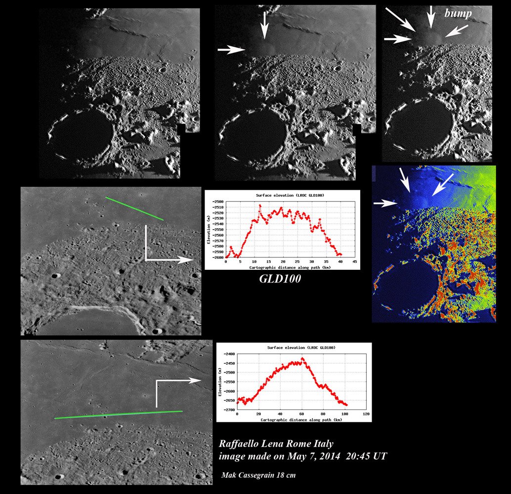
| − | As a [http://www.amazon.com/Lunar-Domes-Properties-Formation-Processes/dp/8847026369 dome master], Raf likes to prowl mare terminators, looking for little bumps in the night sky. Here is another one just north of Plato where the sharp boundary between Imbrium Basin ejecta and Mare Frigoris lavas looks like a Photoshop cut and paste to illustrate the difference between rubbly and smooth material. But this is a natural sharp edge due to lavas rising up and covering dipping ejecta. Raf's low Sun image clearly reveals an elevation that the QuickMap altimetry tool documents as being about 35 to 70 km long and 70 to 200 m high - the two profiles give different values. Because of the nearby hills and light-hued cratered area (seen on the LRO images at bottom right) this rise could be a kipuka - older terrain not completely covered by later Frigoris lava. But earlier LPODs of this [http://lpod. | + | As a [http://www.amazon.com/Lunar-Domes-Properties-Formation-Processes/dp/8847026369 dome master], Raf likes to prowl mare terminators, looking for little bumps in the night sky. Here is another one just north of Plato where the sharp boundary between Imbrium Basin ejecta and Mare Frigoris lavas looks like a Photoshop cut and paste to illustrate the difference between rubbly and smooth material. But this is a natural sharp edge due to lavas rising up and covering dipping ejecta. Raf's low Sun image clearly reveals an elevation that the QuickMap altimetry tool documents as being about 35 to 70 km long and 70 to 200 m high - the two profiles give different values. Because of the nearby hills and light-hued cratered area (seen on the LRO images at bottom right) this rise could be a kipuka - older terrain not completely covered by later Frigoris lava. But earlier LPODs of this [http://www2.lpod.org/wiki/January_30,_2012 area] and immediately to the [http://www2.lpod.org/wiki/December_5,_2009 west] show a number of similar bumps in Frigoris lavas. As I wrote in an earlier [http://www2.lpod.org/wiki/January_30,_2012 LPOD] of this area: <em>I imagine these low swells may have formed when magma or volcanic gases rose under a near surface lava flow and inflated it. We see such features on Hawaiian lava flows, but they are only meters across not 10 or more kilometers.</em> Recently QuickMap added additional layers including low Sun (chose the <em>big shadows</em> option) providing a [http://bit.ly/1mjwl0h view] of a number of other, lower swells in the area. For some reason Frigoris has a lot of swells but few classic domes.<br /> |
<br /> | <br /> | ||
<em>[mailto:tychocrater@yahoo.com Chuck Wood]</em><br /> | <em>[mailto:tychocrater@yahoo.com Chuck Wood]</em><br /> | ||
<br /> | <br /> | ||
<strong>Related Links</strong><br /> | <strong>Related Links</strong><br /> | ||
| − | <em>[ | + | <em>[[21st Century Atlas of the Moon|21st Century Atlas]]</em> chart 19.<br /> |
<br /> | <br /> | ||
| + | <p><b>Yesterday's LPOD:</b> [[May 12, 2014|Slip-Sliding Away]] </p> | ||
| + | <p><b>Tomorrow's LPOD:</b> [[May 14, 2014|Art in Planetary Science]] </p> | ||
<hr /> | <hr /> | ||
| + | {{wiki/ArticleFooter}} | ||
Latest revision as of 08:32, 28 October 2018
A Bump in the Night

image by Raf Lena, Roma, Italia
As a dome master, Raf likes to prowl mare terminators, looking for little bumps in the night sky. Here is another one just north of Plato where the sharp boundary between Imbrium Basin ejecta and Mare Frigoris lavas looks like a Photoshop cut and paste to illustrate the difference between rubbly and smooth material. But this is a natural sharp edge due to lavas rising up and covering dipping ejecta. Raf's low Sun image clearly reveals an elevation that the QuickMap altimetry tool documents as being about 35 to 70 km long and 70 to 200 m high - the two profiles give different values. Because of the nearby hills and light-hued cratered area (seen on the LRO images at bottom right) this rise could be a kipuka - older terrain not completely covered by later Frigoris lava. But earlier LPODs of this area and immediately to the west show a number of similar bumps in Frigoris lavas. As I wrote in an earlier LPOD of this area: I imagine these low swells may have formed when magma or volcanic gases rose under a near surface lava flow and inflated it. We see such features on Hawaiian lava flows, but they are only meters across not 10 or more kilometers. Recently QuickMap added additional layers including low Sun (chose the big shadows option) providing a view of a number of other, lower swells in the area. For some reason Frigoris has a lot of swells but few classic domes.
Chuck Wood
Related Links
21st Century Atlas chart 19.
Yesterday's LPOD: Slip-Sliding Away
Tomorrow's LPOD: Art in Planetary Science
COMMENTS?
Register, Log in, and join in the comments.


