Difference between revisions of "May 12, 2014"
| (7 intermediate revisions by the same user not shown) | |||
| Line 1: | Line 1: | ||
__NOTOC__ | __NOTOC__ | ||
=Slip-Sliding Away= | =Slip-Sliding Away= | ||
| − | + | <!-- Start of content --> | |
| − | + | <!-- ws:start:WikiTextHeadingRule:0:<h1> --> | |
| − | + | <!-- ws:start:WikiTextLocalImageRule:14:<img src="/file/view/LPOD-May12-14.jpg/508188204/LPOD-May12-14.jpg" alt="" title="" /> -->[[File:LPOD-May12-14.jpg|LPOD-May12-14.jpg]]<!-- ws:end:WikiTextLocalImageRule:14 --><br /> | |
<em>image by [mailto:jdelpeix@gmail.com Jordi Delpeix Borrell ], l'Ametlla del Vallès (Barcelona) Spain</em><br /> | <em>image by [mailto:jdelpeix@gmail.com Jordi Delpeix Borrell ], l'Ametlla del Vallès (Barcelona) Spain</em><br /> | ||
<br /> | <br /> | ||
| − | |||
<table class="wiki_table"> | <table class="wiki_table"> | ||
| − | + | <tr> | |
| − | + | <td><!-- ws:start:WikiTextLocalImageRule:15:<img src="/file/view/LPOD-May12b-14.jpg/508190776/LPOD-May12b-14.jpg" alt="" title="" /> -->[[File:LPOD-May12b-14.jpg|LPOD-May12b-14.jpg]]<!-- ws:end:WikiTextLocalImageRule:15 --><br /> | |
</td> | </td> | ||
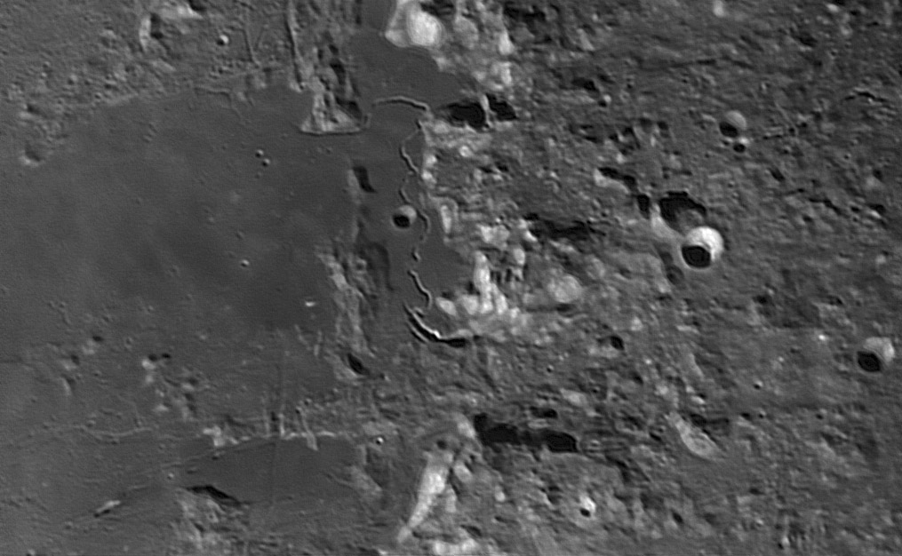
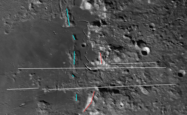
| − | + | <td>Jordi has produced an excellent image centered on the Hadley Rille. The rille itself can be traced to the north where it clings to the edge of a massif and then winds faintly across the mare towards inconsequentiality. I especially like it that the multiple vents at the south end of the rille are very well shown ([https://the-moon.us/wiki/B%C3%A9la Bela], [https://the-moon.us/wiki/Carlos Carlos], [https://the-moon.us/wiki/Jomo Jomo], and [https://the-moon.us/wiki/Taizo Taizo]). But what catches my eye even more is the break in the mountainous front of the Apennines. The red line on the small image traces the front, which is completely missing in the space between the two long white lines. A ridge (blue) of probable landslide material from the front is also mostly missing between the white lines. As I have mused [http://www.lpod.org/?p=159 before] it looks like the eastern rim of the Imbrium Basin has been sheared by many faults approximately radial to the basin center; [http://www.lpod.org/archive/LPOD-2004-12-14.htm here] is the most famous. The area between the long white lines looks like a place where the Imbrium ejecta has moved laterally. But which direction? An altimetry trace from LRO Quickmap shows that the topography drops 3 km from the right side of the area between the lines to the left. The downhill direction is towards the center of the basin, implying that that was the direction of movement. Somewhere under the covering of Imbrium lavas there may be the missing mountain front (red line) and landslide ridge (blue line). It is not surprising that the Hadley Rille vents are near the fracture lines, exactly where there could be conduits for magma to rise to the surface.<br /> | |
<br /> | <br /> | ||
<em>[mailto:tychocrater@yahoo.com Chuck Wood]</em><br /> | <em>[mailto:tychocrater@yahoo.com Chuck Wood]</em><br /> | ||
| Line 19: | Line 18: | ||
<br /> | <br /> | ||
<strong>Related Links</strong><br /> | <strong>Related Links</strong><br /> | ||
| − | <em>[ | + | <em>[[21st Century Atlas of the Moon|21st Century Atlas]]</em> chart 11.<br /> |
</td> | </td> | ||
| − | + | </tr> | |
</table> | </table> | ||
| − | |||
<br /> | <br /> | ||
| + | <p><b>Yesterday's LPOD:</b> [[May 11, 2014|Globe History]] </p> | ||
| + | <p><b>Tomorrow's LPOD:</b> [[May 13, 2014|A Bump in the Night]] </p> | ||
<hr /> | <hr /> | ||
| − | + | {{wiki/ArticleFooter}} | |
| − | |||
| − | |||
| − | |||
| − | |||
Latest revision as of 08:32, 28 October 2018
Slip-Sliding Away

image by Jordi Delpeix Borrell , l'Ametlla del Vallès (Barcelona) Spain
 |
Jordi has produced an excellent image centered on the Hadley Rille. The rille itself can be traced to the north where it clings to the edge of a massif and then winds faintly across the mare towards inconsequentiality. I especially like it that the multiple vents at the south end of the rille are very well shown (Bela, Carlos, Jomo, and Taizo). But what catches my eye even more is the break in the mountainous front of the Apennines. The red line on the small image traces the front, which is completely missing in the space between the two long white lines. A ridge (blue) of probable landslide material from the front is also mostly missing between the white lines. As I have mused before it looks like the eastern rim of the Imbrium Basin has been sheared by many faults approximately radial to the basin center; here is the most famous. The area between the long white lines looks like a place where the Imbrium ejecta has moved laterally. But which direction? An altimetry trace from LRO Quickmap shows that the topography drops 3 km from the right side of the area between the lines to the left. The downhill direction is towards the center of the basin, implying that that was the direction of movement. Somewhere under the covering of Imbrium lavas there may be the missing mountain front (red line) and landslide ridge (blue line). It is not surprising that the Hadley Rille vents are near the fracture lines, exactly where there could be conduits for magma to rise to the surface.
|
Yesterday's LPOD: Globe History
Tomorrow's LPOD: A Bump in the Night
COMMENTS?
Register, Log in, and join in the comments.


