Difference between revisions of "May 10, 2012"
(Created page with "__NOTOC__ =Massive Map of Little Impact= <!-- ws:start:WikiTextHeadingRule:1:<h1> --> <!-- ws:start:WikiTextLocalImageRule:15:<img src="/file/view/LPOD-Dec1-...") |
|||
| Line 36: | Line 36: | ||
<hr /> | <hr /> | ||
| + | <table class="wiki_table"> | ||
| + | <tr> | ||
| + | <td><!-- ws:start:WikiTextMediaRule:0:<img src="http://www.wikispaces.com/site/embedthumbnail/custom/4929871?h=0&w=0" class="WikiMedia WikiMediaCustom" id="wikitext@@media@@type=&quot;custom&quot; key=&quot;4929871&quot;" title="Custom Media"/> --><!-- ws:end:WikiTextMediaRule:0 --><br /> | ||
| + | </td> | ||
Revision as of 22:02, 1 January 2015
Massive Map of Little Impact
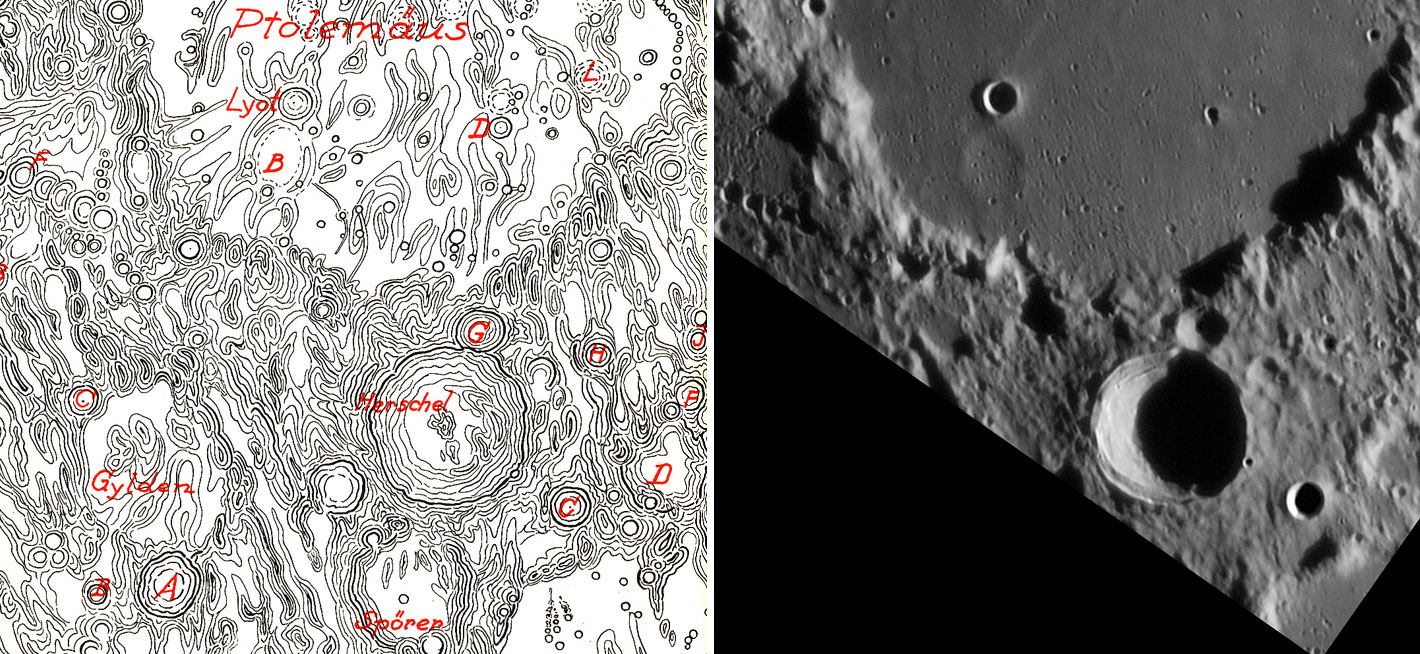
map from Fauth's Mond Atlas, and image by Wes Higgins
Note: This is a reprint of the LPOD from Dec 1, 2009.
One of the hardest working and least appreciated lunar mappers was Phillip Fauth (1867-1941). In his early days he
inaugurated what he called a modern selenology, which focused on measurements and analysis of crater diameters,
depths and slopes. He started a quantitative approach to lunar morphology studies which - after about 60 years of
inattention - finally caught on in the post-Apollo period. There are three reasons that Fauth was ignored. First, as shown
in his 1907 book The Moon in Modern Astronomy, he was boastful and nationalistic. Second, he became intimately
associated with the crank, Hörbiger, who believed that the Moon and other worlds were covered in ice. But this full
size copy of a small piece of his monumental 25 sheet map shows a more powerful reason for neglect: his cartography
was just too hard to interpret. Granted, no map looks good next to an image by Wes Higgins, but the pseudo contours
are confusing, with ups and downs being uncertain away from craters. I feel that shading needs to be added to give a
three-dimension feeling to the contours. This map is like WIlkin's 300" map of roughly the same vintage. Both concentrate
on details so much that legibility and interpretability become difficult. Fauth's large map was not completed when he
died and his son finished it and brought it out in a nice edition in 1964. Fauth had always railed against photography,
believing that a good trained eye could see more. But by 1964 the famous Mt WIlson photographs and then spacecraft
images demonstrated that visual map makers would never catch up with photos, and his map was only of historic interest.
Chuck Wood
Note: I've enjoyed researching Fauth's life online and rereading the Fauth chapter in the utterly wonderful Epic Moon by
Sheehan and Dobbins!
Technical Details
Wes' image details are here.
Related Links
Rükl plate 44
Review of 1907 book.
Obituary (in French)
COMMENTS?
Click on this icon File:PostIcon.jpg at the upper right to post a comment.


