Difference between revisions of "March 5, 2014"
| Line 1: | Line 1: | ||
__NOTOC__ | __NOTOC__ | ||
=A Little Scar= | =A Little Scar= | ||
| − | |||
<!-- ws:start:WikiTextHeadingRule:0:<h1> --> | <!-- ws:start:WikiTextHeadingRule:0:<h1> --> | ||
<!-- ws:start:WikiTextLocalImageRule:6:<img src="/file/view/LPOD-Mar5-14.jpg/493640052/LPOD-Mar5-14.jpg" alt="" title="" /> -->[[File:LPOD-Mar5-14.jpg|LPOD-Mar5-14.jpg]]<!-- ws:end:WikiTextLocalImageRule:6 --><br /> | <!-- ws:start:WikiTextLocalImageRule:6:<img src="/file/view/LPOD-Mar5-14.jpg/493640052/LPOD-Mar5-14.jpg" alt="" title="" /> -->[[File:LPOD-Mar5-14.jpg|LPOD-Mar5-14.jpg]]<!-- ws:end:WikiTextLocalImageRule:6 --><br /> | ||
| − | <em>image by [mailto:jdelpeix@gmail.com Jordi Delpeix Borrell], l'Ametlla del Vallès (Barcelona) Spain</em><br /> | + | <em>image by [mailto:jdelpeix@gmail.com" rel="nofollow Jordi Delpeix Borrell], l'Ametlla del Vallès (Barcelona) Spain</em><br /> |
<br /> | <br /> | ||
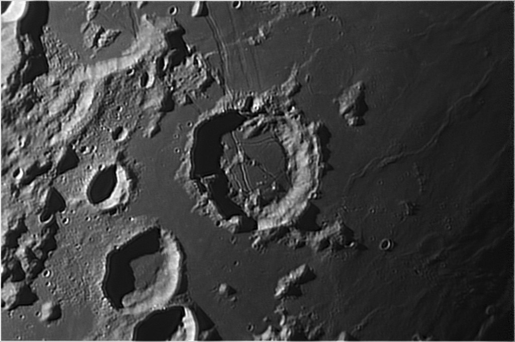
| − | A new contributor to LPOD appears with an excellent image of [http://the-moon.wikispaces.com/Goclenius Goclenius]. The lighting suggests that its floor rises towards the rille that hugs the upper right crater wall, but the LRO [http://bit.ly/1eU7Una QuickMap] topographic tool shows exactly the opposite. The pie-shaped part of the floor is about level, but once the upper diagonal rille is crossed the land slopes about 140 m to the east/right, and at the wall rille, it plunges down another 250 m. Our eyes, or at least mine, are often fooled by lighting, and need measured topography to really understand what is going on; fortunately, we now have it. The mare surface east of Goclenius undulates with mare ridges, buried crater rims, and slight swells tens of meter high. One more odd thing - look at the center of [http://the-moon.wikispaces.com/Magelhaens Magelhaens], at lower left. Small, slightly bright points looks like a smallpox vaccine scar. LRO's higher resolution shows the same thing. Because it is in the center of the crater it could be the just slightly lava-covered tops of a cluster of central peaks, but it isn't completely convincing that that is what it is.<br /> | + | A new contributor to LPOD appears with an excellent image of [http://the-moon.wikispaces.com/Goclenius Goclenius]. The lighting suggests that its floor rises towards the rille that hugs the upper right crater wall, but the LRO [http://bit.ly/1eU7Una" rel="nofollow QuickMap] topographic tool shows exactly the opposite. The pie-shaped part of the floor is about level, but once the upper diagonal rille is crossed the land slopes about 140 m to the east/right, and at the wall rille, it plunges down another 250 m. Our eyes, or at least mine, are often fooled by lighting, and need measured topography to really understand what is going on; fortunately, we now have it. The mare surface east of Goclenius undulates with mare ridges, buried crater rims, and slight swells tens of meter high. One more odd thing - look at the center of [http://the-moon.wikispaces.com/Magelhaens Magelhaens], at lower left. Small, slightly bright points looks like a smallpox vaccine scar. LRO's higher resolution shows the same thing. Because it is in the center of the crater it could be the just slightly lava-covered tops of a cluster of central peaks, but it isn't completely convincing that that is what it is.<br /> |
<br /> | <br /> | ||
| − | <em>[mailto:tychocrater@yahoo.com Chuck Wood]</em><br /> | + | <em>[mailto:tychocrater@yahoo.com" rel="nofollow Chuck Wood]</em><br /> |
<br /> | <br /> | ||
<strong>Technical Details</strong><br /> | <strong>Technical Details</strong><br /> | ||
Revision as of 22:56, 4 January 2015
A Little Scar

image by " rel="nofollow Jordi Delpeix Borrell, l'Ametlla del Vallès (Barcelona) Spain
A new contributor to LPOD appears with an excellent image of Goclenius. The lighting suggests that its floor rises towards the rille that hugs the upper right crater wall, but the LRO " rel="nofollow QuickMap topographic tool shows exactly the opposite. The pie-shaped part of the floor is about level, but once the upper diagonal rille is crossed the land slopes about 140 m to the east/right, and at the wall rille, it plunges down another 250 m. Our eyes, or at least mine, are often fooled by lighting, and need measured topography to really understand what is going on; fortunately, we now have it. The mare surface east of Goclenius undulates with mare ridges, buried crater rims, and slight swells tens of meter high. One more odd thing - look at the center of Magelhaens, at lower left. Small, slightly bright points looks like a smallpox vaccine scar. LRO's higher resolution shows the same thing. Because it is in the center of the crater it could be the just slightly lava-covered tops of a cluster of central peaks, but it isn't completely convincing that that is what it is.
" rel="nofollow Chuck Wood
Technical Details
September/23/2013. C9,25" + Barlow 2X + DSLR Canon EOS 550D. Processed with Registax6.
Related Links
21st Century Atlas chart 3.


