Difference between revisions of "March 23, 2014"
(Created page with "__NOTOC__ =Three Mysteries for the Price of Two= <!-- ws:start:WikiTextHeadingRule:0:<h1> --> <!-- ws:start:WikiTextLocalImageRule:6:<img src="/file/view/LPO...") |
|||
| Line 2: | Line 2: | ||
=Three Mysteries for the Price of Two= | =Three Mysteries for the Price of Two= | ||
| − | + | <!-- ws:start:WikiTextHeadingRule:0:<h1> --> | |
| − | + | <!-- ws:start:WikiTextLocalImageRule:6:<img src="/file/view/LPOD-Mar23-14.jpg/497642422/LPOD-Mar23-14.jpg" alt="" title="" /> -->[[File:LPOD-Mar23-14.jpg|LPOD-Mar23-14.jpg]]<!-- ws:end:WikiTextLocalImageRule:6 --><br /> | |
<em>left image by [mailto:alejandrosanz617@gmail.com Alejandro Sanz], Burgos, Spain and right image from LRO Quickmap (NASA/ASU)</em><br /> | <em>left image by [mailto:alejandrosanz617@gmail.com Alejandro Sanz], Burgos, Spain and right image from LRO Quickmap (NASA/ASU)</em><br /> | ||
<br /> | <br /> | ||
| Line 20: | Line 20: | ||
<br /> | <br /> | ||
<hr /> | <hr /> | ||
| − | |||
| − | |||
| − | |||
| − | |||
Revision as of 00:59, 3 January 2015
Three Mysteries for the Price of Two

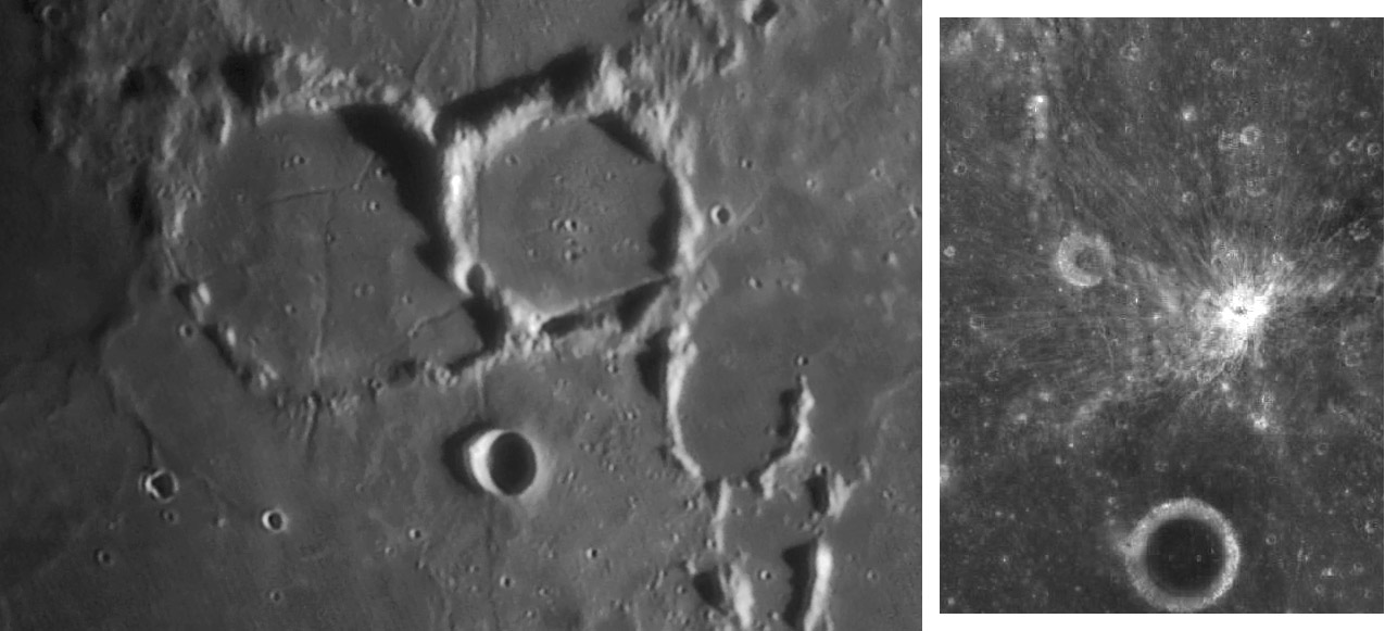
left image by Alejandro Sanz, Burgos, Spain and right image from LRO Quickmap (NASA/ASU)
Two things in a larger mosaic by Alex caught my attention and I clipped out just the piece that shows them. Do you notice them?
Notice on the floor of Parry (center, right) the semi-circular edge separating raised and heavily cratered terrain to the east from lower and smoother terrain to the west. The LRO QuickMap doesn't reveal such a sharp boundary, but the topo data show that the cratered part is 70-80 m higher than the smooth part. This could be a kipuka - a high remnant - of older rocks, but why isn't it covered by the smooth basin ejecta on the west side of the crater floor? The second anomaly I noticed is just to the west of Tolansky, the shadow-filled, 13 km wide simple crater at bottom-center. Do you see the two or three elongated slightly bright, flow-like features? These look like lava flows. But Quickmap shows no hint of them at all. Are they an artifact of processing and my enhancements? Finally, a third feature jumped out when I looked at the Quickmap of this area. Do you see the 2 km wide bright craterlet on the south rim of Parry? Quickmap (right image) reveals a fine tracery of rays extending to the north and west. The lack of rays in other directions suggests that this could be a crater formed by oblique impact. But the craterlet is on the inner slope of Parry's rim, and the north rim of the craterlet is about 700 m lower than the south rim. It may be that the slope directed ejecta to the north and west, even if the impact were vertical.
Chuck Wood
PS- If you click on QuickMap to increase magnification, when the NAC images appear some are flipped east to west. Check out Parry E and other strips to the west. I have never seen this error before on QuickMap.
Technical Details
March10, 2014, 19:13 U.T. C11 + 3x powermate + DMK31 + red filter
Related Links
21st Century Atlas chart 17.
Alex's website


