|
|
| Line 2: |
Line 2: |
| | =Notice the Pineapple?= | | =Notice the Pineapple?= |
| | | | |
| − | <!-- ws:start:WikiTextHeadingRule:0:<h1> -->
| + | <!-- ws:start:WikiTextHeadingRule:0:<h1> --> |
| − | <!-- ws:start:WikiTextLocalImageRule:14:<img src="/file/view/LPOD-Mar2-14.jpg/492930100/LPOD-Mar2-14.jpg" alt="" title="" /> -->[[File:LPOD-Mar2-14.jpg|LPOD-Mar2-14.jpg]]<!-- ws:end:WikiTextLocalImageRule:14 --><br />
| + | <!-- ws:start:WikiTextLocalImageRule:14:<img src="/file/view/LPOD-Mar2-14.jpg/492930100/LPOD-Mar2-14.jpg" alt="" title="" /> -->[[File:LPOD-Mar2-14.jpg|LPOD-Mar2-14.jpg]]<!-- ws:end:WikiTextLocalImageRule:14 --><br /> |
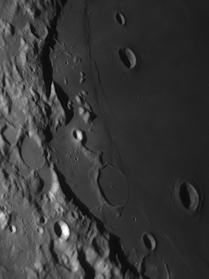
| | <em>image by [mailto:aerts.leo@skynet.be Leo Aerts], Belgium</em><br /> | | <em>image by [mailto:aerts.leo@skynet.be Leo Aerts], Belgium</em><br /> |
| − |
| |
| − | <table class="wiki_table">
| |
| − | <tr>
| |
| − | <td><!-- ws:start:WikiTextLocalImageRule:15:<img src="/file/view/LPOD-Mar2b-14.jpg/492930134/LPOD-Mar2b-14.jpg" alt="" title="" /> -->[[File:LPOD-Mar2b-14.jpg|LPOD-Mar2b-14.jpg]]<!-- ws:end:WikiTextLocalImageRule:15 --><br />
| |
| − | </td>
| |
| − | <td>Basin rims intrigue me. I want to understand why they usually are not tall and continuous as fresh crater rims are. Here, the question is why is the western rim of the Crisium Basin broken? North and south of here most of Crisium's rim is continuous. Here in the west it looks like a vehicle could be driven from the outside to the inside on level ground where the two sloping promontories almost touch. (With LRO [http://bit.ly/1klSlYL QuickMap] you can see that there is one ridge to drive over.) The two large, ruined craters with flat floors postdate the formation of the basin (they would have been destroyed if they were first) and they do cut into the western rim. But with a basin-wide [http://bit.ly/NHIaQk perspective] we are reminded that the eastern side of the basin is even more open, some of the evidence that Crisium formed from an oblique impact. So, perhaps there were two processes at work here. An oblique impact with the projectile coming from the west formed a basin with low east and west rims, and two later impacts carved away a gap through the already low western rim segment. On another topic, notice the slightly elevated and fractured terrain just west of the rim, and northwest of Yerkes. This looks like the interior of a floor fractured crater, minus the crater. Similar fracturing is inside Lick. Are the few low hills nearby remnants of a rim, or is this a case of floor-fracturing not inside a crater?<br />
| |
| − | <br />
| |
| − | <em>[mailto:tychocrater@yahoo.com Chuck Wood]</em><br />
| |
| − | <br />
| |
| − | <strong>Technical Details</strong><br />
| |
| − | Celestron 14, 1.8x barlow projection, dispersion corrector used and webcam DMK31AF03.<br />
| |
| − | <br />
| |
| − | <strong>Related Links</strong><br />
| |
| − | <em>[http://lpod.wikispaces.com/21st+Century+Atlas+of+the+Moon 21st Century Atlas]</em> chart 2.<br />
| |
| | <br /> | | <br /> |
| | <hr /> | | <hr /> |
| − | | + | You can support LPOD when you buy any book from Amazon thru [http://www.lpod.org/?page_id=591 LPOD!] |
| | + | </div> |
| | | | |
| | ---- | | ---- |
| | ===COMMENTS?=== | | ===COMMENTS?=== |
| | Click on this icon [[image:PostIcon.jpg]] at the upper right to post a comment. | | Click on this icon [[image:PostIcon.jpg]] at the upper right to post a comment. |


