Difference between revisions of "June 24, 2004"
(Created page with "__NOTOC__ =Gambart Environs= ---- ===COMMENTS?=== Click on this icon image:PostIcon.jpg at the upper right to post a comment.") |
|||
| (14 intermediate revisions by the same user not shown) | |||
| Line 1: | Line 1: | ||
__NOTOC__ | __NOTOC__ | ||
=Gambart Environs= | =Gambart Environs= | ||
| − | + | <!-- Start of content --> | |
| − | + | <table width="640" border="0" align="center" cellpadding="6" cellspacing="2"> | |
| − | + | <tr> | |
| − | ---- | + | </tr> |
| − | === | + | </table> |
| − | + | <table width="85%" border="0" align="center" cellpadding="6" cellspacing="2"> | |
| + | <tr> | ||
| + | <td colspan="2"><div align="center"> | ||
| + | {{HoverImage|LPOD-2004-06-24.jpeg|LPOD-2004-06-24b.jpeg}} | ||
| + | </div></td> | ||
| + | </tr> | ||
| + | </table> | ||
| + | <table width="100%" border="0" cellpadding="8"> | ||
| + | <tr> | ||
| + | <td><div align="center"><p>Image Credit: [mailto:thefamily90@hotmail.com Jim Phillips ]</p></div></td> | ||
| + | </tr> | ||
| + | </table> | ||
| + | <table class="story" border="0" bgcolor="#FFFFFF" width="90%" cellpadding="10" align="center"><tr><td> | ||
| + | <p class="story" align="center"><b>Gambart Environs</b></p> | ||
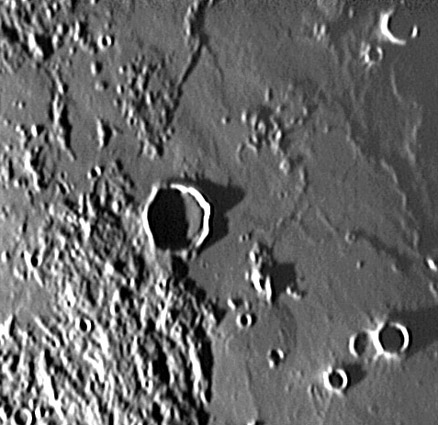
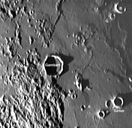
| + | <p class="story" align="left">South of Copernicus is the flat floored, 25 km wide crater Gambart. This is a member of a class of relatively fresh looking craters with smooth rims and rough polygonal outlines. Some researchers have argued that Gambart-like craters are volcanic calderas, while other scientists interpret them as secondary craters from the formation of impact basins. But for this image, Gambart is more important as a guidepost to interesting but subtle topography. South and west of Gambart is a hilly, almost corrugated low terrain that was explored further south near Fra Mauro by Apollo 14. This material is crushed rock excavated when Imbrium was formed 3.84 b.y. ago - it is basin ejecta. Such ejecta must extend all around Imbrium but in many places where the elevation is low it has been buried by more recent mare lavas. Just north of Gambart is a low swelling about 14 km wide made when this lava was emplaced. But much more interesting is the 29 km swelling between Gambart M and Turner A (mouseover for designations). This low feature is similar to the [[February_14,_2004|Valentine Dome]] in northwestern Serenitatis. Its nearly the same size, is similarly flat, and is also cut by a small rille just visible on its west flank. Great image, Jim!</p> | ||
| + | <p class="story" align="left"><b>Technical Details:</b><br> | ||
| + | June 11, 2004; TMB 8" F/9 apo, webcam, registax. 3X barlow. CAW used an unsharp mask to enhance the image. Note that dark band around the east edge of Gambart's floor is a processing artifact, not a shadow. | ||
| + | </p> | ||
| + | <p class="story"><b>Related Links:</b><br> | ||
| + | [http://observingthesky.org/index.php?p=188 Jim Phillips & Scope]<br> | ||
| + | [http://www.lpi.usra.edu/research/lunar_orbiter/images/aimg/iv_121_h1.jpg Lunar Orbiter IV View] | ||
| + | </p> | ||
| + | <p><b>Yesterday's LPOD:</b> [[June 23, 2004|Concentric Craters]] </p> | ||
| + | <p><b>Tomorrow's LPOD:</b> [[June 25, 2004|Cassini Observed]] </p> | ||
| + | </table> | ||
| + | <!-- start bottom --> | ||
| + | <table width="100%" border="0" cellspacing="2" cellpadding="4"> | ||
| + | <tr> | ||
| + | <td><hr></td> | ||
| + | </tr> | ||
| + | <tr> | ||
| + | <td><p align="center" class="main_titles"><b>Author & Editor:</b><br> | ||
| + | [mailto:tychocrater@yahoo.com Charles A. Wood]</p> | ||
| + | <!-- Cleanup of credits --> | ||
| + | <!-- Cleanup of credits --> | ||
| + | <!-- Cleanup of credits --> | ||
| + | <!-- Cleanup of credits --> | ||
| + | <!-- Cleanup of credits --> | ||
| + | <!-- Cleanup of credits --> | ||
| + | <!-- Cleanup of credits --> | ||
| + | </tr> | ||
| + | </table> | ||
| + | <!-- end cal --> | ||
| + | <div align="center"></div> | ||
| + | <p> </p> | ||
| + | <!-- End of content --> | ||
| + | {{wiki/ArticleFooter}} | ||
Latest revision as of 22:39, 8 February 2015
Gambart Environs
Image Credit: Jim Phillips |
|
Gambart Environs South of Copernicus is the flat floored, 25 km wide crater Gambart. This is a member of a class of relatively fresh looking craters with smooth rims and rough polygonal outlines. Some researchers have argued that Gambart-like craters are volcanic calderas, while other scientists interpret them as secondary craters from the formation of impact basins. But for this image, Gambart is more important as a guidepost to interesting but subtle topography. South and west of Gambart is a hilly, almost corrugated low terrain that was explored further south near Fra Mauro by Apollo 14. This material is crushed rock excavated when Imbrium was formed 3.84 b.y. ago - it is basin ejecta. Such ejecta must extend all around Imbrium but in many places where the elevation is low it has been buried by more recent mare lavas. Just north of Gambart is a low swelling about 14 km wide made when this lava was emplaced. But much more interesting is the 29 km swelling between Gambart M and Turner A (mouseover for designations). This low feature is similar to the Valentine Dome in northwestern Serenitatis. Its nearly the same size, is similarly flat, and is also cut by a small rille just visible on its west flank. Great image, Jim! Technical Details: Related Links: Yesterday's LPOD: Concentric Craters Tomorrow's LPOD: Cassini Observed |
Author & Editor: |
COMMENTS?
Register, Log in, and join in the comments.


