Difference between revisions of "June 20, 2012"
| Line 1: | Line 1: | ||
__NOTOC__ | __NOTOC__ | ||
=A Little Volcanic Center= | =A Little Volcanic Center= | ||
| − | |||
<!-- ws:start:WikiTextHeadingRule:0:<h1> --> | <!-- ws:start:WikiTextHeadingRule:0:<h1> --> | ||
<!-- ws:start:WikiTextLocalImageRule:14:<img src="/file/view/LPOD-Jun20-12.jpg/346577924/LPOD-Jun20-12.jpg" alt="" title="" /> -->[[File:LPOD-Jun20-12.jpg|LPOD-Jun20-12.jpg]]<!-- ws:end:WikiTextLocalImageRule:14 --><br /> | <!-- ws:start:WikiTextLocalImageRule:14:<img src="/file/view/LPOD-Jun20-12.jpg/346577924/LPOD-Jun20-12.jpg" alt="" title="" /> -->[[File:LPOD-Jun20-12.jpg|LPOD-Jun20-12.jpg]]<!-- ws:end:WikiTextLocalImageRule:14 --><br /> | ||
| − | <em>LRO oblique NAC image processed by [mailto:mauricejscollins@hotmail.com Maurice Collins], New Zealand</em><br /> | + | <em>LRO oblique NAC image processed by [mailto:mauricejscollins@hotmail.com" rel="nofollow Maurice Collins], New Zealand</em><br /> |
<table class="wiki_table"> | <table class="wiki_table"> | ||
<tr> | <tr> | ||
<td><!-- ws:start:WikiTextLocalImageRule:15:<img src="/file/view/LPOD-Jun20b-12.jpg/346582708/LPOD-Jun20b-12.jpg" alt="" title="" /> -->[[File:LPOD-Jun20b-12.jpg|LPOD-Jun20b-12.jpg]]<!-- ws:end:WikiTextLocalImageRule:15 --><br /> | <td><!-- ws:start:WikiTextLocalImageRule:15:<img src="/file/view/LPOD-Jun20b-12.jpg/346582708/LPOD-Jun20b-12.jpg" alt="" title="" /> -->[[File:LPOD-Jun20b-12.jpg|LPOD-Jun20b-12.jpg]]<!-- ws:end:WikiTextLocalImageRule:15 --><br /> | ||
</td> | </td> | ||
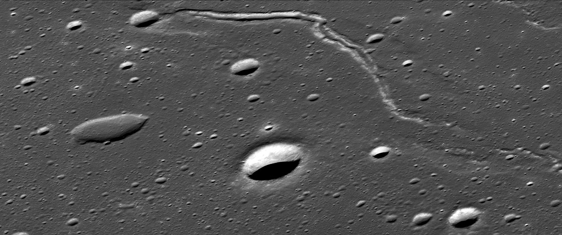
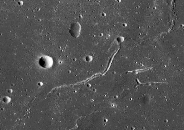
| − | <td>I wonder if anyone other than Danny Caes immediately recognizes this image. It is a different view of a classic Apollo 15 [http://www.astrosurf.com/lunascan/AS15-9309.htm photo] of a lava channel in eastern Mare Serenitatis. The bright, unlettered impact crater near the center is 3.2 km wide and the rille is about 600 m wide where its bright levee is visible, and its about 19 km long going all the way to where it becomes a short mare ridge. I say <em>about</em> because the QuickMap does not seem to give consistent and reasonable height measurements for this feature. It is not clear if the degraded crater at the start of the rille is a volcanic vent or simply an older impact crater - I lean toward the latter interpretation. The beginnng of the rille cuts into a hill about 6 km wide and 100 m high - a miniature version of the Cobra Head mountain. As the lava flowed across the pre-existing surface its edges cooled, creating the well-seen levees. Dale Cruikshank and I watched the same thing happen - a lava flow becoming a lava channel - in Hawaai about 40 years ago. As the lunar channel narrowed, finally the two levees came together, looking like a mare ridge; perhaps a narrow lava tube continues underground. The broad, shallow and rimless crater to the west is either a volcanic collapse or an old impact crater who's floor has been filled by lava flows. The lack of a rim and the non-circular shape suggest that it is a volcanic collapse. In fact, that interpretation is strengthened when pulling back to look at a larger area with the LRO QuickMap image to the left. This shows two additional linear vents and another lava collapse. These five features suggest that this is a 25 km wide feature that I am calling the East Serenitatis Volcanic Field. It is centered at about 28.3°N, 28.1°E. Another short sinuous rille is 50 km to the west, but no other volcanic vent is immediately nearby.<br /> | + | <td>I wonder if anyone other than Danny Caes immediately recognizes this image. It is a different view of a classic Apollo 15 [http://www.astrosurf.com/lunascan/AS15-9309.htm" rel="nofollow photo] of a lava channel in eastern Mare Serenitatis. The bright, unlettered impact crater near the center is 3.2 km wide and the rille is about 600 m wide where its bright levee is visible, and its about 19 km long going all the way to where it becomes a short mare ridge. I say <em>about</em> because the QuickMap does not seem to give consistent and reasonable height measurements for this feature. It is not clear if the degraded crater at the start of the rille is a volcanic vent or simply an older impact crater - I lean toward the latter interpretation. The beginnng of the rille cuts into a hill about 6 km wide and 100 m high - a miniature version of the Cobra Head mountain. As the lava flowed across the pre-existing surface its edges cooled, creating the well-seen levees. Dale Cruikshank and I watched the same thing happen - a lava flow becoming a lava channel - in Hawaai about 40 years ago. As the lunar channel narrowed, finally the two levees came together, looking like a mare ridge; perhaps a narrow lava tube continues underground. The broad, shallow and rimless crater to the west is either a volcanic collapse or an old impact crater who's floor has been filled by lava flows. The lack of a rim and the non-circular shape suggest that it is a volcanic collapse. In fact, that interpretation is strengthened when pulling back to look at a larger area with the LRO QuickMap image to the left. This shows two additional linear vents and another lava collapse. These five features suggest that this is a 25 km wide feature that I am calling the East Serenitatis Volcanic Field. It is centered at about 28.3°N, 28.1°E. Another short sinuous rille is 50 km to the west, but no other volcanic vent is immediately nearby.<br /> |
<br /> | <br /> | ||
| − | <em>[mailto:tychocrater@yahoo.com Chuck Wood]</em><br /> | + | <em>[mailto:tychocrater@yahoo.com" rel="nofollow Chuck Wood]</em><br /> |
</td> | </td> | ||
</tr> | </tr> | ||
Revision as of 22:32, 4 January 2015
A Little Volcanic Center

LRO oblique NAC image processed by " rel="nofollow Maurice Collins, New Zealand
 |
I wonder if anyone other than Danny Caes immediately recognizes this image. It is a different view of a classic Apollo 15 " rel="nofollow photo of a lava channel in eastern Mare Serenitatis. The bright, unlettered impact crater near the center is 3.2 km wide and the rille is about 600 m wide where its bright levee is visible, and its about 19 km long going all the way to where it becomes a short mare ridge. I say about because the QuickMap does not seem to give consistent and reasonable height measurements for this feature. It is not clear if the degraded crater at the start of the rille is a volcanic vent or simply an older impact crater - I lean toward the latter interpretation. The beginnng of the rille cuts into a hill about 6 km wide and 100 m high - a miniature version of the Cobra Head mountain. As the lava flowed across the pre-existing surface its edges cooled, creating the well-seen levees. Dale Cruikshank and I watched the same thing happen - a lava flow becoming a lava channel - in Hawaai about 40 years ago. As the lunar channel narrowed, finally the two levees came together, looking like a mare ridge; perhaps a narrow lava tube continues underground. The broad, shallow and rimless crater to the west is either a volcanic collapse or an old impact crater who's floor has been filled by lava flows. The lack of a rim and the non-circular shape suggest that it is a volcanic collapse. In fact, that interpretation is strengthened when pulling back to look at a larger area with the LRO QuickMap image to the left. This shows two additional linear vents and another lava collapse. These five features suggest that this is a 25 km wide feature that I am calling the East Serenitatis Volcanic Field. It is centered at about 28.3°N, 28.1°E. Another short sinuous rille is 50 km to the west, but no other volcanic vent is immediately nearby. |
Related Links
Rükl plate 24


