Difference between revisions of "June 11, 2014"
| Line 3: | Line 3: | ||
<!-- ws:start:WikiTextHeadingRule:0:<h1> --> | <!-- ws:start:WikiTextHeadingRule:0:<h1> --> | ||
<!-- ws:start:WikiTextLocalImageRule:6:<img src="/file/view/LPOD-Jun11-14.jpg/513542026/LPOD-Jun11-14.jpg" alt="" title="" /> -->[[File:LPOD-Jun11-14.jpg|LPOD-Jun11-14.jpg]]<!-- ws:end:WikiTextLocalImageRule:6 --><br /> | <!-- ws:start:WikiTextLocalImageRule:6:<img src="/file/view/LPOD-Jun11-14.jpg/513542026/LPOD-Jun11-14.jpg" alt="" title="" /> -->[[File:LPOD-Jun11-14.jpg|LPOD-Jun11-14.jpg]]<!-- ws:end:WikiTextLocalImageRule:6 --><br /> | ||
| − | <em>image by [mailto:gibbidomine@libero.it | + | <em>image by [mailto:gibbidomine@libero.it Raf Lena], Italia</em><br /> |
<br /> | <br /> | ||
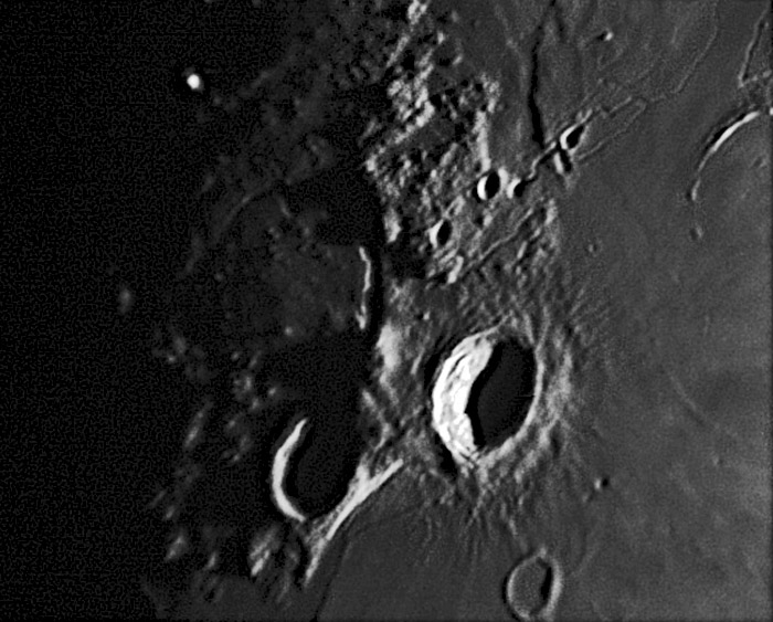
I love images near the terminator because of the subtle topography they reveal. In this case we graphically see what altimetry profiles have said earlier, but a picture is much more influential than a graph line. West of Aristarchus Crater is the Cobra Head, the source vent - a depression - of the lavas that carved Schröter's Valley. But what has been glimpsed from time to time and documented with the LRO QuickMap altimetry tool is that the Cobra Head is a deep depression on the side of a massive mountain. Raf's image shows a wide and long shadow that emphasizes the height and shape of the Cobra Mountain. The LRO altimetry shows that the mountain is 40 km wide and 2 km high. This fact was recognized in a previous [http://lpod.wikispaces.com/August+20,+2012 LPOD] based on Maurice Collins' early processing of low-Sun LRO images. Millions of dollars for a spacecraft and teams of data processors, or one amateur with a 7" backyard telescope.<br /> | I love images near the terminator because of the subtle topography they reveal. In this case we graphically see what altimetry profiles have said earlier, but a picture is much more influential than a graph line. West of Aristarchus Crater is the Cobra Head, the source vent - a depression - of the lavas that carved Schröter's Valley. But what has been glimpsed from time to time and documented with the LRO QuickMap altimetry tool is that the Cobra Head is a deep depression on the side of a massive mountain. Raf's image shows a wide and long shadow that emphasizes the height and shape of the Cobra Mountain. The LRO altimetry shows that the mountain is 40 km wide and 2 km high. This fact was recognized in a previous [http://lpod.wikispaces.com/August+20,+2012 LPOD] based on Maurice Collins' early processing of low-Sun LRO images. Millions of dollars for a spacecraft and teams of data processors, or one amateur with a 7" backyard telescope.<br /> | ||
<br /> | <br /> | ||
| − | <em>[mailto:tychocrater@yahoo.com | + | <em>[mailto:tychocrater@yahoo.com Chuck Wood]</em><br /> |
<br /> | <br /> | ||
<strong>Technical Details</strong><br /> | <strong>Technical Details</strong><br /> | ||
Revision as of 20:08, 17 January 2015
A Mountainous Shadow

image by Raf Lena, Italia
I love images near the terminator because of the subtle topography they reveal. In this case we graphically see what altimetry profiles have said earlier, but a picture is much more influential than a graph line. West of Aristarchus Crater is the Cobra Head, the source vent - a depression - of the lavas that carved Schröter's Valley. But what has been glimpsed from time to time and documented with the LRO QuickMap altimetry tool is that the Cobra Head is a deep depression on the side of a massive mountain. Raf's image shows a wide and long shadow that emphasizes the height and shape of the Cobra Mountain. The LRO altimetry shows that the mountain is 40 km wide and 2 km high. This fact was recognized in a previous LPOD based on Maurice Collins' early processing of low-Sun LRO images. Millions of dollars for a spacecraft and teams of data processors, or one amateur with a 7" backyard telescope.
Chuck Wood
Technical Details
June 9 2014, 20:12 UT. Mak-Cass 18 cm
Related Links
21st Century Atlas chart 28.


