Difference between revisions of "June 10, 2004"
(Created page with "__NOTOC__ =Peaks of Plato= ---- ===COMMENTS?=== Click on this icon image:PostIcon.jpg at the upper right to post a comment.") |
|||
| (13 intermediate revisions by the same user not shown) | |||
| Line 1: | Line 1: | ||
__NOTOC__ | __NOTOC__ | ||
=Peaks of Plato= | =Peaks of Plato= | ||
| − | + | <!-- Start of content --> | |
| − | + | <table width="640" border="0" align="center" cellpadding="4" cellspacing="2"> | |
| − | + | <tr> | |
| − | ---- | + | </tr> |
| − | === | + | </table> |
| − | + | <table width="640" border="0" align="center" cellpadding="6" cellspacing="2"> | |
| + | <tr> | ||
| + | <td> | ||
| + | <div align="center"> | ||
| + | <!-- Mouse style 3 --> | ||
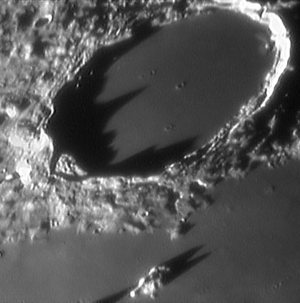
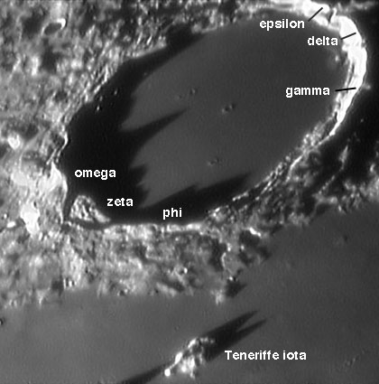
| + | {{HoverImage|LPOD-2004-06-10.jpeg|LPOD-2004-06-10b.jpeg}} | ||
| + | </div></td> | ||
| + | </tr> | ||
| + | </table> | ||
| + | <p class="main_sm" align="center">Image Credit: [mailto:starman2@flash.net Wes Higgins]</p> | ||
| + | <table class="story" border="0" bgcolor="#FFFFFF" width="90%" cellpadding="10" align="center"> | ||
| + | <tr> | ||
| + | <td><p class="Story" align="center"><b>Peaks of Plato</b></p> | ||
| + | <p class="story" align="left"> | ||
| + | The Moon always repays observation. For sociological reasons (sleep and jobs), Plato is commonly studied before | ||
| + | midnight, and so the sunrise view with shadows cast by peaks on the eastern ramparts is most familiar. But this | ||
| + | wonderful sunset view, taken when the Moon was about 23 days old, reveals long shadows from the western peaks | ||
| + | that most of us never see. The longest shadow is about 45 km long; Plato is 101 km wide. Surprisingly, this | ||
| + | tallest peak on the western rim doesn't have a Greek letter designation. Most of the Greek letters for lunar | ||
| + | mountains were given by [[January_16,_2004|Madler]] and Neison, but all are ignored by the | ||
| + | International Astronomical Union because of the difficulty in identifying them. If you mouse over the image | ||
| + | above you will see the Greek letters for Plato's rim, taken from the Blagg and Muller IAU map of 1935. I have | ||
| + | added two (totally unofficial) additional Greek letters - omega and phi - for the two tallest peaks on Plato's | ||
| + | western rim, which strangely lacked letters. The large rim collapse segment was labeled zeta by Madler. There are | ||
| + | no spacecraft heights for these peaks that I am aware of , but the US Air Force Chart and Aeronautical Center | ||
| + | maps (available most readily in <I>The Times Altas of the Moon</I>, 1969) include the following heights derived | ||
| + | from shadow measurements made in the 1960s.</p> | ||
| + | <div align="center"> | ||
| + | <TABLE CELLSPACING=2 CELLPADDING=2 BORDER=1> | ||
| + | <TR BGCOLOR="GRAY"><TD><CENTER>Peak </CENTER></TD> | ||
| + | <TD><CENTER>Height</CENTER></TD> | ||
| + | </TR> | ||
| + | <TR><TD><CENTER>delta</CENTER></TD> | ||
| + | <TD><CENTER>2440 m</CENTER></TD> | ||
| + | </TR> | ||
| + | <TR><TD><CENTER>omega</CENTER></TD> | ||
| + | <TD><CENTER>2300 m</CENTER></TD> | ||
| + | </TR> | ||
| + | <TR><TD><CENTER>gamma</CENTER></TD> | ||
| + | <TD><CENTER>2140 m</CENTER></TD> | ||
| + | </TR> | ||
| + | <TR><TD><CENTER>phi</CENTER></TD> | ||
| + | <TD><CENTER>1870 m</CENTER></TD> | ||
| + | </TR> | ||
| + | <TR><TD><CENTER>epsilon</CENTER></TD> | ||
| + | <TD><CENTER>1790 m</CENTER></TD> | ||
| + | </TR> | ||
| + | <TR><TD><CENTER>zeta</CENTER></TD> | ||
| + | <TD><CENTER>1310 m</CENTER></TD> | ||
| + | </TR> | ||
| + | </TABLE> | ||
| + | </div> | ||
| + | <p>As I stated recently there is need for modern determinations/confirmations of peak | ||
| + | [[February_4,_2004|heights]], which will require figuring our peak | ||
| + | [[February_4,_2004|nomenclature]]. The IAU isn't going to do it!</p> | ||
| + | <p><b>Technical Details: </b><br> | ||
| + | Plato on 10/18/03. This is a stack of 224 frames from 600, taken with a Starmaster 14.5 F/4.3 working at F/28, Toucam Pro Webcam, 10FPS, stacked and processed in Registax.</p> | ||
| + | <p class="story" align="left"><i>Originally posted March 15, 2004 </i></p> | ||
| + | <p class="story" align="left"><b>Related Links:</b><br> | ||
| + | [http://www.licha.de/AstroWeb/gallery_fullsize.php3?iBPId=131&iSOId=7 Images by Wes Higgins]<br> | ||
| + | [http://www.glrgroup.org/papers/13.htm Plato Gamma Shadow] | ||
| + | </p> | ||
| + | <p><b>Yesterday's LPOD:</b> [[June 9, 2004|Color Map]] </p> | ||
| + | <p><b>Tomorrow's LPOD:</b> [[June 11, 2004|Pitatus]] </p> | ||
| + | </tr> | ||
| + | </table> | ||
| + | <hr width="640" align="center"> | ||
| + | <p align="center" class="main_titles"><b>Author & Editor:</b><br> | ||
| + | [mailto:tychocrater@yahoo.com Charles A. Wood]</p> | ||
| + | <!-- Cleanup of credits --> | ||
| + | <!-- Cleanup of credits --> | ||
| + | <!-- Cleanup of credits --> | ||
| + | <!-- Cleanup of credits --> | ||
| + | <!-- Cleanup of credits --> | ||
| + | <!-- Cleanup of credits --> | ||
| + | <!-- Cleanup of credits --> | ||
| + | <p> </p> | ||
| + | <!-- End of content --> | ||
| + | {{wiki/ArticleFooter}} | ||
Latest revision as of 10:23, 6 June 2015
Peaks of Plato
Image Credit: Wes Higgins
Peaks of Plato The Moon always repays observation. For sociological reasons (sleep and jobs), Plato is commonly studied before midnight, and so the sunrise view with shadows cast by peaks on the eastern ramparts is most familiar. But this wonderful sunset view, taken when the Moon was about 23 days old, reveals long shadows from the western peaks that most of us never see. The longest shadow is about 45 km long; Plato is 101 km wide. Surprisingly, this tallest peak on the western rim doesn't have a Greek letter designation. Most of the Greek letters for lunar mountains were given by Madler and Neison, but all are ignored by the International Astronomical Union because of the difficulty in identifying them. If you mouse over the image above you will see the Greek letters for Plato's rim, taken from the Blagg and Muller IAU map of 1935. I have added two (totally unofficial) additional Greek letters - omega and phi - for the two tallest peaks on Plato's western rim, which strangely lacked letters. The large rim collapse segment was labeled zeta by Madler. There are no spacecraft heights for these peaks that I am aware of , but the US Air Force Chart and Aeronautical Center maps (available most readily in The Times Altas of the Moon, 1969) include the following heights derived from shadow measurements made in the 1960s. As I stated recently there is need for modern determinations/confirmations of peak heights, which will require figuring our peak nomenclature. The IAU isn't going to do it! Technical Details: Originally posted March 15, 2004 Related Links: Yesterday's LPOD: Color Map Tomorrow's LPOD: Pitatus |
Author & Editor:
Charles A. Wood
COMMENTS?
Register, Log in, and join in the comments.


