Difference between revisions of "July 6, 2004"
| (8 intermediate revisions by the same user not shown) | |||
| Line 1: | Line 1: | ||
__NOTOC__ | __NOTOC__ | ||
=A Long Graben= | =A Long Graben= | ||
| + | <!-- Start of content --> | ||
<table width="85%" border="0" align="center" cellpadding="6" cellspacing="2"> | <table width="85%" border="0" align="center" cellpadding="6" cellspacing="2"> | ||
<tr> | <tr> | ||
| Line 8: | Line 9: | ||
<tr> | <tr> | ||
<td colspan="2"><div align="center"> | <td colspan="2"><div align="center"> | ||
| − | + | {{HoverImage|LPOD-2004-07-06.jpeg|LPOD-2004-07-06b.jpeg}} | |
</div></td> | </div></td> | ||
</tr> | </tr> | ||
| Line 14: | Line 15: | ||
<table width="100%" border="0" cellpadding="8"> | <table width="100%" border="0" cellpadding="8"> | ||
<tr> | <tr> | ||
| − | <td><div align="center | + | <td><div align="center"><p>Image Credit: [mailto:tbash@ptd.net Tom Bash ]</p></div></td> |
</tr> | </tr> | ||
</table> | </table> | ||
| Line 20: | Line 21: | ||
<p class="story" align="center"><b>A Long Graben</b></p> | <p class="story" align="center"><b>A Long Graben</b></p> | ||
<p class="story" align="left"> | <p class="story" align="left"> | ||
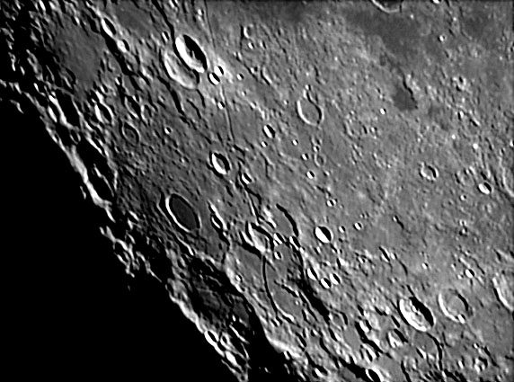
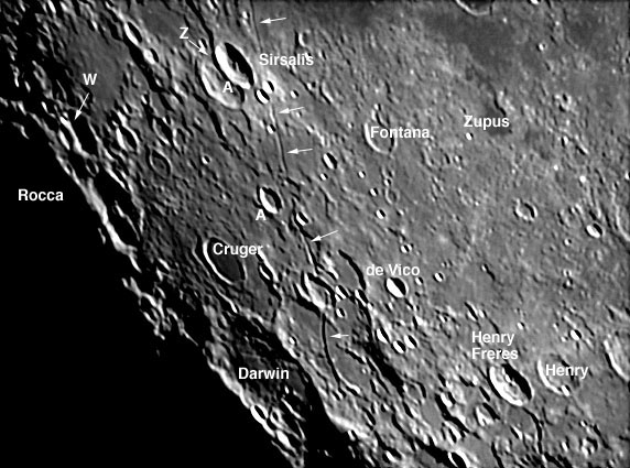
| − | Graben is a German word meaning ditch or trough. Geologically, graben form by the dropping downward of a linear block between two parallel faults. Terrestrial graben typically occur in regions of extension - where forces pull the surface apart in directions perpendicular to the resulting graben. This image shows the long linear Sirsalis Rrille, which appears to be lunar graben. High resolution Lunar Orbiter images show that the rille widens where it cuts topographically high land, implying that its side faults steeply dip at an angle of about 60 degrees from the horizontal. Jim Head and Lionel Wilson propose that the extension that allows lunar graben to form is due to the displacement of the crust due to the rise of a dike (or dyke for UK readers) that carries magma toward the surface. At the Parry Rille, near Fra Mauro, the dike reached the surface, constructing small cones and spreading pyroclastic material. There is no evidence of associated volcanism along the Sirsalis Rille so that dike solidified before its magma reached the lunar surface. From the width (about 4 km maximum) and depth (230 m) Head and Wilson calculate that the dike that formed the Sirsalis Rille is about 600 - 700 m wide and rose to about 2.4 km below the surface. This dikes is amazing for it rose nearly 100 km from its source of magma! And remember that the Sirsalis Rille is about 350-400 km long, so its dike must be a thin sheet of magma that slices thru the lunar crust and upper mantle. Amazing! specially if true! And it is probably true, for one of the strongest magnetic fields on the Moon traces the Sirsalis Rille - its solidified dike must be the source of the magnetic field. | + | Graben is a German word meaning ditch or trough. Geologically, graben form by the dropping downward of a linear block between two parallel faults. Terrestrial graben typically occur in regions of extension - where forces pull the surface apart in directions perpendicular to the resulting graben. This image shows the long linear Sirsalis Rrille, which appears to be lunar graben. High resolution Lunar Orbiter images show that the rille widens where it cuts topographically high land, implying that its side faults steeply dip at an angle of about 60 degrees from the horizontal. Jim Head and Lionel Wilson propose that the extension that allows lunar graben to form is due to the displacement of the crust due to the rise of a dike (or dyke for UK readers) that carries magma toward the surface. At the Parry Rille, near Fra Mauro, the dike reached the surface, constructing small cones and spreading pyroclastic material. There is no evidence of associated volcanism along the Sirsalis Rille so that dike solidified before its magma reached the lunar surface. From the width (about 4 km maximum) and depth (230 m) Head and Wilson calculate that the dike that formed the Sirsalis Rille is about 600 - 700 m wide and rose to about 2.4 km below the surface. This dikes is amazing for it rose nearly 100 km from its source of magma! And remember that the Sirsalis Rille is about 350-400 km long, so its dike must be a thin sheet of magma that slices thru the lunar crust and upper mantle. Amazing! specially if true! And it is probably true, for one of the strongest magnetic fields on the Moon traces the Sirsalis Rille - its solidified dike must be the source of the magnetic field.</p> |
<blockquote> | <blockquote> | ||
| − | <p align="right" class="story">— [mailto:tychocrater@yahoo.com Chuck Wood]</ | + | <p align="right" class="story">— [mailto:tychocrater@yahoo.com Chuck Wood]</p></blockquote> |
| − | </ | ||
<p class="story" align="left"><b>Technical Details:</b><br> | <p class="story" align="left"><b>Technical Details:</b><br> | ||
| − | March 4, 2004, using a C11 with a ToUcam web cam. | + | March 4, 2004, using a C11 with a ToUcam web cam.</p> |
<p class="story" align="left"><b>Related Links: </b><br> | <p class="story" align="left"><b>Related Links: </b><br> | ||
Head & Wilson (1993) Lunar graben formation due to near-surface deformation accompanying dike emplacement. <i>Planet. Space Sci.</i> 41, 719-727.<br> | Head & Wilson (1993) Lunar graben formation due to near-surface deformation accompanying dike emplacement. <i>Planet. Space Sci.</i> 41, 719-727.<br> | ||
| − | [http://www.lpi.usra.edu/research/lunar_orbiter/bin/info.shtml?459 Lunar Orbiter IV View] | + | [http://www.lpi.usra.edu/research/lunar_orbiter/bin/info.shtml?459 Lunar Orbiter IV View] </p> |
| − | <p | + | <p><b>Yesterday's LPOD:</b> [[July 5, 2004|Insularum Interlude]] </p> |
| + | <p><b>Tomorrow's LPOD:</b> [[July 7, 2004|Transient TLP]] </p> | ||
</tr> | </tr> | ||
</table> | </table> | ||
| Line 40: | Line 41: | ||
<td><p align="center" class="main_titles"><b>Author & Editor:</b><br> | <td><p align="center" class="main_titles"><b>Author & Editor:</b><br> | ||
[mailto:tychocrater@yahoo.com Charles A. Wood]</p> | [mailto:tychocrater@yahoo.com Charles A. Wood]</p> | ||
| − | < | + | <!-- Cleanup of credits --> |
| − | + | <!-- Cleanup of credits --> | |
| − | < | + | <!-- Cleanup of credits --> |
| − | + | <!-- Cleanup of credits --> | |
| − | < | + | <!-- Cleanup of credits --> |
| − | + | <!-- Cleanup of credits --> | |
| + | <!-- Cleanup of credits --> | ||
</tr> | </tr> | ||
</table> | </table> | ||
| Line 51: | Line 53: | ||
<div align="center"></div> | <div align="center"></div> | ||
<p> </p> | <p> </p> | ||
| − | ---- | + | <!-- End of content --> |
| − | + | {{wiki/ArticleFooter}} | |
| − | |||
Latest revision as of 19:21, 7 February 2015
A Long Graben
Image Credit: Tom Bash |
|
A Long Graben Graben is a German word meaning ditch or trough. Geologically, graben form by the dropping downward of a linear block between two parallel faults. Terrestrial graben typically occur in regions of extension - where forces pull the surface apart in directions perpendicular to the resulting graben. This image shows the long linear Sirsalis Rrille, which appears to be lunar graben. High resolution Lunar Orbiter images show that the rille widens where it cuts topographically high land, implying that its side faults steeply dip at an angle of about 60 degrees from the horizontal. Jim Head and Lionel Wilson propose that the extension that allows lunar graben to form is due to the displacement of the crust due to the rise of a dike (or dyke for UK readers) that carries magma toward the surface. At the Parry Rille, near Fra Mauro, the dike reached the surface, constructing small cones and spreading pyroclastic material. There is no evidence of associated volcanism along the Sirsalis Rille so that dike solidified before its magma reached the lunar surface. From the width (about 4 km maximum) and depth (230 m) Head and Wilson calculate that the dike that formed the Sirsalis Rille is about 600 - 700 m wide and rose to about 2.4 km below the surface. This dikes is amazing for it rose nearly 100 km from its source of magma! And remember that the Sirsalis Rille is about 350-400 km long, so its dike must be a thin sheet of magma that slices thru the lunar crust and upper mantle. Amazing! specially if true! And it is probably true, for one of the strongest magnetic fields on the Moon traces the Sirsalis Rille - its solidified dike must be the source of the magnetic field. Technical Details: Related Links: Yesterday's LPOD: Insularum Interlude Tomorrow's LPOD: Transient TLP |
Author & Editor: |
COMMENTS?
Register, Log in, and join in the comments.


