Difference between revisions of "July 21, 2010"
| Line 2: | Line 2: | ||
=More Than Circular?= | =More Than Circular?= | ||
| − | + | <!-- ws:start:WikiTextHeadingRule:1:<h1> --> | |
| − | + | <!-- ws:start:WikiTextLocalImageRule:16:<img src="/file/view/LPOD-July21-10.jpg/153387169/LPOD-July21-10.jpg" alt="" title="" /> -->[[File:LPOD-July21-10.jpg|LPOD-July21-10.jpg]]<!-- ws:end:WikiTextLocalImageRule:16 --><br /> | |
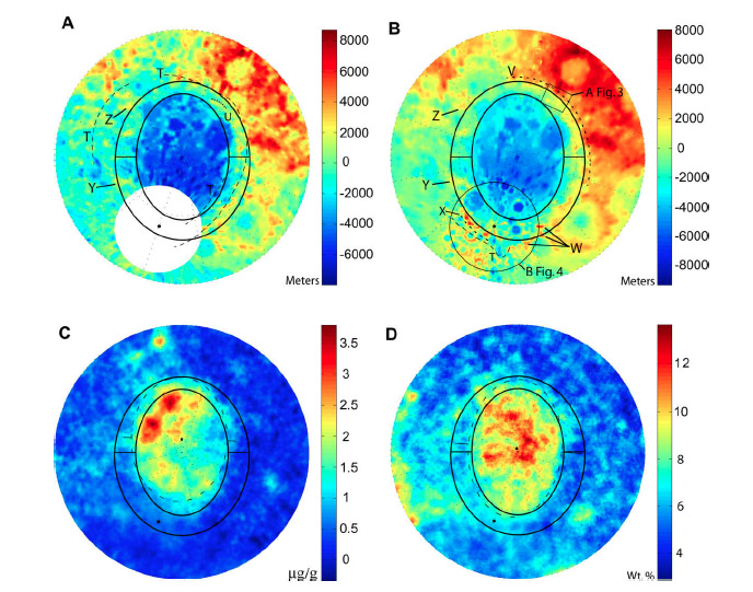
<em>image from [mailto:iang@mit.edu Garrick-Bethell] and Zuber (2009) Icarus. A is Clementine-derived topography; B is ULCN2005 topo, C is thorium abundance; and D is iron abundance. The white circle in A is where data are unavailable, and the bLack circle in B marks the same area.</em><br /> | <em>image from [mailto:iang@mit.edu Garrick-Bethell] and Zuber (2009) Icarus. A is Clementine-derived topography; B is ULCN2005 topo, C is thorium abundance; and D is iron abundance. The white circle in A is where data are unavailable, and the bLack circle in B marks the same area.</em><br /> | ||
<br /> | <br /> | ||
| Line 14: | Line 14: | ||
<br /> | <br /> | ||
<hr /> | <hr /> | ||
| − | + | <div>You can support LPOD when you buy any book from Amazon thru [http://www.lpod.org/?page_id=591 LPOD!]<br /> | |
| − | < | + | </div> |
| − | |||
| − | |||
| − | |||
---- | ---- | ||
===COMMENTS?=== | ===COMMENTS?=== | ||
Click on this icon [[image:PostIcon.jpg]] at the upper right to post a comment. | Click on this icon [[image:PostIcon.jpg]] at the upper right to post a comment. | ||
Revision as of 21:09, 2 January 2015
More Than Circular?

image from Garrick-Bethell and Zuber (2009) Icarus. A is Clementine-derived topography; B is ULCN2005 topo, C is thorium abundance; and D is iron abundance. The white circle in A is where data are unavailable, and the bLack circle in B marks the same area.
The shapes and sizes of old impact basins are often difficult to define because they have been strongly modified by later events. The oldest (or perhaps second oldest if the Procellarum Basin is real) basin, South Pole-Aitken (SPA) falls into the category of difficult to define. A few pieces of its putative rim show up as large isolated mountains, or massifs, near the South Pole, a beautiful, but short arc was imaged by the Apollo 8 crew, and topo maps reveal a 90° scarp (the edge of the red) at upper right in map B above. In 2009, MIT researchers Garrick-Bethell and Zuber identified edges in maps of three data sets - topography, iron and thorium abundances. They then made a statistical fit to these boundary points and determined that SPA is elliptical, not circular in outline. In the maps above they include both their original elliptical outline (inner ellipses) and an outer one that is mostly defined by the 90° scarp. Because the SPA outline is elliptical, Garrick-Bethell and Zuber conclude that the giant basin formed by an oblique impact, with the projectile perhaps coming from the south. This careful analysis was conducted with relatively sparse topographic data from Clementine; the new high resolution LRO altimetry data have led to different speculations - more thorough studies are needed.
Chuck Wood
Related Links
Ian Garrick-Bethell and Maria Zuber (2009) Elliptical structure of the lunar South Pole-Aitken basin, Icarus, Volume 204, Issue 2, p. 399-408.
COMMENTS?
Click on this icon File:PostIcon.jpg at the upper right to post a comment.


