Difference between revisions of "July 11, 2014"
| Line 1: | Line 1: | ||
__NOTOC__ | __NOTOC__ | ||
=Name That Dome= | =Name That Dome= | ||
| − | |||
<!-- ws:start:WikiTextHeadingRule:0:<h1> --> | <!-- ws:start:WikiTextHeadingRule:0:<h1> --> | ||
<!-- ws:start:WikiTextLocalImageRule:6:<img src="/file/view/LPOD-Jul11-14.jpg/516006170/LPOD-Jul11-14.jpg" alt="" title="" /> -->[[File:LPOD-Jul11-14.jpg|LPOD-Jul11-14.jpg]]<!-- ws:end:WikiTextLocalImageRule:6 --><br /> | <!-- ws:start:WikiTextLocalImageRule:6:<img src="/file/view/LPOD-Jul11-14.jpg/516006170/LPOD-Jul11-14.jpg" alt="" title="" /> -->[[File:LPOD-Jul11-14.jpg|LPOD-Jul11-14.jpg]]<!-- ws:end:WikiTextLocalImageRule:6 --><br /> | ||
| − | <em>images from [http://lunardomeatlas.blogspot.it GLR Lunar Domes Atlas]</em><br /> | + | <em>images from [http://lunardomeatlas.blogspot.it" rel="nofollow GLR Lunar Domes Atlas]</em><br /> |
<br /> | <br /> | ||
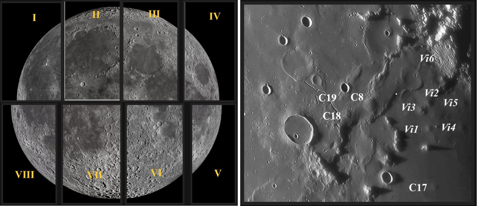
The International Astronomical Union nomenclature group pretty much gave up on comprehensive nomenclature for peaks, domes and rilles back in 1973. Today only a few of the hundreds of such landforms have formal names. But the Geologic Lunar Research group's catalog provides a good listing for domes, and now Raf Lena and others of the group are presenting basic dome information in a new online <em>Lunar Domes Atlas</em> that is free and easy to use. The right image above illustrates part of what the <em>Atlas</em> contains, in this case an excellent image from Paolo Lazzarotti, annotated with the designations of the recognized domes in the area. The left image shows the 8 quadrants (of the LRO nearside map) that the <em>Atlas</em> divides the lunar nearside into to provide structure for the arrangement of the data. Below each image is a listing of dome position, diameter, height, and slope, and a short text that gives a general description of each dome. Nearly all of the images and dimensions come from the GLR's work, and the nomenclature grew out of earlier catalogs from the ALPO and BAA. Raf stresses that the <em>Atlas</em> is dynamic in that it will be updated with improved images and data as they become available. This is a valuable new resource.<br /> | The International Astronomical Union nomenclature group pretty much gave up on comprehensive nomenclature for peaks, domes and rilles back in 1973. Today only a few of the hundreds of such landforms have formal names. But the Geologic Lunar Research group's catalog provides a good listing for domes, and now Raf Lena and others of the group are presenting basic dome information in a new online <em>Lunar Domes Atlas</em> that is free and easy to use. The right image above illustrates part of what the <em>Atlas</em> contains, in this case an excellent image from Paolo Lazzarotti, annotated with the designations of the recognized domes in the area. The left image shows the 8 quadrants (of the LRO nearside map) that the <em>Atlas</em> divides the lunar nearside into to provide structure for the arrangement of the data. Below each image is a listing of dome position, diameter, height, and slope, and a short text that gives a general description of each dome. Nearly all of the images and dimensions come from the GLR's work, and the nomenclature grew out of earlier catalogs from the ALPO and BAA. Raf stresses that the <em>Atlas</em> is dynamic in that it will be updated with improved images and data as they become available. This is a valuable new resource.<br /> | ||
<br /> | <br /> | ||
| − | <em>[mailto:tychocrater@yahoo.com Chuck Wood]</em><br /> | + | <em>[mailto:tychocrater@yahoo.com" rel="nofollow Chuck Wood]</em><br /> |
<br /> | <br /> | ||
<hr /> | <hr /> | ||
Revision as of 23:01, 4 January 2015
Name That Dome

images from " rel="nofollow GLR Lunar Domes Atlas
The International Astronomical Union nomenclature group pretty much gave up on comprehensive nomenclature for peaks, domes and rilles back in 1973. Today only a few of the hundreds of such landforms have formal names. But the Geologic Lunar Research group's catalog provides a good listing for domes, and now Raf Lena and others of the group are presenting basic dome information in a new online Lunar Domes Atlas that is free and easy to use. The right image above illustrates part of what the Atlas contains, in this case an excellent image from Paolo Lazzarotti, annotated with the designations of the recognized domes in the area. The left image shows the 8 quadrants (of the LRO nearside map) that the Atlas divides the lunar nearside into to provide structure for the arrangement of the data. Below each image is a listing of dome position, diameter, height, and slope, and a short text that gives a general description of each dome. Nearly all of the images and dimensions come from the GLR's work, and the nomenclature grew out of earlier catalogs from the ALPO and BAA. Raf stresses that the Atlas is dynamic in that it will be updated with improved images and data as they become available. This is a valuable new resource.
" rel="nofollow Chuck Wood


