Difference between revisions of "January 11, 2013"
| Line 11: | Line 11: | ||
and hilly terrain that is the intermediate ring. These two inner rings are not the narrow, ideal rings that we might suppose | and hilly terrain that is the intermediate ring. These two inner rings are not the narrow, ideal rings that we might suppose | ||
exist under Imbrium lavas that are marked by mare ridges and isolated peaks. They are more like the wide Inner and Outer | exist under Imbrium lavas that are marked by mare ridges and isolated peaks. They are more like the wide Inner and Outer | ||
| − | Rook Mountains of [http://lpod. | + | Rook Mountains of [http://www2.lpod.org/wiki/January_11,_2008 Orientale], but eroded by many more later impacts and their ejecta. The moats between the Nectaris |
rings are less rough than the ring areas, and while the outer moat fronting the Altai is about flat, according to the Path tool | rings are less rough than the ring areas, and while the outer moat fronting the Altai is about flat, according to the Path tool | ||
of LRO QuickMap, the inner moat tilts down 1200 m towards the basin center. In fact, there has been little study of the | of LRO QuickMap, the inner moat tilts down 1200 m towards the basin center. In fact, there has been little study of the | ||
| Line 24: | Line 24: | ||
<strong>Related Links</strong><br /> | <strong>Related Links</strong><br /> | ||
Rükl plate [https://the-moon.us/wiki/R%C3%BCkl_57 57]<br /> | Rükl plate [https://the-moon.us/wiki/R%C3%BCkl_57 57]<br /> | ||
| − | <em>[ | + | <em>[[21st Century Atlas of the Moon|21st Century Atlas]]</em> chart 6.<br /> |
<br /> | <br /> | ||
<p><b>Yesterday's LPOD:</b> [[January 10, 2013|Full Moon Last Quarter]] </p> | <p><b>Yesterday's LPOD:</b> [[January 10, 2013|Full Moon Last Quarter]] </p> | ||
Latest revision as of 08:27, 28 October 2018
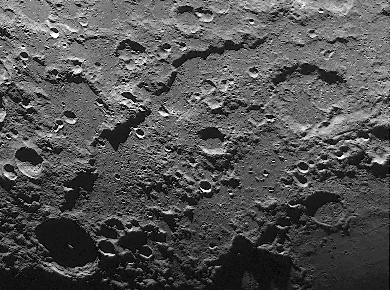
Battered Rings

image by Claude Navarro, Toulouse, France
Do you see three basin rings? The shadow-casting Altai Scarp is the topographic equivalent to the Apennines at Imbrium
and the Cordillera surrounding Orientale. At the bottom right corner more shadows are cast by Fracastorius and Beaumont,
and between them are hints of a basin ring made by hills. Between the Altai and this inner ring is a broad arc of elevated
and hilly terrain that is the intermediate ring. These two inner rings are not the narrow, ideal rings that we might suppose
exist under Imbrium lavas that are marked by mare ridges and isolated peaks. They are more like the wide Inner and Outer
Rook Mountains of Orientale, but eroded by many more later impacts and their ejecta. The moats between the Nectaris
rings are less rough than the ring areas, and while the outer moat fronting the Altai is about flat, according to the Path tool
of LRO QuickMap, the inner moat tilts down 1200 m towards the basin center. In fact, there has been little study of the
variations in morphology of inner basin rings so we don't know how to explain wide versus narrow rings.
Chuck Wood
Technical Details
Oct/05/2012. C14 + Basler 1300 + IR Pass 742 filter. Processing with Registax 6 (250 Images on 2000).
Related Links
Rükl plate 57
21st Century Atlas chart 6.
Yesterday's LPOD: Full Moon Last Quarter
Tomorrow's LPOD: Building the 21st Century Lunar Map
COMMENTS?
Register, Log in, and join in the comments.


