Difference between revisions of "February 17, 2008"
| Line 7: | Line 7: | ||
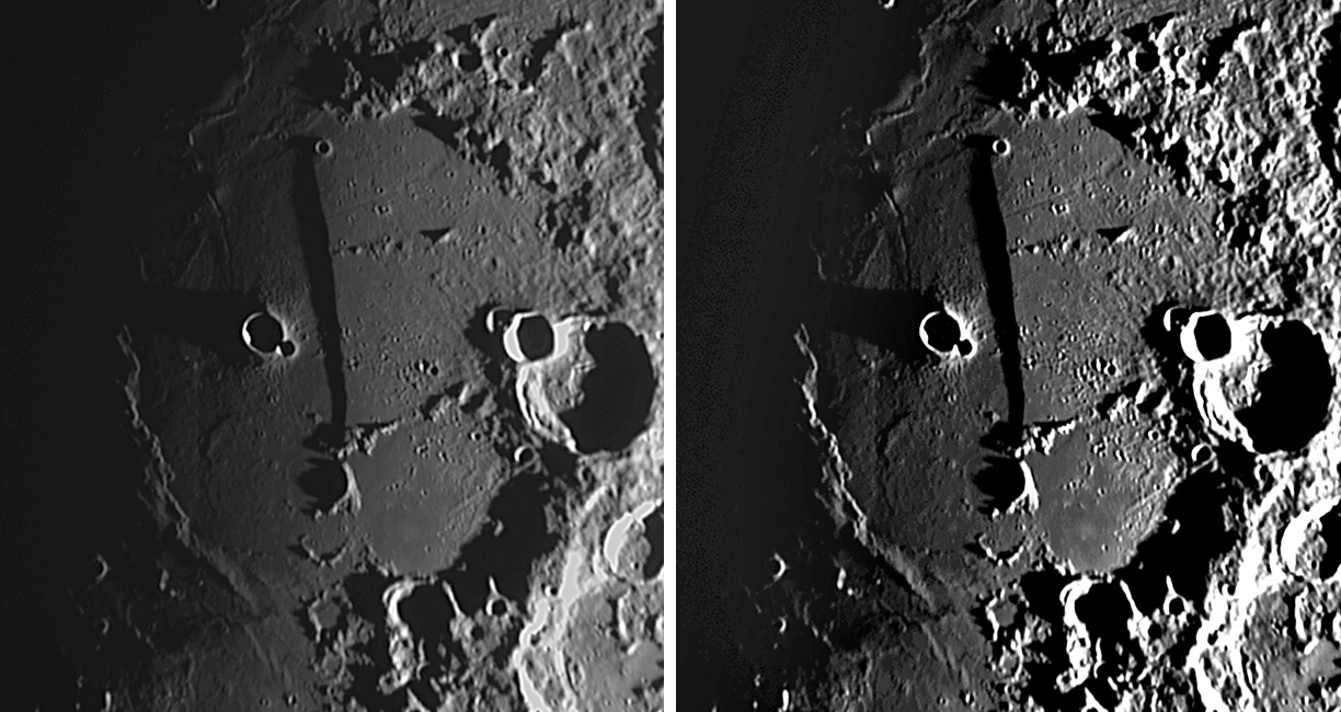
<em>image by [mailto:thefamily90@hotmail.com Jim Phillips;] original image on left, CAW hyper-enhancement at right</em><br /> | <em>image by [mailto:thefamily90@hotmail.com Jim Phillips;] original image on left, CAW hyper-enhancement at right</em><br /> | ||
<br /> | <br /> | ||
| − | This is the most dramatic image of the Straight Wall that I've ever seen. Jim's diligence at imaging as close to the terminator as possible has reaped great rewards with this image. The long shadow cast by the fault will be analyzed by the [http://www.glrgroup.org/home.htm GRL] team to study the details of the fault height, but it clearly is higher to the north. There are many subtle topographic features exposed in this image. (1) The rille on the northeast side of the fault and nearly at right angles to it starts with two shallow crater-like depressions and then narrows as it approaches the fault; there is no evidence that it continued beyond the scarp. (2) Both of the domes at the north end of the Birt Rille cast shadows, hopefully allowing their heights to be determined. (3) The straight and narrow [ | + | This is the most dramatic image of the Straight Wall that I've ever seen. Jim's diligence at imaging as close to the terminator as possible has reaped great rewards with this image. The long shadow cast by the fault will be analyzed by the [http://www.glrgroup.org/home.htm GRL] team to study the details of the fault height, but it clearly is higher to the north. There are many subtle topographic features exposed in this image. (1) The rille on the northeast side of the fault and nearly at right angles to it starts with two shallow crater-like depressions and then narrows as it approaches the fault; there is no evidence that it continued beyond the scarp. (2) Both of the domes at the north end of the Birt Rille cast shadows, hopefully allowing their heights to be determined. (3) The straight and narrow [[February_7,_2004|crease]] southwest of Birt is well seen, but still mysterious in origin. (4) The line of hills from the south end of the fault to Thebit, and the matching line to the north [[April_8,_2007|Messier]]. This would imply that the projectile came from the east or west. A low Sun view with sunset illumination would confirm the distribution of Birt's ejecta.<br /> |
<br /> | <br /> | ||
<em>Chuck Wood</em><br /> | <em>Chuck Wood</em><br /> | ||
| Line 17: | Line 17: | ||
<strong>Related Links</strong><br /> | <strong>Related Links</strong><br /> | ||
Rükl plate 54<br /> | Rükl plate 54<br /> | ||
| − | Jim's earlier [ | + | Jim's earlier [[April_8,_2007|view]] with even lower Sun<br /> |
<br /> | <br /> | ||
<br /> | <br /> | ||
Latest revision as of 22:10, 22 March 2015
Cornucopia of Details

image by Jim Phillips; original image on left, CAW hyper-enhancement at right
This is the most dramatic image of the Straight Wall that I've ever seen. Jim's diligence at imaging as close to the terminator as possible has reaped great rewards with this image. The long shadow cast by the fault will be analyzed by the GRL team to study the details of the fault height, but it clearly is higher to the north. There are many subtle topographic features exposed in this image. (1) The rille on the northeast side of the fault and nearly at right angles to it starts with two shallow crater-like depressions and then narrows as it approaches the fault; there is no evidence that it continued beyond the scarp. (2) Both of the domes at the north end of the Birt Rille cast shadows, hopefully allowing their heights to be determined. (3) The straight and narrow crease southwest of Birt is well seen, but still mysterious in origin. (4) The line of hills from the south end of the fault to Thebit, and the matching line to the north Messier. This would imply that the projectile came from the east or west. A low Sun view with sunset illumination would confirm the distribution of Birt's ejecta.
Chuck Wood
Technical Details
Feb. 14, 2008. TMB 8" F/9 @ F/27
This image was acquired with the aid of Alexandria, Jim's 4 year old neighbor who is becoming mesmerized with the Moon.
Related Links
Rükl plate 54
Jim's earlier view with even lower Sun
Yesterday's LPOD: A Simple Scene
Tomorrow's LPOD: Lucky Eclipse Pair
COMMENTS?
Register, Log in, and join in the comments.


