Difference between revisions of "February 11, 2009"
| Line 3: | Line 3: | ||
<!-- ws:start:WikiTextHeadingRule:2:<h1> --> | <!-- ws:start:WikiTextHeadingRule:2:<h1> --> | ||
<!-- ws:start:WikiTextLocalImageRule:8:<img src="/file/view/LPOD-Feb11-09.jpg/57328554/800x685/LPOD-Feb11-09.jpg" alt="" title="" style="height: 685px; width: 800px;" /> -->[[File:LPOD-Feb11-09.jpg|LPOD-Feb11-09.jpg]]<!-- ws:end:WikiTextLocalImageRule:8 --><br /> | <!-- ws:start:WikiTextLocalImageRule:8:<img src="/file/view/LPOD-Feb11-09.jpg/57328554/800x685/LPOD-Feb11-09.jpg" alt="" title="" style="height: 685px; width: 800px;" /> -->[[File:LPOD-Feb11-09.jpg|LPOD-Feb11-09.jpg]]<!-- ws:end:WikiTextLocalImageRule:8 --><br /> | ||
| − | <em>south up image by [mailto:c.zannelli@virgilio.it | + | <em>south up image by [mailto:c.zannelli@virgilio.it Carmelo Mel Zannelli], Palermo, Italy </em><br /> |
<br /> | <br /> | ||
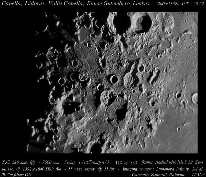
| − | At this lighting [http://www.lpod.org/?m=20060418 | + | At this lighting [http://www.lpod.org/?m=20060418 Terra Manna] is just a jumble of old craters, rilles, and odd spaces. It does include [http://www.lpod.org/?m=20061210 two rings] of the Nectaris Basin but they are hard to identify. This view also reveals that one of the Gutenberg Rilles (in the center of the image) is not parallel to the others but actually crosses it - does that mean it has a different origin? At the top of the image, near the middle of scene, is an area that is much smoother than its surroundings - it must be lavas that are younger than the nearby terrain, which is likely since so much of the terrain seems to be secondary craters from the formation of the distant Imbrium Basin. A final surprise is the bold shadow-casting ridge near the bottom center of the image. Presumably it is all that remains of an older crater. Its lineation is radial to Nectaris suggesting that most of its rim was destroyed by the outrush of low angle ejecta from the formation of that basin. Doesn't it look similar to the ridges (like [http://the-moon.wikispaces.com/Boscovich Boscovich]) near Mare Vaporum that are radial to Imbrium?<br /> |
<br /> | <br /> | ||
| − | <em>[mailto:tychocrater@yahoo.com | + | <em>[mailto:tychocrater@yahoo.com Chuck Wood]</em><br /> |
<br /> | <br /> | ||
<strong>Technical Details</strong><br /> | <strong>Technical Details</strong><br /> | ||
2006/11/09 UT23:52. C11 @ F/27 - Lumenera Infiity 2-1M IR blocked in integral light; observing site at 38°06'54.61 N - 13°20'30.02" E (from Google Earth).<br /> | 2006/11/09 UT23:52. C11 @ F/27 - Lumenera Infiity 2-1M IR blocked in integral light; observing site at 38°06'54.61 N - 13°20'30.02" E (from Google Earth).<br /> | ||
| − | This image was discovered on the [http://lpod.org/coppermine/displayimage.php?pos=-3808 | + | This image was discovered on the [http://lpod.org/coppermine/displayimage.php?pos=-3808 LPOD Photo Gallery]. Shouldn't your images be there too?<br /> |
<br /> | <br /> | ||
<strong>Related Links</strong><br /> | <strong>Related Links</strong><br /> | ||
Revision as of 17:09, 11 January 2015
Jumbilation

south up image by Carmelo Mel Zannelli, Palermo, Italy
At this lighting Terra Manna is just a jumble of old craters, rilles, and odd spaces. It does include two rings of the Nectaris Basin but they are hard to identify. This view also reveals that one of the Gutenberg Rilles (in the center of the image) is not parallel to the others but actually crosses it - does that mean it has a different origin? At the top of the image, near the middle of scene, is an area that is much smoother than its surroundings - it must be lavas that are younger than the nearby terrain, which is likely since so much of the terrain seems to be secondary craters from the formation of the distant Imbrium Basin. A final surprise is the bold shadow-casting ridge near the bottom center of the image. Presumably it is all that remains of an older crater. Its lineation is radial to Nectaris suggesting that most of its rim was destroyed by the outrush of low angle ejecta from the formation of that basin. Doesn't it look similar to the ridges (like Boscovich) near Mare Vaporum that are radial to Imbrium?
Chuck Wood
Technical Details
2006/11/09 UT23:52. C11 @ F/27 - Lumenera Infiity 2-1M IR blocked in integral light; observing site at 38°06'54.61 N - 13°20'30.02" E (from Google Earth).
This image was discovered on the LPOD Photo Gallery. Shouldn't your images be there too?
Related Links
Rükl plate 47


